Trip Planning & Stuff You Should Know
THE ROUTE
The first mile or so of the Museum Trail is pretty crazy, or at least it was in the narrow light of a head lamp. Others we met on the trail said they got lost in the beginning of the hike as well, even while using the white blazes as a guide. When we got home we reviewed our GPS data on the satellite map and we could see the many places where we were hiking off the main trail, or cutting switchbacks and never even knew it. The biggest waste of time we encountered was when we all became severely disoriented, and looking at the satellite map it's apparent that we had accidentally taken a shortcut trail, and when we rejoined with the main trail we weren't sure which way to go, since it was flat. All told we probably only wasted about 10 minutes of time, and we were never led way off trail, but when you're anxious to get started on a 10+ hour day every minute feels like an eternity. As helpful as the blazes are I wouldn't complain if someone blasts all of them off and redoes them with better placement. Maybe with reflectors. The distance of this route varies by miles depending on who you ask. Starting from the museum trailhead our GPS measured 8.75 miles to the tram/ranger station, 13.6 miles to the summit, and 18.5 miles total back to the tram.
WEATHER
We lucked out with the weather - the days we were there the temps were lower than the average for late May. The forecast for the day of our hike was clear skies with a high of 92°F in Palm Springs, and the low temp that we started in was 65°F. Our GPS recorded the hottest part of the day was just below the rim, between six and eight thousand feet elevation, just about hitting 80°F at around 8:30am. Above the tram it didn't go much above 70°F and was quite cool, the lowest temperature in the 60s. Wind chill on the summit I'm guessing would be in the 50s, cold enough for us to put on our hardshells.
START TIMES The heat changes the game drastically so plan your start time wisely. This hike is a serious undertaking - people have died on this trail. The most common factor related to deaths and rescues is starting too late in the heat of the day. The high temp in Palm Springs on the day we did it was 92°F (which is cooler than usual May temperatures) and we started at 4am, averaged 1500 feet per hour to the rim, and still hit temperatures in the high 70s as early as 8:30am. The five groups that we passed on our way up all started at 3:30am or earlier. The trail runner started at 6:30am.
TRAININGFor a hiker who is not used to, or not efficient at hikes with long distance and high elevation gain, a few months of ramping up your mileage and elevation is necessary. For a fit ultrarunner or fastpacker who normally bangs out 20 mile days with lots of elevation, you might not have to train that much for this hike. When we did this hike, Jason and I were in the middle of ramping up for the John Muir Trail and Chris was super fit from cycling races. Two of the peaks we did as elevation training right before C2C were Hines Peak (19.5 miles, 5K gain), and the Mt. Baldy Loop (19 miles, 7.5K gain). Both were perfect training for this trail! Heat training would definitely help for this hike too, especially in the hotter months.
I'm a 5'4" girl, and I drank a total of 3.75 liters of liquid. I started with three liters. Chris, who is 6'4", drank a total of 5.5 liters. There is a spigot to refill behind the ranger station, and a running spring with a spigot attached along the trail at Round Valley. There are some scary bathrooms along the trail at Round Valley. Of course there's always water and bathrooms at the tram station as well if you're willing to make the climb.
TRAILHEADS
There are two trailheads you can start from for the C2C - we started at the Museum Trail Trailhead, also called the Skyline Trail, which starts in the back of the parking lot of the Palm Springs Art Museum. It's a little shorter, but steeper. I emailed the museum ahead of time to make sure they allow hikers to park in the lot in the middle of the night and I got a reply that it's no problem, and to remember to visit the museum! The other starting point is the trail at the intersection of Ramon Road and La Mirada Drive, which is longer and less steep. I've heard you need to pay to park at the Ramon Trailhead but do not know the details.
TRAM
A one-way tram ticket down is $12 at the time of this writting.
SHUTTLE
You can plan a shuttle between the tram parking lot and one of the trailheads. The tram station told me they allow overnight parking in their 'Bobcat' parking lot. You have to park your car before they close the road though. I was told they close the road between 10pm and 6:30am. If you don't have the privilege of having a shuttle you can always go to the Customer Service counter at the tram station and ask them to call you a taxi. Our taxi ride from the tram to the museum parking lot was $30 without tip. The taxi driver said he gets a lot of hikers who need rides back to their cars.
Trip Report
THE IDEA
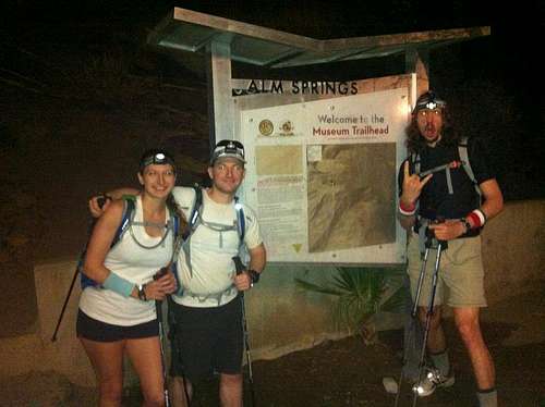
![Unnamed Image]() Museum Trailhead at 4am
Museum Trailhead at 4amThere's a story people tell after they do something like C2C, about how the whole thing started, and almost all of them sound the same. My story is no different. Shortly after summitting San Jacinto for the first time with my boyfriend, Jason, we learned of another trail called the Cactus to Clouds trail. It starts on the valley floor and climbs all the way up to the summit ringing in at a lofty 10,200 feet of elevation gain. It often tops lists boasting 'The Hardest Hikes in America.' And here's the familiar part of the story - as soon as we learned about it, we knew we had to do it!
And thus was our introduction to C2C back in 2004, we never expected nine years would pass before we'd find the right time to attack this beast. Alas, Memorial Day Weekend was shaping up to be the perfect weekend to finally do it. Our friend Chris surprised us by announcing he'd be flying in from Philly to join us, and that's how the three of us found ourselves waking up at 3am, in a crappy hotel room in Palm Springs, on yet another alpine start.
THE HIKE
As we arrived at the Palm Springs Art Museum parking lot we could see clusters of headlamps snaking up the trail high on the mountain - at least two groups had already got an early start. You'd never know it was
3:45am as there were already about six cars in the parking lot and more arriving. As we suited up we chatted with a guy who looked like Rick Steves, and we realized we were neighbors, as he was from Woodland
Hills. He was part of a group of five people, a mix of novices and experienced C2C hikers, and he said they were planning on averaging 1000 feet an hour. Rick was kind enough hobble over to the trailhead with only
one boot on to snap some photos of us at the sign, and at 4am, as planned, we
were off.
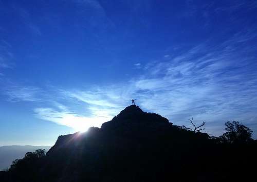
![5:45am sunrise]() 5:45am sunrise
5:45am sunrise
I have read that the C2C is an old Native American trail, started by use and wear and not sanctioned by a state or federal agency, and I believe it - this trail is an absolute maze! We had been forewarned about the confusion at the start so I diligently studied topos, satellite maps, and recorded waypoints in case we got hopelessly turned around. All of my preparations proved futile in the beams of our headlamps. The best we could do was to spot the white blazes someone spray painted along the trail and use them as our guide. The blazes are not well thought out though, placed oddly around switchbacks, and their spacing is sporadic, often leaving us second guessing if we'd missed one. At one point we lost sight of the trail and decided to turn around only to see blazes along the trail in the opposite direction that we were hiking. Absolutely confused, we had to backtrack to get our bearings and eventually discovered the route after wasting some time poking around. After the first mile or two the side trails and shortcuts subsided and we finally got into a good cadence without having to worry about navigation.
The city nightscape below was beautiful - there is something peaceful about seeing a city sleeping. Looking up was a bright full moon kissing the horizon and above on the mountain we could hear one of the groups ahead hooting and hollering. As we gained higher ground the hum of the city started to fade and the twinkling lights gave way to the sun.
Before we knew it we passed the first rescue telephone and realized that we had not seen the infamous sign placed by the Palm Springs Rescue Squad warning hikers not to pass. Perhaps it's just the bratty child
in me, but I was looking forward to snapping a rebellious photo next to the sign. We still aren't sure if we didn't see it, didn't pass it, or if it was removed.
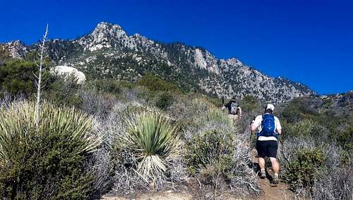
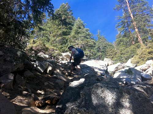
![Unnamed Image]() The steeps loom above
The steeps loom aboveAround 5:30am the sun rose as we gained ground on a second group of brightly clothed hikers. As we neared I was pleasantly surprised to discover and all girl group, each with huge smiles on their faces and exuding positive energy - the girl-power side of me pumped a fist. These five chicks, dubbed the X-girls, had flown down from Washington state and were attempting to do a C2C2C, a 33 mile round trip to the summit and then back to the heat of the desert floor. After chitchatting and taking some group photos we wished them well and told them we'd see them at the top. As we hiked up the trail we continued to hear the girls cheering in the distance and echoed back with some hoots and hollers.
The start of the hike is extremely steep but after the first few miles is mellows out and undulates over rolling terrain. When we started the temperature was a perfect 65°F, now as the sun rose and we slathered on the sunscreen, hiking became slightly uncomfortable as the temperature rose into the high 70s. From here the trail ahead looks very intimidating as the mountain rises up and you know you have one last steep climb before escaping to the flatter, cooler terrain at the tram. We were surprised to pass two more groups of five people, and wondered how many there were on the route that day. We knew it would have been busier due to it being a holiday weekend, but never guessed we would already have met 26 people. The popularity kind of killed the adventure aspect for me.
The steeps loomed large above us and we slowed down our pace just a tad and took guesses on when we would top out at the Desert View trail. We had invited my brother to intercept us at the tram and hike to
the summit with us, but we were ahead of schedule and feared that if he hadn't already left home he would miss us. Jason checked his cell phone and luckily had a signal. He sent my brother a text telling him to
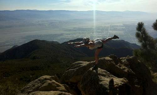
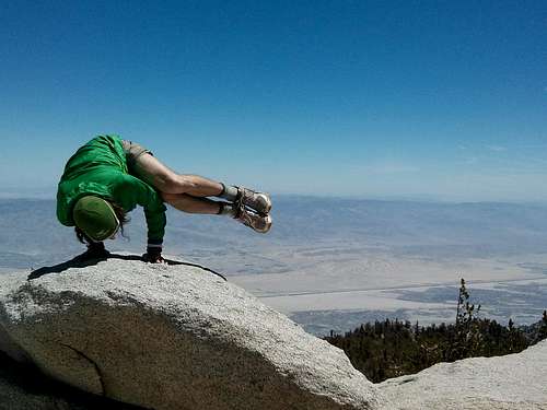
sleep in, to which I'm sure my brother was more than happy to oblige. We were four hours into our hike and everyone was feeling great, so great that we did a little yoga during a water break.
![Unnamed Image]() yoga break
yoga breakThe trail stayed pretty much intact in this section, only once did we get off trail. This was the hottest part of our day, and despite being above seven thousand feet elevation the temperature hit the high seventies. We lingered in the little patches of shade that felt about ten degrees cooler than in the sun. In one of these shady nooks we met two more hikers taking a break from the heat under the weight of some huge backpacks. They had done the trail before and told us we had about a mile left to the tram. The distance and elevation difference is very deceiving on this hike - you can see and hear the tram much of this last portion of trail, and it never looks very far away. I was so unconvinced of how far away the rim was that I thought our GPS had our altitude wrong, and had to bring out a map to double check. I was in fact wrong.
At exactly five hours we crested the rim, way ahead of schedule. In a matter of minutes we were passing the tram, headed to the ranger station to get our permit, and topped off our water. The temperature at the tram dropped to the 60s and felt pleasantly perfect. After a short break we were off toward the summit with the masses of day hikers, families, and about four separate boy scout troops who's troop leaders looked in much better shape than the half dying teenage boys. We kept up a pretty good pace and continued to pass people, we hardly felt like we already had 8K on our legs, although I'm sure we looked like we had. The only person who passed us was an enthusiastic trail runner who politely called trail and gave a chipper good morning as he passed. He looked really fresh and was probably putting in a nice high altitude trail run from the tram to the summit.
Just about a mile or so from the top we came upon a gentleman who stepped aside for us. As we hiked pass he looked at us and asked, "Are you C2C? You must have seen my daughter!" This very animated man
introduced himself as Ranger Dan, as he was a volunteer ranger in Anza Borego State Park, and even sported his uniform. His daughter was one of the X-girls we had met earlier. We chatted for a bit in the middle
of the trail before we left Ranger Dan and said we'd see him on the peak.
The intersection of trails before the push to the summit was a frenzy of activity with people everywhere. I had just eaten caffeinated shot blox and was nearly running the last part of the trail I was so hopped up. The friendly trail runner from earlier was on his return trip and we stepped aside for him and exchanged niceties as he told us we were 'total studs.' Before we knew it we were at the Summit Hut and after the short little scramble over boulders to the summit I looked at Jason and Chris in disbelief - C2C was done and we felt great! Seven hours and thirty four minutes after we started we successfully gained 10,300 feet over 13.7 miles, according to our GPS watch. We got some goofy summit photos and took in the view. Chris challenged me to strike some yoga poses and found the perfect rock to do so. I attempted crow pose for about two nanoseconds before my calves seized and I nearly fell over. All my legs would allow me to do was a tree pose and balancing stick. Chris blew us away, and everyone else on the summit, by somehow having the strength to hold side crow for what felt like minutes, which also makes for dramatic summit photos!
It was like a party when Ranger Dan arrived on the summit as cheers erupted and we all got in a group photo. Any bystander would have thought we were old friends. We talked for a while with Dan while relaxing and taking our time before heading down. We explained to him when we had seen the girls and guessed as to where they might be. Ranger Dan explained that the trail runner said he passed the girls about two thousand feet below the rim. I was confused until he explained that the trail runner who had just passed us was also doing C2C. Absolutely impressive! The whole time I assumed the runner had taken the tram up, not only because he looked so fresh and strong, but because he looked so clean! We discovered that the trail runner started at 6:30am, and we estimated he topped out at 11am, clocking in at an impressive 4.5 hour time! Quite amazing.
All that goes up must come down, and although I was not dreading the hike back to the tram, it certainly felt like an annoyance when all you want is a margarita from the bar. After and hour resting at the top we
headed back down. Not far from the top we exchanged a few words with two other C2C guys we recognized from that morning, congratulating them. With light packs we were able to trail run about two miles
down before we ran into the X-girls! Their stamina proved resilient and they were still smiling and prepared for the hike all the way back down. More well wishes and we left the girls for the second time, complete
with departing hoots and hollers. A short distance later we were giving high fives to the first group of guys we passed early that morning.
And finally, there was the tram station, and its steep zigzagging sidewalk that tortures the hiker who really has to pee. At the bar inside I finally got my margarita and the boys got their beer. We toasted to another adventure completed!
Comments
No comments posted yet.