Pleasant Day on the Gentle Giant
San Jacinto Pk, CA (10804')- Lower 48 prominence rank (6)
Riverside county, CA highpoint
Jean Pk (10670')
Miller Pk (10440')
December 15, 2006
All Pics
~12.4 miles RT, 2900' gain
From Palm Springs Aerial Tramway
A business trip brought me out to the LA area for the 2nd straight year, so I decided to take advantage of the free airfare and climb a couple peaks that are county highpoints and are high on the ultra prominence list in the lower 48. San Jacinto is the Riverside county highpoint and towers over the city of Palm Springs by over 10000'. The vertical relief on this peak ranks it #6 on the lower 48 ultra prominence list, and one can see why when approaching the massive north face. The quickest way to dayhike San Jacinto with the short amount of daylight in Dec was to take the Palm Springs Aerial Tramway, which reduces the hike to around 5.8 miles one way.
I arrived at the tramway visitor center at the bottom just 15 min before the first departure at 10am. The tramway climbs nearly 6000' in about 10 minutes, dropping you off at the Mountain Station terminal at 8516'. The $21 ride was pretty steep for such a short ride, but it was convenient.
![Aerial Tramway]() Halfway up the Palm Springs Aerial Tramway.
Halfway up the Palm Springs Aerial Tramway.
The beginning of the hike starts at the back end of the terminal as you follow a paved walkway down about a 1/4 mile to the ranger station. Here I filled out my day permit and guessed that I would likely be the only one on the trail today. I set out at 10:25am with temps probably in the upper 40's, a perfect day for a hike.
The trail was well packed as this is a popular hike even during the off season, and I was able to get by with trail runners today as the snow left over from earlier in the week was only 2-4" deep and packed down quite well. I made good time to the Round Valley campground and took the left to Wellman Divide. I put on my Yaktrax here as the trail was getting pretty icy in spots.
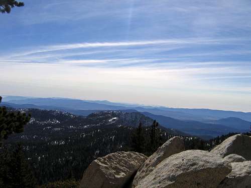
The trail then gently climbs to Wellman Divide at 9700', where I got my first rewarding views of the day toward Marion Pk to the west and the smog bowl of LA.
![Marion Pk from Wellman Divide]() View west to Marion Pk from Wellman Divide.
View west to Marion Pk from Wellman Divide.
From here, there was only a couple set of tracks the rest of the way, but there were still plenty of bare spots on the now south facing slopes. After gaining the ridge at 10560', I followed a set of tracks that pretty much headed straight to the summit boulders, where I topped out at 12:58pm. It was amazing to be this high above the valley floor.
![Mountain Station and Palm Springs]() The start of the hike at Moutain Station and Palm Springs below from summit.
The start of the hike at Moutain Station and Palm Springs below from summit.
The wind turbines below looked like little toothpicks poking out in a giant sandbox. The vertical relief of this peak was impressive as only San Gorgornio stood higher to the north. Temps were probably in the low 40's on the summit and the winds weren't bad. Here is a panorama video of the views from the top. I mistakenly called this the hp of San Bernadino county. This is Riverside's hp.
Summit pano video
After some snacks and a call to my wife, I left around 1:30 and headed over to sister Jean Pk, which is about .6 mile to the south. This peak is unranked, but looked like a fun little side excursion.
![Jean Peak]() Unranked 10er Jean Pk to the south of San Jacinto.
Unranked 10er Jean Pk to the south of San Jacinto.
I quickly made my way down to the saddle, which sits below the point where the trail crests the ridge. From here, it is a short jaunt up a playground of huge, snow covered class 2 boulders to the summit. There was a register and I was the 2nd to sign this month. I arrived at 2:04 and left shortly thereafter, knowing I would be pushing finishing in the dark.
The descent was no problem following my tracks and I made it back to the trail descending to the first switchback at 10400' below the ridge. A named ridge bump on the map named Miller Peak caught my attention and I decided to explore it as it is less only about .1 mile off the trail. This little bump has no more than about 40' of prominence, but offers a nice little class 3 scramble to the summit with a plaque honoring a Boy Scout leader. I was back on the trail at 3pm and heading down for good. I used my Yaktrax as they came in handy on the firm ice all the way down to the ranger station. I encountered a few tourists exploring the rest of the way and made it back at 4:45 just as the sun set to catch the 5pm tram down.
Icy Winds on Baldy
Mt San Antonio ("Baldy"), CA (10064') - Lower 48 prominence rank (21)
Los Angeles county, CA highpoint
December 16, 2006
~7.5 miles RT, 3900' gain
up Ski Hut Trail, down East Ridge to ski lift
Participants: Bruno Lucidarme, Mike Mellin, and Kevin Baker
Baldy is another member of the lower 48 prominence list and is the county highpoint of LA county. From what I have heard, it is probably the most climbed peak in southern CA as it is easily accessible to millions year round. I put out on invite a month or so ago on the CA summitpost forum as I wasn't sure what to expect with conditions. Bruno Lucidarme from Huntington Beach decided to join me and he invited Mike Mellin from Rancho Cucamonga as well.
Bruno met me in the city of Upland so we could carpool in his 4WD from there as the forecast was calling for some snow later in the day and driving down the steep road in a rental was not a good idea. We met Mike at the San Antonio Falls Rd at 6100' and were off at 8:30. The plan was to do a loop hike up the ski hut trail and descend the east ridge to Baldy Notch. We would then ride the ski lift and hopefully beat the storm. Wishful thinking!
The first half mile of the hike follows the San Antonio Falls Rd and hooks up with the trail to the left at 6600'. From here, the gentle hike ends and the grunt begins. The trail initially doesn't have any switchbacks, then somewhat relents about halfway up to the ski hut. Mike set a nice pace up to the ski hut, as we covered 1800' vertical in 1:15.
At this point, the weather was fine but the clouds were enveloping what little views we had. It was warm enough to get by with my Bruins cap and light gloves until we reached the south ridge, where the winds chilled us quick. There were stark clothing contrasts between some of the folks we past and Bruno and myself. One lady had a balaclava on, others were already wearing down coats, and another was wearing plastic boots compared to my trail runners. Bruno was fine without any hat for most of the climb, but our internal furnaces shut down on the descent. When we got out of the trees, I went to the shell hood as I couldn't find my balaclava in my pack, which I later found. Luckily, the wind was behind us.
We topped out at 11:45am with no views beyond a couple hundred feet. Another group arrived shortly after us and got our pic. At the summit I had to resort to my down coat and mittens as the temp was now 20 degrees with high humidity and rime ice beginning to collect on us.
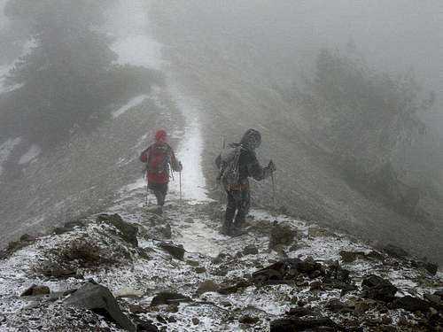
We left at noon and began the descent down the east ridge to the Baldy Notch. The trail would occassionally put us square in the face of the 30-40mph gusts, but not long enough to be too bad. We made it down to the trees below Mt Harwood then did the traverse across the narrow part of the Devil's Backbone. I brought crampons and ice axe for this section, but it wasn't necessary as there were already steps kicked in the snow and the ice was avoidable.
![Devils Backbone]() Iceman traverses the Devil's Backbone. Pic courtesy of Mike Mellin.
Iceman traverses the Devil's Backbone. Pic courtesy of Mike Mellin.
By this time we were all looking like Icemen as the rime ice was caked on us on the windward side.
![Icemen descending]() Rime ice cakes on our clothing on the descent of Devil's Backbone. Pic courtesy of Mike Mellin.
Rime ice cakes on our clothing on the descent of Devil's Backbone. Pic courtesy of Mike Mellin.
We made it down to the fire road and then down to the restaurant at the top of the ski lift and took a break. We walked in and people stared at us like we were aliens or something. One kid said "They must have gone sledding." Mike bought us some sodas and we then bought our $8 tickets for the most miserable ride I have had on a ski lift.
The winds were now sandblasting us in the face with graupel. I left my goggles in the car, so there was no hiding from the fury. The old lift took forever to descend the 1300' or so, but we finally got out of the maelstrom. From the bottom of the lift, it was a short walk down the road to our cars, arriving at 2:45pm to excited city folk sledding down the road.


Comments
Post a Comment