
|
|
Mountain/Rock |
|---|---|
|
|
39.90611°N / 105.94806°W |
|
|
Hiking, Mountaineering, Skiing |
|
|
Summer |
|
|
11773 ft / 3588 m |
|
|
Overview
Ptarmigan Peak is an interesting viewpoint in the Vasquez Mountains. Along with its neighbor Bottle Peak, this small peak is dwarfed by its bigger neighbors to the north, Byers and Bills Peak, but Ptarmigan Peak offers the best viewpoint in which to view those two peaks as well as great views of all the surrounding country from the Flat Tops and Gore Range on the west to the Indian Peaks to the east to Rocky Mountain National Park, the Rabbit Ears Range and the Never Summer Range to the north.This gentle peak offers easy routes, but the peak doesn’t get as much attention as some of the other surrounding peaks.
 This is the summit of Ptarmigan Peak looking south. Byers and Bills Peaks can be seen in the background.
Getting There
East versus West AccessThe two main access routes to Byers Peak are from the Fraser Experimental Forest on the east and the Keyser Creek Drainage on the west. Each access route offers its own advantages and disadvantages.
The East Access is a much shorter drive for those living in the Fraser River Valley or the Front Range. The access road is also better.
The West Access definitely offers the more scenic routes for climbing the peak. The trails are also more pleasant and less well used. The disadvantage is that the access road is rougher and it is a longer drive if you are coming from the east (as do most people living in Colorado).
Fraser Experimental Forest Trailhead (East Access)
There are a few routes to get to the trailhead, but this one may be best. From Highway 40 at the shopping center near the canter of Fraser, turn south on County Road 72 for 0.2 miles. Turn right on Fraser Parkway for 0.8 miles. Turn left on County Road 73 and follow it for 7.0 miles. There are a few side tracks, but stay on the main road. Make a right and follow the road 3.0 miles to the gate and trailhead. The road has a few potholes, but is suitable for two-wheel-drive vehicles.
Keyser Creek Trailhead (West Access)
East of Parshall (not far east of Kremmling) and on Highway 40 between mile post 197 and 198, turn south onto Country Road 3. Follow County Road 3 until you reach County Road 32 (FR-139), mile 12 (formerly between mile markers 15 and 16?) on County Road 3. Follow County Road 32 for 4.7 miles and turn right on FR-136 on the road marked for Lake Evelyn and Bottle Pass Trail. The small parking area at the trailhead is reached after another 3.9 miles. The last road is sometimes rather rough in places, but if you drive slowly, most vehicles can make it.
 This is Ptarmigan Peak as viewed from Bottle Pass.
Routes Overview
Fraser Experimental Forest RouteFor people living in the Fraser River Valley or along the Front Range, this route offers the shortest drive. It’s a pretty route, but not quite as scenic as the Keyser Creek route. Most of the trail is good, but fades away near Bottle Peak (which is climbed over along the route). From the Bottle Peak area to the summit, the trail is faded or non-existent, but you can see your objective in front of you and cross country travel is easy.
The round trip distance to climb Ptarmigan Peak from the Fraser Experimental Forest Route is 6.0 miles round trip with 2300 feet total elevation gain.
Keyser Creek Route
This is the most scenic route up Ptarmigan Peak. The first half of the trail is good, but then is more faded as you approach Bottle Pass. After Bottle Pass, there is no trail, but cross country travel is easy.
The round trip distance to climb Ptarmigan Peak from Keyser Creek is 5.4 miles round trip with 1800 feet elevation gain. If you climb Bottle and Ptarmigan Peaks in the same trip, the round trip distance is 6.2 miles round trip.
See the route pages for more details on either route.
 This photo was taken on the slopes above Bottle Pass and on Ptarmigan Peak. Byers and Bills Peaks are in the background.
Red Tape
No permits are required, but normal designated Wilderness Area rules apply.Camping
Camping is available below the Fraser Experimental Forest trailhead at the Byers Creek Campground. Check with the Forest Service (970-498-2770) for the current fees. Because the Eastern Trailhead lies within the Fraser Experimental Forest, overnight camping is not allowed except at designated camping areas. For information on current camping restrictions and other camping areas in the vicinity, contact the Sulphur Ranger District.Keyser Creek Drainage (West Access) offers several undeveloped campsites.
When to Climb
Late June through sometime in October would be considered the normal season to climb the peak. Expect to walk through quite a bit of snow before mid-June.The peak would make a safe winter ascent in most conditions, but the peak would require a long walk in that season.
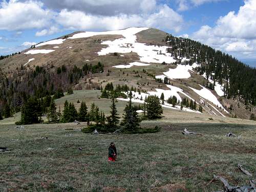
 Expect some big snow drift on Ptarmigan Peak in early summer. This is June 27 2009.
Mountain Conditions
For current road and trail conditions, contact:Sulphur Ranger District
9 Ten Mile Drive
Granby, CO 80446
970-887-4100
WEATHER FORECAST
Below is the climate summary for nearby Berthoud Pass at 11,315 feet elevation. These are all averages, so expect more variation, but this will give you a good idea about the climate at higher elevations around Ptarmigan Peak. *National Weather Service Data 1950-1985.
| MONTH | HIGH | LOW | SNOW DEPTH | DAYS W/PRECIP |
| JAN | 21 | 1 | 42" | 19 |
| FEB | 24 | 2 | 52" | 16 |
| MAR | 29 | 6 | 63" | 20 |
| APR | 36 | 14 | 67" | 17 |
| MAY | 45 | 23 | 53" | 16 |
| JUN | 54 | 32 | 17" | 11 |
| JUL | 62 | 39 | 0 | 14 |
| AUG | 60 | 38 | 0 | 14 |
| SEP | 53 | 31 | 0 | 11 |
| OCT | 42 | 21 | 3" | 10 |
| NOV | 30 | 10 | 14" | 15 |
| DEC | 23 | 3 | 29" | 18 |