
|
|
Mountain/Rock |
|---|---|
|
|
39.78600°N / 105.822°W |
|
|
12521 ft / 3816 m |
|
|
Overview
This peak is to the west of Berthoud Pass. Since this mountain is fairly easy to climb, it is ideal for beginners, families, or just anyone who has little time on their hands and wants to climb an alpine peak. Even though the hike is easy, the views are spectacular, and the peaks rise well above the timberline. The easy nature of the peak also belies their danger as severe thunderstorms and lightning strikes are prevalent throughout the summer months.The peak is great for winter climbs as well since the trailhead at Berthoud Pass is open year round. With easy access and a high elevation trailhead, this is a good peak to climb in winter.
 Looking back towards Stanley from the slopes of Colorado Mines Peak.
Getting There
The trailhead is at Berthoud Pass, which is on mile marker 243 on Highway 40. Berthoud Pass can be reached from the north and Fraser and Winter Park or from the south and Empire. The Empire exit off I-70 is exit 233 for those driving from the south. Park at the now closed Berthoud Pass Ski Resort parking lot. The trailhead is across the highway. Highway 40 is open and plowed year round allowing easy year-round access to the trailhead.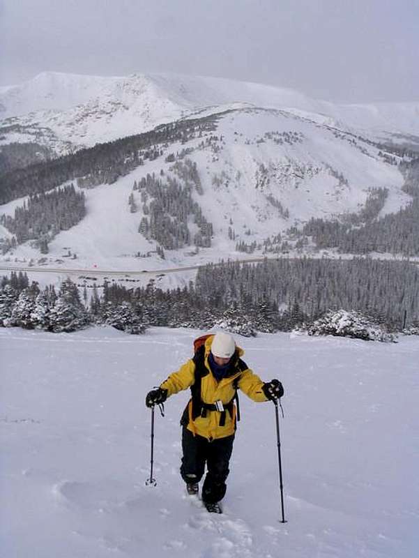 The summits behind are unranked summits leading to the lower slopes of Stanley and HWY 40 can be seen below.
Routes Overview
The route I took was the Berthoud Pass Route. Breifly put, this route climbs west from Berthoud Pass to peak 12,391. From there, the route follows the up-and-down ridgeline over two peaks before reaching Mount Stanley. See the route page for details.From the summit of Stanley Mountain, it is possible and highly recommended that you continue west to Vasquez Peak, assuming you have the time and energy. Click here for information on the continuation of the route to Vasquez Peak and here for the page on Vasquez Peak.
The new Trails Illustated Map; Winter Pass, Central City, Rollins Pass shows a new trail from the West Fork Clear Creek up to the Continental Divide Trail. This could then be followed east to Mount Stanley. I am not familiar with the route, but it is likely to have similar difficulty than the route from Berthoud Pass.
 Along the ridge to Stanley Mountain.
Red Tape
No permits are required.When To Climb
This a great little peak year round. The snow free season is late June through early October. Since the route follows the ridge-tops, avalanche danger is usually fairly low as long as you don't stray from the ridge. Highway 40 is plowed in winter allowing for quick and easy access year round.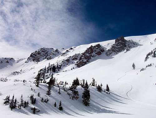 This spectacular bowl is located just north of Mt. Stanley and offers spectacular ski descents when avalanche conditions are prime.
Camping
This peak is mostly a day climb only, but there are campgrounds along Highway 40 in the Fraser Valley, and one just south of Berthoud Pass.There are five campgrounds between Berthoud Pass and Winter Park. These are the campgrounds in order from Berthoud Pass north to Winter Park:
Second Creek Campground
DAR Campground
Spruce Lodge Campground
Midland Campground
Idlewild Campground
For info on these campgrounds listed above, call the ranger station in Granby at 970-887-4100.
There is one campground along Highway 40 just south of Berthoud Pass:
Floral Park Campground
For information on this campground, call the ranger station in Idaho Springs at 303-567-2901.
Mountain Conditions
For current trail and snow conditions, more information, and access issues contact:Sulphur Ranger District
9 Ten Mile Drive
Granby, CO 80446
970-887-4100
BERTHOUD PASS AREA MOUNTAIN WEATHER FORECAST
Below is the climate summary for nearby Berthoud Pass at 11,315 feet elevation, and at the trailhead. These are all averages, so expect more variation, but this will give you a good idea about the climate at higher elevations in the area. *National Weather Service Data 1950-1985.
| MONTH | HIGH | LOW | SNOW DEPTH | DAYS W/PRECIP |
| JAN | 21 | 1 | 42" | 19 |
| FEB | 24 | 2 | 52" | 16 |
| MAR | 29 | 6 | 63" | 20 |
| APR | 36 | 14 | 67" | 17 |
| MAY | 45 | 23 | 53" | 16 |
| JUN | 54 | 32 | 17" | 11 |
| JUL | 62 | 39 | 0 | 14 |
| AUG | 60 | 38 | 0 | 14 |
| SEP | 53 | 31 | 0 | 11 |
| OCT | 42 | 21 | 3" | 10 |
| NOV | 30 | 10 | 14" | 15 |
| DEC | 23 | 3 | 29" | 18 |