
|
|
Mountain/Rock |
|---|---|
|
|
45.10988°N / 2.71088°E |
|
|
Hiking, Mountaineering, Mixed, Skiing |
|
|
Spring, Summer, Fall, Winter |
|
|
5558 ft / 1694 m |
|
|
Overview
 From North
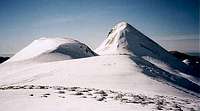 Snowy
SnowyPuy Griou is the sharpest mountain of the Cantal. Surprisingly rocky and steep, this pile of basaltic screes is in fact the remain of the volcanic chimney that formed the huge former volcano of the Cantal; thus despite it lies a bit apart from the main ridge which runs from the Bec de l'Aigle to the Puy de la Tourte.
It makes a fine goal for a day walk from the bottom of the neighbouring valleys (Vallée du Lioran and Vallée de la Jordane). The panorama to the rest of the main mountains of the Cantal is breathtaking.
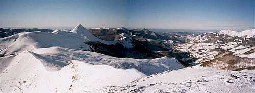 January panorama; Griou is left
Getting There
 Sunrise
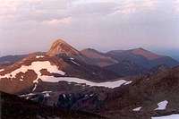 Sunrise
 From Lioran
 From Lioran
 From Lioran
 From West
The Puy Griou is accessible from the 2 valleys mentionned above: Vallée du Lioran and Vallée de la Jordane.
The trailhead in the Jordane (one of the most picturesque valleys of the Cantal) is located after the village of Rudez, where the road makes the first sharp turn to a lace. One can also start in Liadouze a bit before.
In the Lioran valley, many possible trailheads such as St Jacques des Blats, Les Boissines, Les Chazes or the Alagnon valley at the Lioran pass.
The Pertus pass has a road that links the 2 valleys and is also a trailhead.
Let's underline the Lioran pass has a train station, which is very practical to hike in the Cantal arriving by the public transports.
View Larger Map
 January panorama; Griou is left
Routes
 From Puy Mary
 From Peyre Arse
 N route
 S route
There are many marked trails around the Puy Griou, including the compostelle way GR400, going just Est below the top from N to S (from Col de Rombière to Col du Pertus).
No marked trail lead to the top, however two obvious routes reach it from each side of the ridge, north and south.
The most direct and easiest is from the north, coming from Col de Rombière, as we reach first a flat plateau marked on the IGN map 1617m high. This option also allows combining its visit to other surrounding tops.
From the South, the slope is much longer and steep, and give a much bigger feeling of climbing a real mountain. Before reaching the foot of the mountain, we cross beautiful mountain forests as we are just below the tree line. In winter this route may require crampons when snowy.
Of course the most interesting is to make the whole traverse of the mountain.
The highest trailheads like Rudez and the Lioran are best to reach Col de Rombière, while those lower in both valleys are best to reach the south side.
Map : 2435OT
 Summit panorama
Red Tape
 Summit
 Hiking up
The Cantal is a natural park, but with no strict regulations, except the most obvious (no garbage, no fire, etc). Leaving the trails and wildcamping over the treeline will not cause any problem.
Just one point: with dense cattle-breeding, mind to close back the gates behind you when you happen to cross one.
Accomodation
Unfortunately, there is no mountain hut in the whole range of the Cantal, and the basic hikers accomodations are not very common, since this region is rather famous for gastronomy tourism, traditions, etc, rather with B&B of a certain standard.One will find many accomodations on this page.
There is also no official campsite...
Since the bivouacquing rules are not very strict in the region (let's say bivouacquing is not common at all here...) one will easily set a tent over the tree line in the evening without any trouble.
There are also some basic unguarded sherperd huts open to hikers, called "burons", in various state, and whose list is here:
http://www.cantalpassion.com/burons_association_sauvegarde.htm