
|
|
Canyon |
|---|---|
|
|
39.46429°N / 110.23802°W |
|
|
Hiking, Canyoneering |
|
|
Spring, Summer, Fall |
|
|
History

Range Creek Canyon came to the attention of the world several years ago as a place where the remnants of the ancient Fremont civilization had been remarkably well preserved. The property on which the canyon is located was owned by a rancher named Waldo Wilcox and had been in the Wilcox family since 1951. He had kept the historical treasures on his property a secret in the hopes of protecting them from damage and looting and was quite successful in this endeavor. In 2001, however, he decided that it was time to sell his beautiful and secluded ranch. The sale was made to the non-profit Trust for Public Land, who in turn transferred the land to the State of Utah. The State placed control of the site under the Division of Wildlife Resources (DWR) and quietly began archeological research on the site. Since then DWR has been tightly controlling access to the canyon to preserve the integrity of the archeological sites. Today, the stewardship of this fantastic site is being transferred again, this time to the University of Utah. Many people are now patiently waiting to find out what this new change means.
Overview
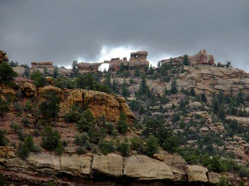
Range Creek Canyon is not a slot canyon nor is it technical in any way. There is an old dirt road that runs the full length of it that served as access when the canyon was a working ranch. It’s used today by scientists and management officials to facilitate their work and by hikers as the primary trail through the area. The canyon is beautiful and very much a worthwhile hike even without the archeological component. The ancient artifacts in the area are not dramatic or highly visible like what you would see in Mesa Verde N.P. or Chaco N.H.P. They consist of pictographs and petroglyphs, remnants of pithouses, granaries high on the cliff walls, pottery shards and other implements. Looking for these different things feels somewhat like a treasure hunt. There are no interpretive signs or markers so you have to be a bit of an archeologist yourself. It should go without saying, but when you come across artifacts, don't disturb them. Take only photos with you when you leave. Native American artifacts aren’t the only things you will find in the canyon. The area is rich in wildlife and you may come across anything from bighorn sheep to foxes. This is bear country, so when you’re there take the normal precautions you would anywhere there are black bears present. There’s a small herd of wild bison in the bookcliff region that encompasses Range Creek. The bison aren’t in the canyon today, but who knows; sometime in the future they may also be part of the experience. There are also mountain lions in the area. In fact, Waldo Wilcox, the former owner of Range Creek Canyon, used to trap them and sell them to zoos many years ago to supplement his income. The hike through the area is a little over 14 miles, one direction. The only water in the area comes from Range Creek. It’s a cool, clear stream but needs to be filtered or treated before you drink it. Even though this is a desert environment, the north end of the canyon is wooded and the transition in vegetation as you hike through is very pleasant and interesting.
Getting There

Heading north on Route 6 (coming from Interstate 70): Watch for the intersection with Highway 124 approximately 33 miles past the intersection of Route 6 and Interstate 70. A sign here should indicate that this road leads to Horse Canyon. Turn right here and head east for about 4 1/2 miles until you reach a "T" intersection. Take the turn to the right. The road will quickly turn to dirt, pass over a one lane bridge and then through the site of the Horse Canyon Mine. About 3/4 mile past the old, abandoned mine buildings you will reach another intersection. Turn left here and continue on about another 8 miles until you reach the locked gates at the head of the canyon. WARNING: The dirt portion of this road is very steep in places and may become impassable in wet weather, even for a 4 wheel drive vehicle with good tires.
Heading south on Route 6 (coming from Interstate 15): After passing through Price and then Wellington, begin watching for Highway 123 to East Carbon/Sunnyside, leaving Route 6 and heading east. The intersection is about 9 miles past Wellington. Turn left here and continue approximately another 9 miles until you reach the intersection with Highway 124. Turn right here and continue on, following the signs to Horse Canyon. The road will eventually turn to dirt, pass over a one lane bridge and then through the site of the Horse Canyon Mine. About 3/4 mile past the old, abandoned mine buildings you will reach another intersection. Turn left here and continue on about another 8 miles until you reach the locked gates at the head of the canyon. WARNING: The dirt portion of this road is very steep in places and may become impassable in wet weather, even for a 4 wheel drive vehicle with good tires.
Official maps and directions may be found here.
Red Tape
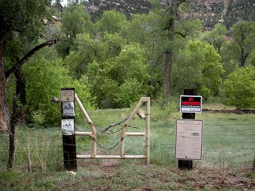
As of May 2020, only 28 members of the public are allowed to enter the canyon per day. Travel is restricted to foot and horseback, though several specific groups and agencies have the authority to operate vehicles in the canyon and you may encounter them in there. In order to gain access, you have to first buy a permit. They only cost $1 and are valid for the entire season that the canyon is open to the public. After you purchase the permit, you must register for the days your wish to enter the canyon and may make reservations for up to five consecutive days. This is done over the internet at this website. After you reserve the days that you want, don't forget to print a copy of these day permits: you're required to carry them with you while you're in the canyon. These rules were developed by the Utah Division of Wildlife Resources, who has operational control of the canyon. However, this control is in the process of being transferred to the University of Utah and no one is really sure how the rules are going to change. The University has indicated that it will continue to allow limited public access.
Camping
Overnight camping is not allowed in the canyon, however there is a fire ring and a campsite just outside the north gate.
External Links
Utah Museum of Natural History
Local Weather