|
|
Route |
|---|---|
|
|
47.09809°N / 11.07160°E |
|
|
Mountaineering |
|
|
Summer |
|
|
Most of a day |
|
|
5.4 (YDS) |
|
|
AD |
|
|
IV |
|
|
Overview
The ridge traverse from Westlicher to Hoher Seeblaskogel is a somewhat extraordinary, long and strenuous yet rewarding undertaking. The ridge stretches over almost 1.3 km and - as common in Stubai - has not always the best rock quality. However, delicious climbing passages in solid rock are also present.Difficulty varies from UIAA I+ to IV-, but is mostly around II (PD). Views near and far are superb.
Note: the access to the ridge makes use of the still existing small Winnebach glacier. This access may become much more difficult and turn nasty once this glacier has gone ...
Thanks to Niels Hemmann, Jena, who soloed this ridge in July 2008, for sharing this info. The photos shown here are his.
Getting There
Best starting point is Winnebachseehütte, 2380m. You reach this hut from Längenfeld/Ötztal via the hamlet of Gries (where the car road ends).Route Description
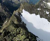
 Looking back from P. 3122m to Westlicher Seeblaskogel. The upper part of the access glacier is also seen.
From Winnebachsee hut follow the marked path to Winnebachjoch until you pass at about 2700m the rest of the Winnebachferner to your right. Climb the glacier straight to the saddle, where it ends somewhat beneath Westlicher Seeblaskogel, which is to the right of this saddle (beware of going astray by turning right to early).
In the saddle turn left (northeast) and follow the ridge to a peak which could legitimately be called Mittlerer Seeblaskogel (Central Seeblaskogel) but has only the designation P. (point) 3122 on the (btw recommendable) 1:25000-Alpenverein-map. Mostly you can keep directly on the ridge, but e.g. P. 3122 is circumvented in the south flank. In this 1st part of the route the main difficulties occur.
After P. 3122 you descend to another saddle (the deep one well visible in the primary image). From here the rest of the ridge to the top of Hoher Seeblaskogel runs out straightforwardly in continued grade II, sometimes III, in better rock.
Essential Gear
A big bottle of water and some trail mix.A rope, some slings or nuts may come in handy at some passages.
The same applies to crampons and pick for the glacier access to the ridge.


