Foreword
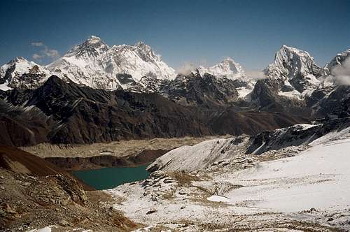
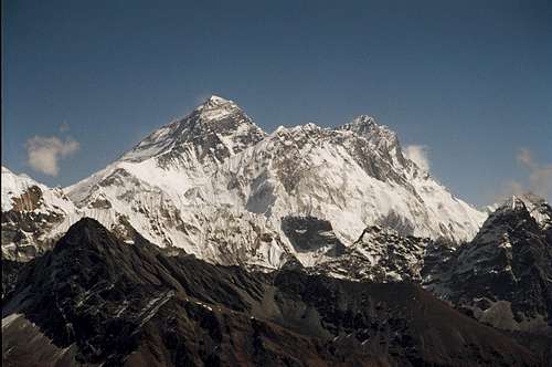
![The Everest group]() The view east from the Renjo La. Pumo Ri, Everest, Nuptse, Lhotse, Makalu, Cholatse
The view east from the Renjo La. Pumo Ri, Everest, Nuptse, Lhotse, Makalu, Cholatse |
Dare I say this? On balance I was quite disappointed by my first trip to Nepal.
Over the years I’ve devoured all the accepted classic accounts of travel and climbing in the Himalaya. Hunt, Hillary, Terray, Bonnington, Messner and many others have described a land of unspoiled, pristine beauty. All have waxed lyrical on idyllic approach marches, friendly locals, charmingly eccentric customs, deeply felt spirituality and more. Who wouldn’t want to experience all this? It was certainly high on my post-retirement trip list and when an invitation to join a well-experienced group arrived shortly after kissing goodbye to work for good, I was in like the proverbial Flint.
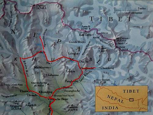
The aim of the expedition was not only to climb Lobuche East Peak in Solu Khumbu but to do so by a long, seldom traveled and circuitous approach. Of the many trekking groups that visit Solu Khumbu, 90% travel the well-worn path from Jiri or Lukla to Namche Bazaar and then make their way up the valley of the Imja Khola to Gorek Shep and Everest Base Camp. Everest is shielded from view for most of the way and, therefore, everyone goes up Kalar Patar for the obligatory view of the SW Face and the Icefall. To get more expansive views over the whole area one needs to be much further west in order to stand back, as it were, and see everything. This is possible by ascending the valley of the Dudh Kosi from Namche as far as Gokyo and then either climbing Gokyo Ri or ascending to the fifth Gokyo Lake closest to Cho Oyu. Most of the 10% who don’t go directly to Gorek Shep take this route. There is, however, a third and infrequently traveled possibility further to the west. The valley of the Bhote Kosi leads to the Nangpa La pass and provides an important access route for Tibetan traders coming down to Namche, their yaks piled high with all those Chinese knock-off Nikes, Adidas, etc for sale in the market there. The plan was to approach via this valley, cross the Renjo La pass (5,425m) to the valley of the Dudh Kosi and then proceed from Gokyo over the Cho La (5,419m) and on down the Chola valley to Lobuche.
Dhasain in Cheterali
![Dhasain Sacrifice in Cheterali]() Dhasain sacrifice in Cheterali
Dhasain sacrifice in Cheterali![Cheterali]() Morning mist over the Darde Khola
Morning mist over the Darde KholaMy wife Gwen and I left Victoria, BC on October 15th with one bag of gear and 3 bags of stuff to give away. We’ve been on so many trips in the past when we have met many people in need, have had nothing with us to give away and had to take addresses to send things later. Unfortunately, the 3rd world being what it is, these gifts never make it to their intended recipients. We’ve even had an instance of empty wrapping paper being delivered to the addressee. How cynical is that? This time we were determined to make sure everything was delivered where it was most needed.
After the obligatory overnight in Bangkok, we arrived in Kathmandu on the 18th to find the festival of Dhasain in full swing. The next few days were a whirlwind of visits with new Nepali friends. The contents of the 3 bags had no shortage of takers. By our standards, even middle class Nepalis from Kathmandu are very poor, so people were grateful for all that we brought. Reciprocation is paramount in the east of course and this meant that we were privileged to be invited to Dhasain celebrations in private homes on several occasions. Without a doubt, the best of these visits was to the village of Cheterali on the banks of the Darde Kola about 30 km west and 1000m below Kathmandu. We took a taxi to the small town of Rangepur and then walked for 2 or 3 hours down the “mini truck” road and into the sub tropics. What a breathtakingly beautiful place! What a wonderful welcome from the villagers. We spent the day there feeling humbled; watching and being watched by lives so different from our own. Since our hosts were Brahmin and we quite obviously weren’t, our bed was on the house balcony above the cattle byre. If you needed to visit the bathroom in the night you had to run the gauntlet of the rather aggressive family water buffalo stationed outside. Coming out was OK, you could bonk her on the nose with the empty sluice bucket. Going in was epic; trying not to get bitten or butted while juggling with a full bucket of water!
The following day was the part of Dhasain set aside for sacrificing animals – or “cutting” as Nepalis call it. This was going on throughout the valley and scenes rather difficult for my faint western stomach punctuated our walk back up to Rangepur. I can say with conviction, however, that not a shred (no pun intended) of the sacrificed animals goes to waste.
Into the Mountains
The rest of the group arrived from London on October 23rd and on the 25th we took the early morning flight to Lukla. The group consisted of 14 clients, mostly Brits plus 2 Aussies, a Kiwi, an American and we two Canadians. With us we had 3 climbing and 2 trekking sherpas and a kitchen staff of 5. We started out with 30 or so porters but lost some to illness (and raksi) as the expedition progressed.
![Afternoon cloud]() Afternoon cloud
Afternoon cloud
It didn’t take long after landing in Lukla for the first signs of disappointment to creep in. Visions of pristine and idyllic soon gave way to the realities of squalor and crowds. My goodness, the crowds! I’m not so naive as to have
really expected some kind of modern day Shangri La in Nepal but I was completely taken aback by the hordes of people who make this trek. All the way up to Namche and beyond there are literally hundreds of people and animals constantly in view. It’s not only that there are so many western visitors but that they’ve got to have their beer, bottled water, chips etc. This and the fact that everything has to be carried in is what causes such congestion.
Trekking days in the Himalaya have been well described many times in SP and elsewhere, so I won’t belabour the reader with too many details. Suffice to say that ours were no different. Awakened early to “bed tea”, pack up by 6.30 (trying not to get drenched in a frost shower from the roof of the tent) and then a leisurely breakfast in the mess tent while the porters got a start on their carry for the day. Mid morning stop for tea, lunch prepared by the kitchen staff and a halt about 3pm all made for mellow days, at least at lower altitude. We camped most of the time with two nights in a lodge in Namche as part of the acclimatisation process. Here again the idyll suffered. Camping was almost always outside lodges on yak dung covered “pastures”. No lying back on scented turf gazing up at the crystal heights as I had optimistically imagined and as many of the eminent authors above had led me expect. In fact, every afternoon without fail, the clouds would roll in and it would get really cold, really quickly and I would often be forced into my sleeping bag before 4pm.
Namche to Relamo Tsho
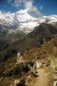
From Namche we headed initially west and then north from Thamo village to the wonderfully named Thame Og with it’s monastery at over 4000m. Perched in a breathtaking location and a particularly fine example of that unique combination of tranquility and squalor that these establishments exhibit.
Thame sits at the junction of the Bhote Kosi and Tengpo valleys, the latter providing access to the Taschi Lapcha pass into the Rowaling Himal. Unfortunately, the habitual afternoon cloud obscured the view up the Tengpo which was a pity because a traverse of the Rowaling over the Taschi Lapcha and into Solu Khumbu is a route I'd like to do and I'd like to have seen what I might be in for.
![West from Namche]() Teng Kangboche
Teng Kangboche | ![Group above Lungden]() Group above Lungden
Group above Lungden | ![Climbing Sherpas]() Climbing sherpas
Climbing sherpas | ![Renjo La base camp]() Camp below Renjo La
Camp below Renjo La |
We then gradually gained altitude over two days before leaving the route to the Nangpa La at Lungden, heading east and setting up camp at Relama Tsho below the major pass, the Renjo La, at 4,850m. Gwen, who had originally only planned to come as far as Namche, left us a half days march north of Thame, having reached 4000m and returned with a porter to Thamo. Her intention was to offer her services at the school there. More on this later.
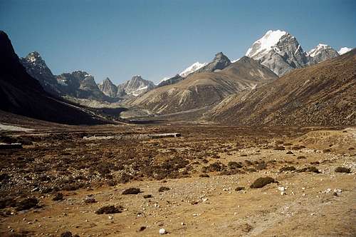
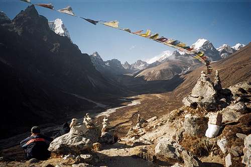
The preceding three days had done a lot to restore my opinion of the area. We had left the crowds behind at Thame and the valley of the Bhote Kosi, if not exactly wilderness, had certainly proved to be a lot wilder than the ground covered hitherto. Once the crowds had disappeared it was easy to focus on the stunning peaks all around and simply ignore what I didn’t like. The camp at Relamo Tsho at over 4,800m was frigid but it’s location right under the big pass more than made up for that. This is more like it I thought.
Crossing the Renjo La
![Climbing the Renjo]() Climbing the Renjo La I
Climbing the Renjo La I | ![Almost at the pass]() Climbing the Renjo La II
Climbing the Renjo La II |
To this point I had been moving surprisingly well never having climbed higher than 3400m before. I had been told that the secret to successful acclimatisation was to drink 6-8 litres of fluid per day and, aside from having to pee constantly, it seemed to be working fine. I had a cold but so did everyone else. The night below the Renjo was my first experience of Cheyne Stokes breathing. I can’t say I enjoyed it but since I felt fine in the morning, didn’t think too much about it. I also had some facial edema according to others. Whatever – I still felt fine.
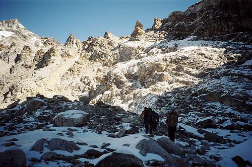
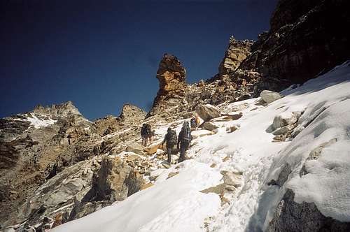
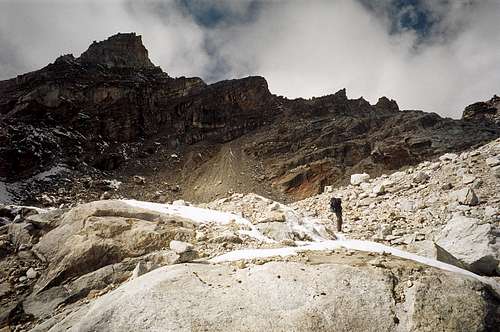
We left camp about 9am having waited for the sun to reach at least part of the route and topped out on the gunsight pass at 5,425m right on the stroke of 11. This is one that even Sherpa porters probably can’t get over in flip-flops. Quite steep and icy with a little Class 2 here and there. It made for an enjoyable challenge when combined with the altitude.
What a view!! The Gokyo Lakes 1000m below and the whole eastern horizon filled with the names of legend. Pumo Ri, the Everest group, Makalu, Ama Dablam, almost unrecognisable from this western aspect and Taweche. The biggest thrill of all was being able to see so much of the north face of Everest from this point. I hadn’t expected it. The steps on the north ridge were clearly visible as was the south summit above the southwest face. No plume that day but you can’t have everything. I was completely bowled over. The Renjo La is absolutely the best place from which to see the whole Everest massif and, at least to this point, almost no one goes this way. Now I really began to see what all the fuss was about. Summiting the pass also apparently earned me the loss of my Himalayan virginity.
There’s no room for complacency at altitude and if I had been taking it in my stride to this point I was soon to receive my come-uppance. Thirty minutes, a couple of hundred metres below the summit of the Renjo and completely out of the blue I was overtaken by the mother of all headaches as well as overwhelming dizziness. One moment I was bowling along happily and the next I was on my ass and feeling like death warmed over! It was that sudden. I made it down to Gokyo eventually and felt better at lower altitude but what a shock. And whilst descending too. I hoped it was nothing more than low blood sugar since I’d eaten nothing for lunch, not fancying too much the paraffin flavoured puri on offer.
![Telephoto of Everest, Nuptse and Lhotse from the Renjo La]() The Everest group from the Renjo La
The Everest group from the Renjo La | ![The Renjo La from the east]() Descending the Renjo
Descending the Renjo |
Gokyo to the Cho La to Pheriche
![Gokyo 4th Lake]() 4th Gokyo Lake
4th Gokyo Lake![Everest N and SW faces]() Everest N and SW Faces
Everest N and SW Faces![Cho Oyu]() Cho Oyu
Cho Oyu![The Renjo La reflected in Gokyo Lake]() The Renjo La from Gokyo
The Renjo La from Gokyo![The Ngozumpa Glacier]() The Ngozumpa glacier
The Ngozumpa glacier![Ama Dablam on the descent from the Cho La]() Ama Dablam
Ama Dablam
The next day should have been a rest day but, instead, I went back over 5000m to the 5th Gokyo Lake for another view of the north face of Everest as well as a closer view of Cho Oyu. This was a wonderful walk but much further than I anticipated and I experienced the same symptoms as on the previous day coupled this time with poor performance going uphill. There could be no denying that I was suffering from AMS. I began to be discouraged. My mood was also not improved by the reappearance of the crowds at Gokyo.
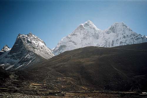
After Gokyo our route took us a little south and then due east over the Ngozumpa glacier to Thangnak and up to the foot of the Cho La pass (5,420m). Our camp below the Cho La at over 5000m was memorable on two counts; for being the coldest in my experience and for providing the best nights sleep I got over the whole trip. The ascent of the Cho La was to be my last significant climb of the trip. It was a much easier climb than the Renjo but AMS symptoms returned again and I finally had to admit to myself that I would be a liability on a rope with others. I decided, therefore, to descend to the village of Pheriche at 4250m and see if I couldn’t shake the effects of altitude there. The clinic at Pheriche has a display outside listing the various symptoms of AMS. Oddly enough, just about the only one I could swear I
didn’t have was loss of appetite.
After a couple of days rest at Pheriche I went slowly back up to ~4600m on the route to Chukung. This gave wonderful views of the whole Nuptse ridge as well as the very different north aspect of Ama Dablam but I felt dreadful throughout this short excursion and next day was forced to descend once again to Deboche at 3800m. This was where I was finally able to shake the symptoms and after over a week of suffering feel more normal again. With hindsight, when unable to shake the symptoms of AMS at Pheriche, I should have descended sooner than I did to Deboche. Even that became academic, however, when I almost immediately succumbed to a really bad chest infection. I was to enjoy the effects and after-effects of this for the next 3 or 4 months!
![Ama Dablam N Aspect]() Ama Dablam from Chukung
Ama Dablam from ChukungSuccess on Lobuche for 6
![Lobuche E from Pheriche]() Lobuche East
Lobuche East
In any event six of our group summitted Lobuche East on November 5th in perfect weather and in the course of a 13 hour day. The only day in almost 3 weeks, in fact, when afternoon cloud didn’t come in. Someone had been saying their prayers. I also thought it more than significant that all the summiters had had previous Himalayan experience.
Everyone got together a few days later at Deboche and we walked back to Namche the next day.
The School at Thamo
![The School at Thamo]()
![The School at Thamo]()
An hour’s walk north of Namche and there was Gwen waiting for us by the path. Did she have her own tale to tell! Not only had she helped the school at Thamo by teaching English, she had also become self-appointed school fundraiser. The children are so poorly dressed that it makes your heart ache just to look at them. So Gwen set about any passing trekkers and succeeded in raising 20,000 rupees (about C$400) from many generous souls anxious to contribute to such a deserving cause. She then took it and her porter back down to Namche and negotiated with the Tibetans in the market there for 45 pairs of shoes and socks, 45 sets of toothpaste and brushes and 3 full uniforms for the worst dressed of the kids. She literally shod the whole school. By the time we got there she was already a legend in the area. The whole village of Thamo turned out to give her a tea ceremony at which she was buried in prayer shawls. The main thing everyone wanted to know was when “Gwen didi” was coming back. In fact she went back this year (2006) this time with our daughter and carrying dictionaries and fleeces for the whole school. We’ve taken to calling her “Mother Gweresa”.
Postscript
A couple of days later we were back in the polluted hustle and bustle of Kathmandu, it was festival time again (Dipwhali this time) and the mountains felt like a dream.
Would I go back? A few months of routine later and I became more inclined to remember all the wonderful bits and to forget the attendant pain and sickness. There were so many truly magic moments. Cheterali, the Dhasain parties, Sherpas singing around their fires in the campsites, the company of a great bunch of folks and, best of all, the view from the Renjo. Sensory overload all of it. I think it’s also important to prepare for the overall experience, not just the mountains, hugely impressive as they are. Let your gaze wander down from the peaks and there are signs of man everywhere in abundance. But that’s how it is, at least in this part of Nepal and these signs and the people that make them belong there and are part of what you go to experience. Accept this and maybe it ain’t so bad after all.
Page Visitor Statistics












Comments
Post a Comment