
|
|
Route |
|---|---|
|
|
34.28890°N / 117.6458°W |
|
|
Hiking, Mountaineering |
|
|
Spring, Summer, Fall, Winter |
|
|
Half a day |
|
|
Overview
The San Antonio Ski Hut/Baldy Bowl Trail is considered the most direct route to the summit of Mount Baldy (10,064'). The distance estimates range from 8.5 to 9 miles round trip with approximately 3900 feet of elevation gain. This climb is considered very strenuous.
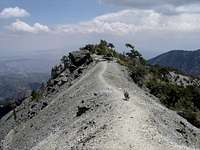
As you start up the fire road you will soon enjoy views of the San Antonio Falls. Continuing on you will pick-up a use trail that climbs northwest along San Antonio Canyon through Jeffrey and Lodgepole Pines eventually reaching the San Antonio Ski Hut. From here you stand at the base of the Baldy Bowl with its dramatic ridgeline which ascends as much as 1600 feet over the Ski Hut. Most people will then cross the bowl and follow the switchbacks up through the trees. Once you reach the top of the bowl continue on up to the summit where you will enjoy fine views of the San Gabriel Mountains including Mount Baden-Powell, Iron Mountain, Pine Mountain, Dawson Peak, Ontario Peak, and many others. Looking south you will look down on the San Gabriel Valley and on exceptional days the Pacific Ocean and Catalina Island. The well conditioned can complete this round trip in a half day. Otherwise plan for a full day and enjoy the scenery.
<! single row table with two pictures >
|
|
|---|


Getting There
In the city of Upland exit the 210 freeway at N. Mountain Ave.(Exit 54)heading North up the hill. Follow Mountain Ave. for approximately 4.25 miles turning right onto Mount Baldy Road. In Approximately 5 miles you will reach Mount Baldy Village. Be aware of the reduced speed limits through the village. Continue through the village 1.5 miles where you will soon start the winding switchbacks. Once you have topped out the road will soon divide with Northbound and Southbound traffic. You have reached Manker Flat. Proceed approximately 400 yards looking for a left turn and take it immediately turning left again into the south bound lanes. Park here. You are at the Falls Road junction (AKA The Baldy Fire Road) You should see two outhouses and a road gate. This is a popular route and many people get an early start so you will likely see many other cars here. A late start will result in parking well down the road. If you have reached the Ski/Lift parking area then you have traveled to far.
Note: During the winter with years of heavy snowfall this is a very popular roadway for residents of the Los Angeles Area heading to the Ski Lifts or just snow play. Travel up and down can take well over 90 minutes. An early start of 7:00 a.m. or earlier is strongly recommended.
Red Tape: A National Forest Adventure Pass is required for any parked vehicle at the trailhead. Fees are $5.00 a day or $30.00 for an annual pass. They can be purchased at any ranger station including the Mount Baldy Village Visitor Center located in the center of Mount Baldy Village or most sporting goods stores. Adventure pass
Ski Hut / Baldy Bowl Route Description
<! single row table with two pictures >
|
|
|---|


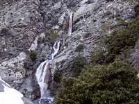
San Antonio Falls
From Manker Flat (Elev. 6165') follow the fire road where you will reach the San Antonio Falls in approximately 6/10's of a mile. The road makes a hairpin turn here so continue following it 3/10's of a mile. On the left side begin to watch for a steep use trail angling up the hill. It is unmarked and easy to miss. If this is your first time a watchful eye over your left shoulder should help spot the trailhead. A trail register can be found near the start indicating your on the right path.
Here you will begin a slow steady steep ascent of 2.5 miles before reaching the San Antonio Ski Hut (Elev. 8200'. The Ski Hut is a popular rest spot with plenty of trees. You have now reached the base of the Baldy Bowl. A popular destination during the winter months for back-country skiing and alpine mountaineering. For more information check the Baldy Bowl page.
The Devil's Backbone
From here continue left down across the stream following the use trail along the base of the bowl heading southwest across the boulder field. The trail will then begin to zig-zag up through the trees towards the top of the ridgeline topping out at approximately 8800'. Here the trail turns north towards the summit. Follow it for approximately .75 miles to the summit. Here you will have commanding 360 degree views and at times strong sustained winds.
Alternative Descent
Some hikers prefer to make a loop of their outing choosing to return via the Devils Back Bone Route. This will add approximately 2 miles to your trip. The good news is that this route concludes back at Manker Flat. Check here for route details.
Essential Gear
SPRING, SUMMER & FALL
Because of the elevation change and potential for strong winds being aware of the weather reports and being prepared will make the climb much more enjoyable. Layering is advisable for the changing elements. The only water source is the San Antonio Creek at the Ski Hut. Proper water purification procedures should be adhered to. This source may not be available in the late summer season depending on drought conditions. So bring plenty of water and stay hydrated. Once you gain the bowl ridge-line tree cover will be greatly reduced.
WINTER
The amount of snowfall will vary from year to year. If the conditions are fresh and deep, snowshoes would be advisable. Strong caution on the trail leading up to the Ski Hut is urged soon after new snowfall. Several of the steep chutes that the trail crosses are subject to avalanche. During the winter always carry crampons, an ice axe and helmet.
Also be mindful that winter weather is very cold on the summit as it is completely exposed. Sustained winds will increase the chill factor. Even experienced Mountaineers limit their time on the summit during the winter season.
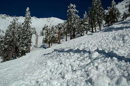 2005 Avalanche Debris Field. Picture by Steve Larson
spapagiannis - Sep 20, 2014 5:53 pm - Hasn't voted
Route clarificationA good note for first-time hikers on this route who are on decent: Around 1 mile from the top, when in the steep Class 2-ish section on the backside of the bowl there's a Manker Flats sign (with no arrow). The sign sits at a junction to a use trail which drops straight down from the main trail into Goode Canyon where there's a particular point of historical interest down there. This vertical use trail is NOT the correct decent route back to Manker Flats. There have been reports of people requiring SAR after continuing down Goode Canyon and becoming lost near the bottom, realizing this isn't the way out and not knowing how to get out. The sign was probably placed at this junction for this reason, but without any direction indicator it's not a helpful sign at all. So, when you see the sign on descent, keep heading on the nearly-level southward main trail that it parallels. NOT the vertical use trail.
stormj - Oct 26, 2016 2:56 pm - Hasn't voted
YupBack in '92 a buddy and I made that mistake on the way down and had to bivouac. It sucked. SAR was looking for us, but we walked out. Totally missed the planes there, which I didn't even know about at the time.