
|
|
Mountain/Rock |
|---|---|
|
|
32.87553°N / 107.77907°W |
|
|
Grant |
|
|
9660 ft / 2944 m |
|
|
Overview
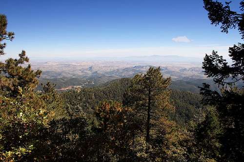
Sawyers Peak is located in the southern Black Range in southwestern New Mexico and lies within the borders of the Gila National Forest. The summit has an elevation of 9,660 feet and a prominence of 1,494 feet. The mountain sits in both Grant and Sierra Counties, but the summit itself is just inside the Grant County line.The trek to Sawyers Peak uses the southern section of the Black Range Crest Trail (Trail 79), located on the south side of New Mexico Highway 152. Unlike the northerly route to Hillsboro Peak which is chock full of scenic vistas, the southerly route to Sawyers Peak only has a couple of vistas which afford partially obstructed views to the east. Once you reach the summit of Sawyers Peak, it only gets worse -- due to the fact that it's below the treeline, the summit is totally devoid of any sort of scenic views.
Bear, cougar, bobcat, coyote, fox, deer, elk, javelina, ringtail cat, raccoon, wild turkey, Mexican Spotted Owl and Peregrine Falcon all inhabit the area.


Hiking & Camping
The Black Range Crest Trailheads (Trail 79) at Emory Pass (on NM Highway 152) provide the best access for the Black Range. This trail runs the length of the range along the central ridge. There is a large paved cul-de-sac parking area, tables, grill, and a pit toilet at Emory Pass Vista. The vista offers tremendous views to the east of the ghost town of Kingston, Hillsboro, Caballo Lake, and the mountain ranges beyond. Overnight camping is not permitted at the vista. The trailhead for the section of trail that heads north is located near the parking area entrance. The trailhead for the trail running south is on the other side (south side) of NM 152 across from the vista turnoff.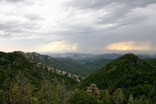
There are also many campgrounds, some with hiking trails, along NM 152 as it goes down Iron Canyon on the west side of the range. Because most of the range is almost entirely undeveloped, with the exception of those access points along NM 152, it can be very difficult to traverse this rugged terrain. See the External Links section for detailed resources for hiking and camping in the Gila National Forest. Primitive camping is also permitted along the trails in the range at no fee; no permits required.
Getting There
The 8,228-foot Emory Pass Vista provides the primary access to the Black Range. All directions below lead to this vista, where the Black Range Crest Trailheads are located.From the East: From Interstate 25, take exit 63 (Hillsboro exit) and go west on NM Highway 152. After traveling west for 27 miles you will pass through the small town of Hillsboro. 9 miles west of Hillsboro, you will pass through the even smaller town of Kingston. Continue 9 more miles past Kingston until you see the Emory Pass Vista, turn right and proceed about 0.15 miles until you see the paved parking area.
From the West: From Interstate 10 eastbound, take the Hwy 90 exit at Lordsburg and proceed north to Silver City. From there, take Hwy 180 for about 5 miles, then turn left onto NM Hwy 152 to head in a general easterly direction. At this point, you will be about 36 miles to Emory Pass Vista. Continue east on NM 152 until you see the vista, then turn left to reach the vista parking area.
From the South: From Interstate 10 in Deming, take US Hwy 180 north for about 1.2 miles, then veer right onto NM Hwy 26 and proceed northeast for about 30 miles. Turn left onto NM Hwy 27 at the “town” of Nutt Station, where you will see the “Middle of Nowhere Bar & Café.” After a short distance to the west, NM 27 will curve right and head in a general northerly direction. You will see the ghost town of Lake Valley to your right before finally reaching Hillsboro 18 miles later, where NM 27 ties into NM 152. Turn left at Hillsboro and head west on NM 152, passing through Kingston 9 miles later and reaching Emory Pass Vista 18 miles west of Hillsboro. Turn right at the vista and proceed about 0.15 miles to reach the parking area.
WARNING: Most of these roads are not well-traveled and there is open rangeland. Drive with caution and be wary of animals in the road.

Route to Sawyers Peak
Black Range Crest Trail (Trail 79): Trailhead is at Emory Pass (on NM Highway 152). There are two trailheads at the pass, one on each side of NM 152. For this route, use the trailhead on the south side of NM 152 (near the Emory Pass Historic Marker). Trail 79 is a well-maintained and easy to follow trail that uses multiple switchbacks. Follow Trail 79 south about 3.7 miles; the summit of Sawyers Peak will be to the west (right side of the trail). Detour off Trail 79 and it's an easy and safe bushwhack of roughly 0.3 miles and about 260 vertical feet to gain the summit. Proceed with caution -- there are barb wire fences in the area and sections of fenceline that have become detached from the posts and are on the ground pose a hazard. Refer to the GPS Coordinates section below for trail and detour position data. This route is about 4.0 miles each way with about 1,550 feet elevation gain.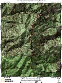 TOPO! map
NOTE: Topographic maps show a trail that branches off of Trail 79 almost due east of Sawyers summit and passes very close to the summit, but I didn't see it.
GPS Coordinates
The following coordinates may be helpful if you use GPS. The elevations below were taken from my GPS altimeter.| Waypoint | Elevation | Latitude | Longitude |
|---|---|---|---|
| Black Range Crest Trailhead (south section) | 8,115’ | 32.91007 N | 107.76637 W |
| Detour from Trail 79 to Sawyers Peak summit | 9,408' | 32.87408 N | 107.77547 W |
| Sawyers Peak benchmark | 9,665’ | 32.87541 N | 107.77914 W |
| Sawyers Peak summit | 9,670’ | 32.87553 N | 107.77907 W |
Red Tape
USFS regulations apply. For fees and other regulations, see the Gila National Forest links below. Backcountry hiking and camping do not require any permits. Remember to Leave No Trace.Food & Lodging
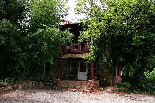
The historic mining town of Hillsboro is 18 miles east of Emory Pass on NM 152. This is the closest place to get food and gas, but don’t wait too long. Everything in the town -- including the gas station -- is closed by 7 pm. The S-Bar-X BBQ, at the gas station, is open from 11 am – 6 pm and has great BBQ brisket sandwiches. The Hillsboro Cafe closes its doors at 7 pm. I recommend you top off the gas tank before arriving in this area as the gas prices in Hillsboro are very high. For lodging in Hillsboro there is the Enchanted Villa Bed and Breakfast (telephone 505-895-5686).Nine miles west of Hillsboro (and nine miles east of Emory Pass) is the town of Kingston. Nestled in the foothills of the eastern Black Range, Kingston was once the premier metropolis of the New Mexico Territory, boasting a population of 7,000 in 1885. Today, it is a quiet community with about 30 residents. Aside from camping, developed or primitive, the nearest lodging is in Kingston at the Black Range Lodge bed and breakfast (telephone 505-895-5652). The original construction of the Black Range Lodge dates back to 1884 and each of the seven guest rooms are different and unique – there isn’t a bad room in the house! There are no restaurants, gas stations, or ATMs in Kingston.
Phone Numbers
Gila National Forest: 505-388-8201Gila National Forest - Black Range Ranger District (Truth or Consequences): 505-894-6677
External Links
Gila National Forest – Black Range Ranger DistrictGila National Forest – Hiking
Gila National Forest - Camping