|
|
Route |
|---|---|
|
|
46.06550°N / 7.69050°E |
|
|
Glacier/ Rock Climbing (Ridge) |
|
|
Half a day |
|
|
AD ( III ), G 5-6 |
|
|
Approach
You have to go to the town of Täsh and leave your car there or go to the camping just beyond the big parking area and the railwaystation. You have to cross the railway at your right side driving to the direction of Zermatt. You can take the train to Zermatt ( 15.6 CHF/pp) or you can take a taxi bus from the filling station at the other side of the road of the big parking area (5 CHF/pp to Zermatt). From Zermatt you follow the direction Trift and it will have to follow a steep road up to the Trifthotel. First you will pass the little café "Alterhaupt" 2961m that is visible from Zermatt.Then you pass the Trift hotel and it will take about another two and a half hours to reach the Rothornhut. It is a steep climb specially the second part from the Trifthotel over the moraine . The number of the Rothornhut is 0041(0) 279672043. The food is eminent !
Route Description
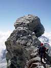
You start from the Rothornhut (3198m) and go to the right (E) in the direction of the glacier (3400m). You follow the steep rocks at your left till you come at a corridor (3480m) (avalanche activity in winter). There you climb up ('"wasserloch"12m). Fifteen meters at the end of corridor there is a big rock with a ribbon to make stand if you use a rope ( Climbing is III-). Then you go to the SW to another corridor (about 100 m away from the "wasserloch"), you climb this half the way and go further to the SW in a another corridor. At the top you follow the path (or the "steinmann" (cairns)) to reach a snowfield. You travers this field to the rockwall. Climb these rocks and you will come at a plateau ("Frustuckplatz") with brown rocks. There you go up to reach another snowfield en trtaverse this one to some lose rocks. You pass those rocks and you'll will reach the last snowfield to the rock corridor of the zinalrothorn. Climb or walk this snowfield till the snowridge and follow it till you reach the rocks.There you can leave some material depending on the conditions If you look up you'll see the "Gabel" at the end of the corridor. . At the beginning of the corridor you climb up the ridge on the right and reach a big rock at about 300 m. There you will travers the corridor to the left. At the beginning of those rock wall ( at the left side of the corridor) you'll will see some slings for a stand.That's the place for climbing up to the " Gabel" ( III-). Look out for stonefall due to other ropepartieswhen you travers . When you reach the "Gabel" you have to start climbing a little wall of rock at your right ( III-) (50 m). After passing a big rock on the right you'll will see the beginning of the travers called the "Binner Platte" . In good conditions it is very easy (III) but is is often covered with ice and that will make it delicate. After the "Binner platte" you have to climb straight up ( you can see the stand) over a blue fixed rope ( 8mm thick) to the top of the ridge. There you follow the ridge to the top. Before the top you have a little rock tower "Gendarm" and you have to cross it at his right side. After that it is obvious to the summit.
Essential Gear
You need a double rope (2X50m)
Some friends or camalots or nuts ( N° 1/2, 3/4,1,2)
6 Slings
Crampons
Piolet
Glacier rescue material
helmet
Miscellaneous Info
If you have information about this route that doesn't pertain to any of the other sections, please add it here.


Flachlandtiroler - Mar 31, 2006 9:06 am - Hasn't voted
Several...Train fee 15 CHF is the return ticket, bus 5 CHF is one way. The buses do not operate anymore late in the evening, the last train is at 23:20. The short piece "Wasserloch" IMHO should be rated UIAA I-II, for sure not III-. With wet conditions (name!) it might be II but regarding your pics the "wasserloch" should have been dry when you visited the peak. Where did you find the overall rating G5-6? On the main page G4-5 is mentioned and that is what I found in the Rother guidebook; the others do not use this scale.