
-
 20856 Hits
-
 77.32% Score
-
 10 Votes
|
|
Mountain/Rock |
|---|---|
|
|
40.48880°N / 76.5816°W |
|
|
1440 ft / 439 m |
|
|
Overview
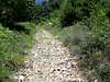
Second Mountain is another member of the great ridges that make up the south central mountains of Pennsylvania. Properly named because of its location in relation to Blue Mountain (the first ridge line as you head north from the Piedmont Region), Second Mountain has a concordant summit with that of Peters Mountain which is just to the north. Both of these ridges run for approximately thirty miles northeast to just south of Tower City, PA where they all meet like the spokes of a giant wheel. The geology of this area is quite impressive and the ridges that now stand are remnants of what used to be a coastal area.Now, the most interesting thing about Second Mountain…...That would have to be that it has one of the premier climbing areas in central Pennsylvania. Located at the extreme western end of the ridge, this area is known as the “Dauphin Narrows” and it scenically overlooks the Susquehanna River and Harrisburg, the capitol of PA. The only approach to the base of these large cliff outcroppings (pictures coming) is from the town of Dauphin, and you’ll have to take a short 0.3 mile jaunt along the railroad tracks. The cliffs hold many different routes from Class 3 all the way to the extremes of technical climbing.
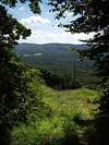
Views from different lookouts along this ridge are quite impressive, especially from the western end where you can get a good view of the Susquehanna River flowing south past the capitol of Pennsylvania in Harrisburg. Also, just another interesting fact, you can see the longest stone arched bridge in the world in the Rockville Bridge. This is best viewed from Dauphin Narrows. To the south you get views of the suburbs of Harrisburg and as you turn towards the southeast you’ll take in views along Blue Mountain. All other directions you look will take in views of the surrounding ridges which seem to run forever. When you look north towards the ridge of Peters Mountain you’ll be able to pick out the rock outcroppings of Table Rock and Shikellamy Rocks/Overlook.
This mountain has quite a variety in terms of trails and climbing which means there is something here to suite everyone. The views are descent and this mountain makes for an all around fun place to get away from it all and take in some nice central PA scenery, from wildlife to vistas.
Published Maps:
Keystone Trails Association: The Appalachian Trail map for sections 7 & 8 covers Second Mountain and shows all the trail systems on the mountain and many others in the area.
USGS 7.5 Quadrangles:
Duncannon Quad, Halifax Quad, Enders Quad, Grantville Quad, and Indiantown Gap Quad
 |  |  |
Technical Climbing
North Buttress, South Buttress (Lenoy Buttress):The two big climbing areas located in the Dauphin Narrows are named North and South Buttress (Lenoy Buttress). North Buttress is the shorter of the two and they both angle up south to north in an angle of about 60-70 degrees. Because of the protrusion from the mountain, large overhangs decorate the north sides of both buttresses creating some very technical routes.
I've never done any of the technical climbs on the buttresses, so I'm working on getting more information (and climbing them), but if anyone else has info they'd like to share it would be greatly appreciated.
For a little bit of information click on the link below which will take you to rockclimbing.com!
rockclimbing.com
 |
Getting There
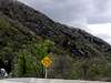
From Harrisburg, PA:To access this mountain from the Harrisburg area, take U.S. Rt. 322 west towards State College/Lewistown off of Interstate 81. From here head north along the river for about four miles until you reach the exit for Fishing Creek (PA Rt. 443). Take this exit and head east past Harrisburg Country Club. The mountain is on your left and there are numerous access points along this road which are described in greater detail in the route pages.
If you want to access Dauphin Narrows and the cliffs, continue past the exit for PA 443 until you reach the exit for Dauphin, which is only another mile farther. From here turn right as soon as you get off the ramp and find a place to park. You’ll have to walk to the base of the cliffs.
From State College, PA:
Take 322 East towards Harrisburg. Once you cross the Clarks Ferry Bridge you’ll need to start paying attention. Take the exit for Dauphin if you want to access the Dauphin Narrows and the cliffs which are three miles from the bridge. For the south side access continue for a mile to the PA 443 exit for Fishing Creek. Take this east to access the southern slopes of the ridgeline as the mountain will be on your left.
Red Tape
There are no permits or passes with fees required for use of this mountain and for trailhead access. Much of the ridge is part of Pennsylvania State Gamelands so there is no camping, but a lot of conservation is taking place in the area.When it comes to wildlife, the only concerns should be over bobcat and bear as they are fairly common to see in this area. There have also been rumors of "Bigfoot," but I've never seen one.
For general conservation purposes just follow the “LEAVE NO TRACE” program and you'll be fine as will the land you're using.
When To Climb
This mountain is climbable during all times of the year, but if you're on the part of the mountain within PA State Gamelands, you'll want to be careful in the Fall as this is hunting season. If you want to climb at Dauphin Narrows or hike out to the point at the west end of the ridge, you won't have to worry about that.The best times to hike on this mountain would be Spring, Summer, or early Fall. This could possibly make an interesting Winter outing as there are many trails that would be suitable for snowshoeing. The cliffs at the narrows are also good for dawning your crampons and ice axe when conditions are good. Every once and a while PA is fortunate enough to get some very cold conditions and at such times ice climbing is quite prevalent on the west end of the ridge.
Camping
There is no camping allowed on this mountain since much of it is under State Gamelands control.Mountain Conditions
For current and up-to-date weather conditions click on the link below!weather.com