
-
 4203 Hits
-
 81.18% Score
-
 13 Votes
|
|
Route |
|---|---|
|
|
Ice Climbing |
|
|
Winter |
|
|
Most of a day |
|
|
WI3-5 |
|
|
2 |
|
|
Overview
Skirmish and Cold War are actually two separate pieces of ice, but they're so close together that most people climb them both in the same day. Each is only one pitch long and the approach is arduous so it wouldn't make much sense to hike out and only climb one of them. These routes are not in the guidebook. Taken from below the bench, this shows the terrain.
Because of the high elevation (10,000 ft), these routes are always two of the first to form. But if you're coming straight from sea level, you might want to skip this approach.
THINGS TO CONSIDER
You need to be aware that this is a popular area for hunters during hunting season. Wear a bright orange hat or hang something orange from your backpack.
As with most of the South Fork, there are lots of grizzlies and mountain lions around. Don't assume the bears are hibernating because it's ice season. We've seen fresh bear scat in late December and an actual bear in February. Carry bear spray and make lots of noise.
Finally: I just want to emphasize that this is a long and sometimes brutal approach, all to climb one-pitch ice. It's only really worth the hike if you're dying to swing tools and nothing else is in. Depending on conditions and your level of fitness, it could take 3+ hours to reach the routes.
Getting There Part 1
From Cody, take the South Fork Highway. About 1.25 miles after you pass the large obvious rock formation known as Castle Rock, turn left onto Carter Mountain Access Road. The approximate UTM coordinates (NAD 27) for this road are 12T 0633228 4912519Follow the bumpy, washboarded road up many switchbacks until you reach a gate with a large obvious parking area on the right. The gate is usually closed on December 15th. There will often be horse trailers, pickup trucks or ATVs parked there. An even worse road branches off the main road at this point, going right. Follow that road until you see (on the left) a small pond with a fence through the middle of it. Up until 2012, you could turn left onto an even worse road and travel quite a bit further in a good 4WD vehicle. Now the Forest Service has closed that road to motorized access, so the hike is longer than ever. You'll see the old road on the left -- just park off the main road wherever you can. The approximate UTM coordinates (NAD 27) are 12 T 0636839 4905680.
 This picture was taken from the old parking area but you'll have pretty much the same perspective from the old road. The red arrow is NOT pointing directly at the routes. You have to keep hiking in that direction and the routes are past the edge of the picture.
WARNING: You need to have 4WD, chains and a shovel if you're going to drive up the Carter Mountain Access Road. Don't be fooled by snow-free conditions at the bottom of the road. The wind blows like crazy up there and big snow drifts will frequently block the way. We've had to dig out on three separate occasions and have chained up numerous times. There are no guard rails and in some places if you slide off the icy road you'll end up in a ravine.
CLOSURE: The road is now gated just past the parking area in January. You can hike/snowshoe up from the gate but only if you want a serious full-day workout.
Getting There Part 2
 One of the snow slopes up high.
Using the overview picture above, you should be able to figure out where you need to go. We've found that gaining the bench and walking across it to the routes is the easiest way to travel. If you try to take a more direct line, you'll end up in some pretty horrible terrain and may doom yourself to bushwacking through snow-drifted deadfall.
Depending on the year, there may be absolutely heinous snowdrifts between you and the bench and then snowshoes come in handy. Some years, we've hiked up there without snowshoes and been just fine. The bench is usually blown free of snow but there are a couple of short snow slopes to negotiate and they CAN avalanche. We set off a small slab last time we were up there.
The routes are down in a drainage below the bench and you'll be able to see Cold War long before you reach it. When you get there, rappel into the drainage.
Approximate UTM coordinates (NAD 27) are 12 T 0638093 4903674.
The Routes
Cold War (on climber's right after you rappel down) is the more interesting route because it's usually broad and has various lines from WI3 to WI5. Sometimes you can do a mixed line on it too. It's a good route for running laps or going up the easy side and top-roping the hard part for practice. Skirmish is a straight-up WI3 and you might find it in brittle condition. Skirmish Skirmish |  Cold War Cold War |
An Alternative
If the approach is kicking your butt, you can always change your mind and go climb November Pain instead (see overview picture for location). This is a short but steep WI5 that can be very chandeliered. But one year we did find it in WI3 condition, so you never know! You'll be able to see it from the road and as you hike up to the bench.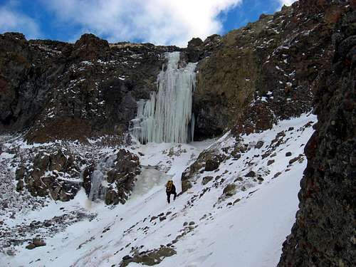 November Pain WI5
ANOTHER WARNING IN CASE YOU MISSED THE FIRST ONE
You need to have 4WD, chains and a shovel if you're going to drive up the Carter Mountain Access Road.