
|
|
Route |
|---|---|
|
|
44.30013°N / 118.62822°W |
|
|
Hiking |
|
|
Summer, Fall |
|
|
A long day |
|
|
1st step: Strawberry Campground to Slide Mountain
Starting at the Strawberry Campground head up the trail towards Strawberry Lake. There are many forks when heading for Slide Mountain, so be sure you follow these directions after leaving the campground and heading towards Strawberry Lake:1. Take the first left onto the marked Slide Basin Trail.
2. Shortly after the first fork take a left at Slide Lake sign.
3. Left at Big Riner Basin fork, head downhill towards Slide Creek.
4. Left at unmarked fork, still heading downhill.
5. Cross slide creek, head left down Slide Creek.
6. After a short distance take a right onto Skyline trail 385 at the base of Slide Mountain.
Below, a map showing trails and this route, view at original size to read

From here you will follow Skyline Trail up Slide Mountain's base until you can see the following cliffs above the trail as the forest begins to change to sagebrush. Here you want to head straight up the mountain towards the summit.
Below; once you see this cliff above the trail head directly for the chute in the middle and beyond towards the summit.

This route has roughly 3100 feet of elevation gain, and is a little over 5 miles one way.
2nd: Slide Mountain to Graham Mountain
From the summit of Slide Mountain head southeast along the ridgeline connecting to Graham Mountain. This is a low difficulty walk except for making your way up Graham's northwest butress seen below. I believe the easiest route is to circumnavigate the summit block to the right (south) watching above until you find a suitable path up mountains steep face. I found the further around Graham you travel, the easier access becomes to the summit. Circumnavigating Graham to the left (east) would be much more dangerous as the loose talus is steeper than the west side.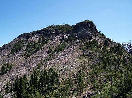
To return to Strawberry Campground head southeast from Graham Mountain to reconnect with Skyline Trail 385 which you can follow back to Slide Creek and retrace your route to the trailhead.

From Strawberry Campground to Graham Mountain has roughly 3700 feet of elevation gain and is about 6.5 miles one way.