
|
|
Route |
|---|---|
|
|
38.00600°N / 119.487°W |
|
|
Hiking, Mountaineering, Mixed, Scrambling |
|
|
Summer, Fall |
|
|
A few days |
|
|
Class 3 |
|
|
Easy |
|
|
Overview


Route Statistics
Elevation Gain: 1000ft
Distance: .5 miles
Getting There
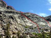
Volunteer Peak is located in a remote area of northern Yosemite and is usually climbed as part of a multi-day backpacking trip due to the distance involved in getting there. Follow the directions on the main Volunteer Peak page for the best options to reach this remote mountain. The SW Ridge ascent begins on the west side of the peak at the junction of the PCT and the Roger's Lake trail.Route Description
From the intersection of the PCT and the Roger's Lake trail, hike .2 mile south across the lightly forested meadow until you reach the granite slabs southwest of the summit. Pick a line up the granite slaps that you are comfortable with. The further to the right you climb, the easier the ascent. The granite slabs on the lower portion of the route are Class 3 for the most part.There is a large granite shelf above the slabs with a couple of tarns that look reasonably clean for drinking (assuming you have a water filter). From here you can either hike to the climber's right (east) and ascend the Class 2 sandy southern slope, or stick to the ridgeline for more enjoyable Class 3 climbing on rock. The ridgeline is steep here, but the initial buttress can be passed on either the left or right via a series of granite ledges that lead to another smaller shelf 100 feet above the first one.
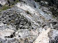
Above the second shelf, the SW Ridge consists of mostly large, stable talus. Those who like boulder hopping will enjoy the remainder of the ascent to the summit. Once again, the easier climbing is generally to the right and the more challenging climbing to the left of the ridgeline.