
-
 17832 Hits
-
 84.82% Score
-
 19 Votes
|
|
Mountain/Rock |
|---|---|
|
|
38.00600°N / 119.487°W |
|
|
Hiking |
|
|
Summer, Fall |
|
|
10481 ft / 3195 m |
|
|
Overview
Standing less than 10,500' in elevation, no more than an easy class 2 walk up by its usual routes, and with no reported technical routes, Volunteer Peak is neither a particularly high, difficult, nor especially reknowned peak by Yosemite standards. But what the peak perhaps lacks in height and climbing, it makes up for with superb views in one of the most scenic locales in the park. It may well be for this reason that it's earned distinction as one of three SPS listed peaks in the area. (Pettit Peak and Piute Mountain are the others).While the peak itself is an easy climb from Smedberg Lake, actually getting there qualifies as a bit of a challenge: Almost any practical approach to the area involves some 45 miles and 10,000 feet of gain, round trip. The peak has been climbed--in conjunction with nearby Pettit Peak--as a strenuous dayhike out of the Virginia Lakes trailhead, but the more popular option seems to be to climb Volunteer as part of a longer backpacking excursion through the area. I use the term "popular" somewhat loosely--despite its proximity to the Pacific Crest Trail, the summit sees just a handful of visitors each year, mostly SPS list seekers, augmented with a few others who no doubt found themselves intrigued by the peak's dramatically steep north face as they crossed Benson Pass for the first time.
The peak is most easily climbed from Smedberg Lake via a broad, grassy class 2 chute that leads up to the saddle just east of the summit; a short boulder hop leads from here to the highpoint. The summit can also be reached easily from Rodgers Lake to the south (class 2), or as a traverse from Pettit Peak (also class 2). The north and west faces are impressively steep, and even overhanging in places; the long approach and apparent technical difficulty of some of these lines will deter many climbers, but those who are sufficiently motivated (and fit) will undoubtedly find first ascent possibilities here.
 |  |  |  |
Getting There
To borrow from Dave K's Mt. Goddard page, if getting there is half the fun, you'll have a whole lot of fun climbing Volunteer. The primary trailhead options are as follows (consult a map of the park, or the Eastern Sierra Logistical Center for trailhead driving directions):| Trailhead | Statistics (one-way) | Notes |
| Saddlebag Lake (via McCabe Pass/Benson Pass) | 22 miles (+5400', -5000') | McCabe Pass is class 2. |
| Virginia Lakes (via Summit Pass/Benson Pass) | 23 miles (+5800', -5100') | |
| Twin Lakes (via Mule Pass/Burro Pass/Benson Pass) | 26 miles (+7600', -4200') | |
| Hetch Hetchy (via Pleasant Valley/Rodgers Canyon) | 28 miles (+8600', -1900') |
The Virginia Lakes trailhead may be the easiest option overall, as the entire approach is on good trail. Keep in mind that easiest is relative: It involves crossing Summit Pass, dropping down to Virginia Canyon, then up and over into Matterhorn Canyon, then up and over Benson Pass to Smedberg Lake. Particularly interesting is that--despite the fact that the trailhead elevation is only 700' lower than the summit of the peak--the round trip gain from Virginia Lakes is close to 11,000 feet!
Although longer, the most scenic option of the four listed here is (by far) the approach from Twin Lakes; this passes several beautiful lakes and some spectacular meadows.
If climbing Pettit Peak as well, returning via Rodgers Lake, add about 4 miles and 1200' gain to the round trip statistics.
A final note: In principle, Pettit Peak could be used as an approach to Volunteer Peak. This is worthy of mention because Pettit can be reached from Tuolumne Meadows via Return Creek with substantially less mileage and gain than the aforementioned approaches; consult that page for details on this approach. However, this option involves some arduous cross-country travel, and most will find the longer trail approaches more pleasant.
Red Tape, Conditions, etc.
Backpackers are required to carry both a wilderness permit and a bear cannister. For entry via Hetch Hetchy, consult the Tuolumne Meadows Logistical Center for details about Yosemite wilderness permits. (The permit can be picked up from any ranger station in the park, including the western entrance station along Hwy 120). Approaching the peak via Saddlebag Lake, Virginia Lakes, or Twin Lakes begins in the Hoover Wilderness, and would require obtaining a permit from Inyo National Forest; refer to the Eastern Sierra Logistical Center for details. (Note that the trailheads used to access this peak aren't particularly popular, and day-of-hike permits are generally easy to obtain--it's typically not worth reserving them ahead of time).For information on current conditions, please refer to either of the preceding logistical pages.
When To Climb
The long approach makes this peak an impractical proposition for most people in winter/spring, and consequently it's generally climbed during the summer and fall months (typically June-October). Much of the approach to this peak is at fairly low elevation, and tends to melt out relatively quickly, but a visit in the fall may be preferred; the deep canyons of northern Yosemite can be uncomfortably warm during the height of summer.Camping
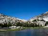
The terrain around the peak is fairly gentle and consists of many small meadows and slabs, allowing for camping almost anywhere. Popular spots are found around Smedberg Lake (this lake is one of the few exceptions to the rule that solitude may be found in northern Yosemite), and Rodgers Lake.Etymology
The peak was named by the USGS in 1911: "Replaces the former name, Regulation Peak, which was given by Lt. H. C. Benson in 1895 and transferred by mistake to another peak by the USGS."- Erwin Gudde, California Place Names