
|
|
List |
|---|---|
|
|
Overview
The Emblem Peaks were designated by the Sierra Peak Section (SPS), a section of the Angeles Chapter of the Sierra Club, as part of a larger list of Sierra peaks starting in 1955. The first list, proposed by Frank Sanborn, the first chair of the SPS, contained 100 peaks. Miles Brubacher, the first chair of the Mountaineering Committee, added to this list and compiled the first list of qualifying peaks around November 1955. It had 200 peaks on it with 10 Emblem Peaks. The present list of 248 peaks, unchanged since December 2007, now has 15 Emblem Peaks.The Emblem Peaks were so designated because they dominate the area by their bulk or the amount of terrain that can be seen from the summit. All are over 12,000 ft in elevation, and span the High Sierra region from northern Yosemite to south of Sequoia National Park. Most were named by the Whitney Survey party in the 1860s, and three of them are named after members of that party (Whitney, Brewer, and Clarence King).
The Peaks
| Matterhorn Peak Matterhorn Peak lies on the northern boundary of Yosemite NP, the highpoint of the impressive Sawtooth Ridge. This is considered the northern extent of the High Sierra, and there are no higher peaks north of Matterhorn in the entire Sierra Nevada. The North Arete is considered a classic rock climb. The peak was made famous by Jack Kerouac who wrote about climbing the peak in his 1958 book, Dharma Bums |  |
| Mt. Lyell The highpoint of Yosemite National Park, Mt. Lyell is home to one of the largest glaciers in the Sierra Nevada. Though not considered a difficult climb by most standards, the peak was declared "inaccessible" by the Whitney Survey Party when it was first attempted in 1864. Mt. Lyell can be seen from almost every summit within the park boundaries. | 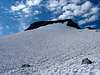 |
| Mt. Ritter Mt. Ritter is considered the most widely recognizable peak from the summits of other peaks in the range. It stands as the highpoint of the Ritter Range, an ancient volcanic formation much older than the more common granitic regions of the Sierra. The summit was first climbed by John Muir as vividly described in his book, The Mountains of California. |  |
| Mt. Abbot Mt. Abbot lies along the Sierra Crest in the Little Lakes Valley area between Mono and Morgan passes. It is a challenging peak, class 3 by its easiest route, flanked on either side by the similarly impressive peaks of Mt. Dade & Mt. Mills. Of all the Emblem peaks, Mt. Abbot has the shortest approach, making it easily doable as a dayhike by most climbers. |
 |
| Mt. Humphreys This is the impressive peak with a distinctive summit seen in the distance from the nearby town of Bishop. It dominates the Humphreys Basin area, extending from Piute Pass to Pine Creek Pass. All of its routes are challenging. It was first climbed in 1904 by James Hutchingson and his brother. Two companions with them failed to reach the summit, stopping at a particularly difficult juncture along the route that came to be known as Married Men's Point. | 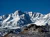 |
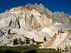
| Mt. Darwin Mt. Darwin stands as the monarch of the Evolution region, a chain of peaks on the northeast boundary of Sequoia-Kings Canyon NP named by Theodore Solomons on his exploratory journey through the region in 1895. The high peak's distinctive summit plateau is easily recognized from great distances throughout the range. The highpoint is a challenging pinnacle detached from the main plateau. |
 |
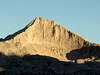
| Mt. Goddard Mt. Goddard is one of the more remote peaks in the range, located in the upper reaches of the Sequoia-Kings Canyon NP. Lying a good deal west of the Sierra Crest, the summit provides an expansive view of the Sierra Crest from the Mammoth Lakes area to south of Mt. Whitney. The peak is composed of endless talus on its easier slopes, and dangerously loose rock on the steep Northwest Face - it is generally not considered a good climb for anything other than the views. |
 |
| North Palisade North Palisade is considered the classic peak in the Sierra Nevada. It is the tallest peak in the Palisade region, a high, rugged series of impessive peaks between South Fork Pass and Bishop Pass. This region was home to the Palisade School of Mountaineering in its day, a legendary organization that taught a generation of climbers the skills of the trade in the High Sierra. On the north side of the peak lies the largest glacier in the Sierra Nevada. Above this, the U-Notch Couloir is considered the classic route to the summit of North Palisade. |
 |
| Split Mountain Split Mountain's distinct double summit towers just over 14,000ft along the Sierra Crest just south of the Palisade region. At one time it was called South Palisade and considered part of the same group. It is one of the easier of the Emblem peaks to climb, but boasts some impressive ice couloirs on its northeast side. |
 |
| Mt. Clarence King Named for the charismatic member of the Whitney Survey Party, Clarence King rises high on the crest between Gardiner Basin and Rae Lakes, west of the Sierra Crest. Bolton Brown had the honors of making the most difficult Sierra ascent of the 19th century with his ascent of the 5.4 summit block in 1895. Clarence King wrote a popular book called Mountaineering in the Sierra Nevada in which he detailed his exploits (with significant poetic license) in the range, including his attempts to be the first to climb Mt. Whitney. |
 |
| Mt. Brewer At the time of its first ascent by its namesake William Brewer and party (of the Whitney Survey party), it was believed to be the highest peak in the range. From its summit, these hardy surveyors spotted and named Mt. Whitney, the true highpoint, some distance to the southeast. Lying a considerable distance from the Sierra Crest at the northern end of the Great Western Divide, Mt. Brewer has a commanding view of the crest and the surrounding areas of the Sequoia-Kings Canyon NP. It has one of the greatest elevation gains above its nearest trailhead in the range, nearly 9,000ft from Cedar Grove. |
 |
| Mt. Williamson As the second highest peak in California, Mt. Williamson receives only a fraction of the visitors of Mt. Whitney. It is known mostly to climbers, though it is one of the most prominent peaks viewed from the Owens Valley in the vicinity of Independence and Lone Pine. No climb of Mt. Williamson is trivial, and visits are restricted due to Bighorn Sheep closures during much of the year. This is the only Emblem peak that lies east of the Sierra Crest. |
 |
| Mt. Whitney Mt. Whitney is the highest peak in the continental US. Because of this, a trail was completed to the summit in 1904 to accomodate the hoards of climbers wanting to reach its summit. A tramway was proposed back in 1926 that was never built. Despite having been reduced to a long hike, the peak boasts some impressive technical routes on its eastern escarpment, including the East Face Route first pioneered by legendary climbers Underhill, Clyde, Eichorn, and Dawson in 1931. |
 |
| Mt. Kaweah Mt. Kaweah stands as the highpoint of the Kaweah Range, an offshoot of the Great Western Divide. It lies west of the Kern River and the Sierra Crest in the southern portion of the Sequoia-Kings Canyon NP. The peak has no significant technical challenges in reaching its summit, but its location at the center of the widest section of the Sierra Nevada makes it the most arduous to reach of all the Emblem peaks. |
 |
| Olancha Peak Olancha Peak is a prominent peak in the southern part of the range near the town of Olancha in the Owens Valley. Its lies atop the Sierra Crest with a very steep escarpment on its east side, making it visible from almost everywhere in the southern part of the valley. It is the most southern peak in the state to rise over 12,000ft in height. |
 |