
|
|
Mountain/Rock |
|---|---|
|
|
46.28810°N / 10.35579°E |
|
|
Hiking, Mountaineering |
|
|
Spring, Summer |
|
|
11076 ft / 3376 m |
|
|
Overview
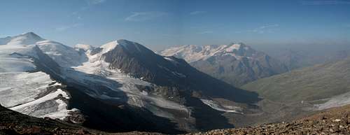
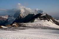
Suldenspitze (in Italian Cima Solda) is located in the Stelvio National Park in Italian South Tyrol and part of the Ortler - Cevedale Group.
Stelvio National Park the largest in the whole Alpine chain. It stretches in the heart of the Central Alps and includes typical valleys shaped by the action of ice and water flowing down from the imposing massif of the Ortles-Cevedale group.
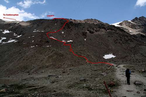
From the summit at 3376 m high you have great views on Cevedale, Gran Zebru and Ortler. In summer, it's an easy non - technical ½ hour walk from the Rifugio Casati. In winter/spring It's also "climbed" by alpinist-skiers.
Getting There

To get to the mountain you have to choices:
- by BORMIO, from there it is a 12km ride to Santa Caterina Valfurva and
from there another 8 km up to the rifugio Ghiacciaio ai Forni where you can
park your car.
- SULDEN/SOLDA,located on the other side of the 2757 meter high Stelvio
mountain pass (only open in summer).
Route
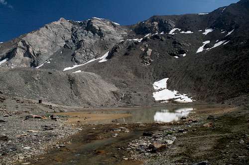
Bormio side: from the parking at the rifugio Ghiacciaio ai Forni at 2200 m you walk on an easy broad trail in about two hours to Rifugio Pizzini at 2706 m. From Rifugio Ghiacciaio ai Forni you can also go up to Rifugio Pizzini by 4 wheel drive. From Pizzini it is another 1 ½ to two hours on a sometimes steep and narrow walking trail to Rifugio Casati at 3269 m. From Casati it's only an ½ hour walk up to the summit.
Sulden side: From Sulden/Solda at 1924 m you walk up to Rifugio Città di Milano/Schaubach-hutte at 2573 m in about 2 hours. You can also take the cabin lift. From there you cross the Sulden-glacier and walk up to Rifugio Casati or directly to the Suldenspitze which will take about 2 ½ hour.
When to climb
The best time to climb it is summertime (July till September) although if
you are a ski-mountaineer you should chose winter of spring.
Red Tape
Parco Nazionale dello Stelvio is 134.620 ha big, and elevation ranges from 639 up to 3905 m (Ortler summit).
You don't need any permits, there are no fees to be paid.
Gear
If you start at rifugio Ghiacciaio ai Forni, you don't need any special gear in summertime to get to the summit.
Coming from Sulden you need to cross the glacier so you'll need rope, crampons and ice axe.
Camping
Within the National Park, no camping is allowed. There are plenty of beds in the different refuges.
The nearest camping in the valley is in Valdisotto, 5 km from Bormio: Cima Piazzi
Refuges
Rifugio Casati
Ghiacciaio ai Forni
Rifugio Milano
Maps
Freytag Berndt Wanderkarte WKS6 (1:50.000) Ortleralpen - Martell - Val
di Sole
Tabacco 08 Ortles Cevedale - Ortler - Sulden - S. Caterina Valfurva
(1:25.000)
Weather info
Check out the weather at Bormioonline