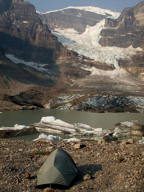
![Expedition routes]() Three expedition routes that I travelled in the Mount Sir Alexander area in 2007, 2008 and 2009
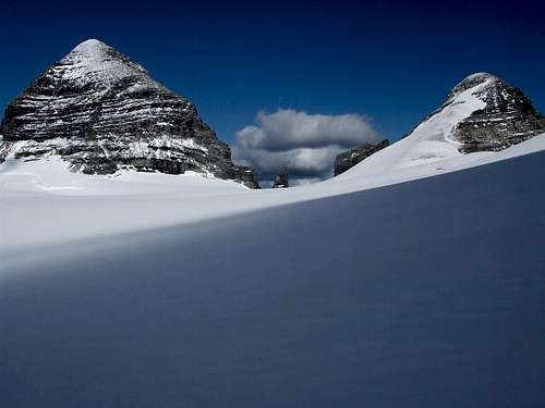
Three expedition routes that I travelled in the Mount Sir Alexander area in 2007, 2008 and 2009![High camp at the top of the Kitchi Icefield.]() Leaving camp to go do my business.
Leaving camp to go do my business.![Back to the castle]() Back to the castle.
Back to the castle.
August 14, 2009: Camp 8 had been established at 2750m (9000ft) elevation on the highest plateau of the Kitchi Icefield, just far enough from the massive Southwest wall so the rocks that often crash down the mountain wouldn’t obliterate the tent. I crawled out before breakfast to go crap. Being a conscientious mountaineer, I walked in blowing snow for five minutes to do my business under rocks. After I was done, I turned around and a whiteout fog had made the campsite vanish, and my tracks were obliterated! I advanced into the white void, vaguely going upwind while hard snow crystals whipped into my eyes. When I was sure that I had gone too far, I retraced my steps back to the rocks. “You idiot, you should have brought the compass!” I tried another direction, then another, until finally a faint shape materialized on the fourth wandering. PHEW! Back to the castle.
This was not to be summit day. That was expected so I had enough food to wait a full week. The weather conspired to force me to read a book about some personal issues and do the ”prescriptions for self-care” for four days. I also had the article by Dr. Andrew Gilmour about the first successful ascent of Mount Sir Alexander in 1929. After a tree-week approach from Jasper, including waiting five days at base camp, he and fellow Americans Miss Helen Buck and Mr. Newman Waffl ascended a terrifyingly steep couloir on the West face, but they saw ledges that looked safer on the Southwest face. Ahaaa, thanks for the clue.
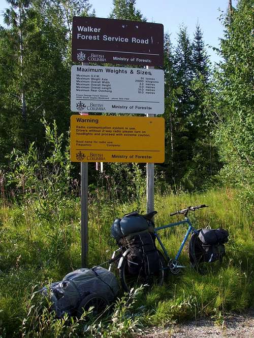
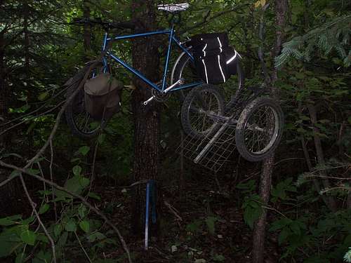
This was my third expedition to Mt. Sir Alex, the most massive peak in Kakwa Provincial Park, British Columbia at 3275m (10745ft) in elevation. This peak, 81km (50mi) West of Grande Cache, Alberta as the raven flies, is surrounded by glaciers and looms over huge bastion-like walls. Last year, an impassable icefall foiled my attempt to access the Southwest face, which is the only sane solo route up this monster. I soloed because I couldn’t find anyone who could take a month off, with whom I wanted to spend days on end waiting in a cramped tent, and who wanted to do the approach “in good style”, as mountaineer Craig Evanoff called it. I parked 60km (37mi) Northwest of McBride, B.C. in the tiny community of Crescent Spur, at an acreage owned by the wonderful Gabert family who operate the Outdoor Life Adventure Co. By the Fraser River, I loaded up the mountain bike and trailer for a total of 80kg (175lbs) of gear and supplies for 27 days. I cycled 90km to and on the Walker Forestry Road, where I told the road improvement crews about my aspiration. In the Middle of Nowhere, I hung the bike and trailer on trees to protect them from rubber-nibbling porcupines.
![Walker Forest Service Road]() Beginning of the Walker Forest Service Road, with Mountain bike and trailer.
Beginning of the Walker Forest Service Road, with Mountain bike and trailer. ![First sighting of Mount Sir Alexander]() First sighting of Mount Sir Alexander.
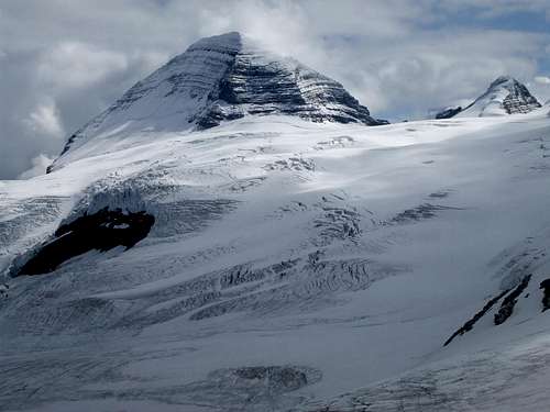
First sighting of Mount Sir Alexander.![Pass NW of Pommel Mountain]() This pass, NW of Pommel Mountain, accesses the Kitchi Icefield on Mount Sir Alexander.
This pass, NW of Pommel Mountain, accesses the Kitchi Icefield on Mount Sir Alexander.![Bike and trailer on trees]() I hung the bike and trailer on trees to protect them from rubber-nibbling porcupines.
I hung the bike and trailer on trees to protect them from rubber-nibbling porcupines.
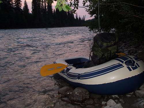
Then the fun began: bushwhacking with 43kg (95lbs) of gear through old logging slash, where you rarely see the actual ground because it’s covered in spiny Devil’s Club growing in between logs on top of logs. Then I inflated the dinghy, crossed the swift McGregor River, and hung it with the paddles in a tree. After a 1200m (4000ft) bushwhack up through virgin forest to the pass Northwest of Pommel Mountain, I was overjoyed with an awesome vista of the vast Kitchi Icefield and a clear view of my mountain obsession, so close that I could “reach out and touch it”. I was startled to see a grizzly coming down a glacier in my direction, weaving around crevasses. What the… is he doing up here? There’s nothing to eat...Oh oh, he smelled the supper I was cooking? I scrambled to the tent to get my camera and a plastic bag to put the pot in, but he loped down the pass as soon as he saw me.
![Dinghy to cross the swift McGregor River]() I inflated the dinghy to cross the swift McGregor River.
I inflated the dinghy to cross the swift McGregor River.![Class 9 bushwhacking]() Class 9 (on a scale 1-10) bushwhacking to get up the pass NW of Pommel Mountain.
Class 9 (on a scale 1-10) bushwhacking to get up the pass NW of Pommel Mountain.![Pass Northwest of Pommel Mountain]() Treeline at the pass NW of Pommel Mountain.
Treeline at the pass NW of Pommel Mountain.![Vista of my mountain obsession]() Awesome vista of my mountain obsession, so close that I could “reach out and touch it”.
Awesome vista of my mountain obsession, so close that I could “reach out and touch it”.![Massive Kitchi Icefield crowned with Mount Sir Alexander]() Massive Kitchi Icefield crowned with Mount Sir Alexander.
Massive Kitchi Icefield crowned with Mount Sir Alexander.
After submerging my sleeping pad in a puddle to locate a pinhole leak, I snapped on the crampons and lumbered up the icefield, probing every step for hidden crevasses. At the top of this wonderland, I bombproofed the tent at high camp. The southwest face looked difficult, but better than all the other faces I had seen on the two last attempts. It’s a giant staircase with about 14 steps, or ledges, conveniently angled 20 degrees toward talus rocks on the South ridge.
![Lumbering up the icefield]() Lumbering up the icefield.
Lumbering up the icefield.![SW face of Mount Sir Alexander, with the tower and Nilah peak]() Very close to the SW face of Mount Sir Alexander, with 'the tower' and Nilah peak to the right.
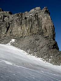
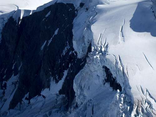
Very close to the SW face of Mount Sir Alexander, with 'the tower' and Nilah peak to the right.![Rocks that often crash down the the Southwest wall.]() Rocks that often crash down the the Southwest wall.
Rocks that often crash down the the Southwest wall.
Three-frame panorama of the SW face of Mount Sir Alexander.
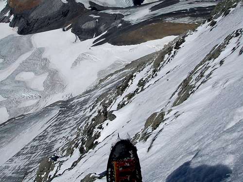
Five days later, the morning of August 19th was delightfully clear. Crampons on, up the glacier. Crampons off, up talus. Crampons on, ice-climb a couloir using both ice tools. Crampons off, start up ledges. The cliffs between the ledges are 2-5m (6-15ft) high. I zigzagged on the ledges for hours to find weaknesses for the safest ascent of each cliff. But there was one cliff that had NO safe way up. The best option was a vertiginous rock climb, and I was wearing hard plastic mountaineering boots. So I asked my inner guide “Should I climb this cliff?” and he answered: “If you don’t climb this cliff, you’re going to kill yourself.” I promised myself that it would be the last cliff of this exposure that I would climb. So up I went, slowly choosing handholds and footholds and chimneying up. At the top, I planted another bamboo wand with flagging tape, and GPS’ed its position to mark the way back down this maze. To my great relief it turned out to be the crux of the expedition. With increasing excitement, I climbed the remaining ledges to the loose talus on the South ridge. Once there, I thought there would be no more difficulty. With exhilaration, I reached the icy summit ridge, but Alex had another surprise: the ridge is a knife-edge that only a mouse can walk on, and the summit is 400m (1300ft) away horizontally. Crampons on, start the long ice-climb traverse, front-pointing on the 50-degree slope, going sideways.
![Bamboo wand to mark the way back down this maze]() I planted another bamboo wand with flagging tape, and GPS’ed its position to mark the way back down this maze.
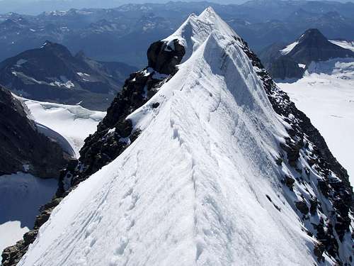
I planted another bamboo wand with flagging tape, and GPS’ed its position to mark the way back down this maze.![Icy summit ridge of Mount Sir Alexander]() I reached the icy summit ridge, but Alex had another surprise.
I reached the icy summit ridge, but Alex had another surprise.![Summit ridge of Mount Sir Alexander is a knife-edge]() Alex had another surprise: the summit ridge is a knife-edge that only a mouse can walk on. My crampon and boot tracks are on the left. Looking SW.
Alex had another surprise: the summit ridge is a knife-edge that only a mouse can walk on. My crampon and boot tracks are on the left. Looking SW.
Just below the summit, I was disappointed that I couldn’t stand on it. Well duh, I could sit on it! So I proceeded to chop a saddle on the knife-edge with the adze of the ice axe. I mounted the mountain, and sat with one leg dangling on each side of the 600m (2000ft) drop-offs. Unbelievable! But no joy-yells came out. This was the first time that worry about descending a mountain tempered my summit joy, and I’ve been around. This was definitely the most difficult and dangerous climb of my life, harder than Mount Robson. I planted the ice axe and hung my pack on it. After many photos, the summit yahoos finally came. I took out my offering to the mountain, a five-gram pellet of pure iridium metal, and dropped it down a hole in the ice. It’s the most corrosion-resistant metal known, and is very hard, so the pellet could last millions of years, possibly longer than the mountain itself; mind-boggling. I felt very satisfied to recognize much of the magnificent scenery below, from exploring the area over the years. The prominent landmark is beautiful Mount Ida (3189m; 10462ft), 15km (9mi) away. Maybe a future climb? I was astounded to see Mount Robson 120km (75mi) away, the only higher peak in the panorama.
![Chopped a saddle and mounted the mountain]() I could not stand on the knife-edge of the summit, so I chopped a saddle and mounted the mountain.
I could not stand on the knife-edge of the summit, so I chopped a saddle and mounted the mountain.![One leg dangling on each side of the drop-offs]() One leg dangling on each side of the 600m (2000ft) drop-offs.
One leg dangling on each side of the 600m (2000ft) drop-offs.![Ultimate high after three years effort!]() Ultimate high after three years' effort!
Ultimate high after three years' effort!![My offering to the mountain]() My offering to the mountain: a five-gram pellet of pure iridium metal.
My offering to the mountain: a five-gram pellet of pure iridium metal.![Looking NE on the summit ridge]() Looking NE on the summit ridge
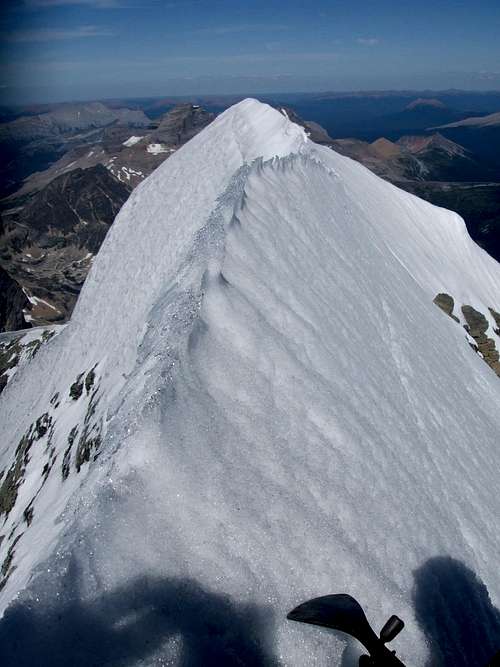
Looking NE on the summit ridge ![Monster wall!]() Monster wall!
Monster wall!![Kitchi Icefield showing route around Pommel Mountain]() Kitchi Icefield showing route around Pommel Mountain.
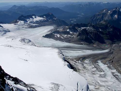
Kitchi Icefield showing route around Pommel Mountain.![Two main branches of the Kitchi Icefield.]() View from the summit, showing the two main branches of the Kitchi Icefield.
View from the summit, showing the two main branches of the Kitchi Icefield.![Beautiful Mount Ida]() Beautiful Mount Ida, maybe a future climb?
Beautiful Mount Ida, maybe a future climb?
After only a half-hour of sitting on the summit, it was time to face the descent. True to my worries, a one-foot-wide rock that I had disturbed came rolling down the loose talus slope, hit my foot, knocking me down on my back and elbows. Then I heard the sickening sound of another rock crashing down the slope before I could get up. This second one-foot jagged rock bulldozed my arm, chest and thigh. Adrenaline kicked in and I sprung up and away. In pain, I checked myself and to my great relief, I only had bruises, a sore hip ball joint and gashes in my clothes. PHEW!!! The rescue beacon will not be used. Shaken but determined, I descended the ledges, which oddly were easier to down-climb because of the bracing that was possible. It was much faster going down because the zigzag route was already marked with the four wands, which I retrieved. The little green dot on the icefield got bigger, then I arrived “home” after sunset on this epic 14-hour climb. It had been so warm that the snow had melted around the tent, so it was perched on a pedestal with the poles drooping down, requiring much propping.
![Tent perched on a pedestal]() The tent became perched on a pedestal.
The tent became perched on a pedestal.
The mountain wanted to keep me there; barely ten minutes into the return journey, a thunderstorm moved in, obliterated visibility, zapped lightning around, and dumped hail and wet snow. I refuse to do glacier travel in a whiteout, so I dropped the pack and walked in a holding pattern around it to keep warm. I expected a break, but hours later it just got worse, so I had to put the tent back up and do endless mopping up with a rag. In the morning, everything was frozen, so I had to chop the ice around each stake to get them out.
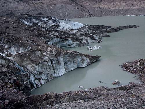
I found an astounding peculiarity at the Kitchi terminus lake: water gurgles through the lake bottom, then gushes straight out of a 4m (12ft) high hole in the canyon wall. After 17 days, I crawled out of the bush and back on the forestry road. News about me spread amongst the road work crew. After digging up the food cache, I was compelled to visit Shangri-La, at the base of the highest icefall on Sir Alex, a 1200m (4000ft) drop. I cycled to the end of the road, then continued on the “Tote Road” trail, waded across the Buchanan Creek, then bushwhacked to this mountaineer’s paradise. Ice frequently crashes down in a thunderous roar, and the glacier splits into icebergs, which float all over the kilometre-wide (0.6mi) lake. I had seen it from above last year, but it did not exist on satellite images only three years old. So it’s a new lake and there’s a high chance that I discovered it. I named it Lake Shangri-La Lake, after James Hilton’s Lost Horizon, about a utopian community in the Himalayas. Maybe I’ll register it with the Geographical Names Board of Canada. I climbed as close as safely possible to the impact zone of the icefall, to experience its power.
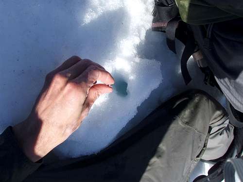
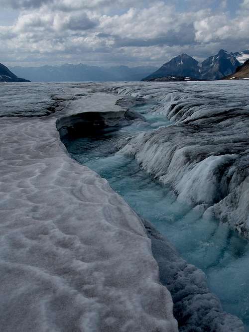
![Ethereal blue stream on the Kitchi Icefield.]() Ethereal blue stream on the Kitchi Icefield.
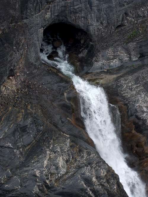
Ethereal blue stream on the Kitchi Icefield.![An astounding peculiarity at the Kitchi terminus lake]() An astounding peculiarity at the Kitchi terminus lake: water gurgles through the lake bottom, then gushes straight out of a 4m (12ft) high hole in the canyon wall.
An astounding peculiarity at the Kitchi terminus lake: water gurgles through the lake bottom, then gushes straight out of a 4m (12ft) high hole in the canyon wall.![Close-up of the river s resurgence from the wall]() Close-up of the river's resurgence from the wall.
Close-up of the river's resurgence from the wall.![The road to Shangri-La]() The road to Shangri-La.
The road to Shangri-La.![The highest icefall on Mount Sir Alexander]() The highest icefall on Mount Sir Alexander. It drops 1200m (4000ft) down the East wall.
The highest icefall on Mount Sir Alexander. It drops 1200m (4000ft) down the East wall.![My Shangri-La!]() My Shangri-La!
My Shangri-La! ![Ice frequently crashes down in a thunderous roar.]() Ice frequently crashes down in a thunderous roar.
Ice frequently crashes down in a thunderous roar.![As close as safely possible to the impact zone of the icefall]() As close as safely possible to the impact zone of the icefall, showing new blocks of ice.
As close as safely possible to the impact zone of the icefall, showing new blocks of ice.![I named it Lake Shangri-La]() It’s a new lake and there’s a high chance that I discovered it. I named it Lake Shangri-La.
It’s a new lake and there’s a high chance that I discovered it. I named it Lake Shangri-La.
Wrapping up the journey, I visited Kakwa Lake, where two correction officers had guided two inmates on a backpacking trip, a reward for good behaviour. After the 25-day human-powered expedition, I was back in Crescent Spur, where I was treated like a king at the Gabert’s beautifully preserved railway-boom period house. It was wonderful to share stories and photos, and to spend time with the children who showed me around and made drawings for me.


Comments
Post a Comment