
|
|
Route |
|---|---|
|
|
40.38460°N / 111.636°W |
|
|
Hiking |
|
|
Spring, Summer, Fall |
|
|
Most of a day |
|
|
Overview
 Primrose Cirque, seen from the Timpanogos (Harstky) Loop on Roberts Ridge
The Timpanogos Loop consists of three main trails: the Timpooneke Trail to the summit of Mt. Timpanogos, the Aspen Grove Trail down past Emerald Lake and into Primrose Cirque, and, at a point just below the talus on the Aspen Grove Trail, the Hartsky Trail, an umimproved abandoned trail named after Paul Hart, who rediscovered it. These three trails together create a loop hike to the summit of Mt. Timpanogos.
Getting There
Follow the instructions to the Timpooneke Trailhead. If parking is tight (that is, after 0530 on any Saturday morning, continue up the Alpine Loop to either of the pullouts where the loop crosses the road, or all the way to Loopcrest (the summit of the Alpine Loop). From there you can downhike the loop back to Timpooneke.Route Description
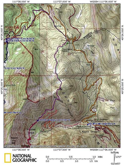 Route Map
After the drainage the trail contours on a wide limestone shelf, crossing a second drainage. After another half a mile you will encounter a wet area. Look to the left, at the water source. You will find a piped spring. The water is pure, delicious, and easily accessible (watch for nettles in the height of summer). Soon the trail shoots east to Roberts Ridge, where the views are unreal, north and south. Some rough campsites are on the ridge. If you don't mind hucking water from the spring you could spend days here.
The trail crosses Robert's Ridge and becomes even more distinct. After some whoop-de-doos it descends abruptly into upper Horse Flat Meadow. The trail braids a bit here. Go down, north. All the braids will converge in the meadow. You will see a big rock pile in the meadow, and a very well defined trail coming in from the northwest. Follow this trail. It crosses a moraine (glacial hillock), and then you will see the Forest Service sign for Horse Flat. Continue north and down and wind through the aspen and firs. You will soon come to another meadow, and a new forest service carsonite trail sign for a trail turning left (west). You now have a choice. You can take the trail marked by the carsonite. This is a redux of the old Elkshit Spring Trail (the name is not mine--it figures on an aspen next to the spring). This will take you down to the Alpine Loop across from an old gated service road, where you will junction with the Great Western Trail. Or, instead of the Elkshit Spring Trail, you can go straight, which will lead you past the Timpanogos Divide snotel weather station and, eventually, Loopcrest. From there you take the Great Western downhill (northwest) to a road crossing, through Salamander Flat, and then to the service road gate where the new FS trail comes in. From here just follow the GW down, down, down to Timpooneke and the start.