Uncompahgre Peak
Via Nellie Creek TH
Saturday July 12, 2008
I had climbed Wetterhorn Peak earlier in the day, stopped at Henson Creek to take a “bird” bath and then into the town of Lake City for a cold beer at the Packer Grill. The day was hot and clouds were building a bit as I went over to Lake San Cristobal to have a picnic and do a little trout fishing. A ham sandwich, Doritos and another “cool one” hit the spot. Sporting a bubble & fly rig I caught and released several rainbows before the clouds moved-in, the wind picked-up and things went dead. A small rain shower moved into the area as I made ready to head out the dirt road to Engineer Pass outside of Lake City.
The Nellie Creek TH road is a 4-wd, dusty, bumpy/humpy, rutted, cruddy road and when I was in town one guy had mentioned that “the more they seem to work on it the worse it seems to get”. No argument here. Negotiating this road is the crux of reaching this TH and it took me a good 40 mins to do so as I careened and winced in a few spots but came through OK at just about 6:00PM. The trailhead has good parking and places to camp as well; it even has a modern pit latrine. The place was empty and I was greeted by two huge buck deer in complete felt horns. The wind continued and it spit a little rain from time-to-time but the wind kept the mosquitoes at bay and cooled things down. I made ready my camp and fixed a nice dinner before turning-in just around 9:00PM.
I awoke to my watch alarm at 5:00AM and I must have slept quite soundly as there were now three other vehicles close-by and two more down by the latrine. The windy/rainy weather from the night before had cleared-out and I made my normal breakfast fare of instant oatmeal, black coffee and a quart of Gatorade. I saw a couple of people poking-around a large truck camper but otherwise things were very quiet. I made ready my pack and started up the trail at 6:10AM.
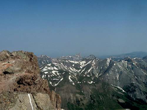
I soon came to the trail registry and signed-in, the trail runs along a creek and after a short while some large boulders appear as the trail gains some altitude and climbs up to where I could see Uncompahgre Peak standing tall in the distance to the west. The trails climbs up out of the trees and gains more altitude on a couple of switchbacks and is obviously well traveled as the trail was rutted a good 2 feet deep into the ground all along this stretch. I could also see hoof prints from horses as this must be a popular spot for riding as well. I then came to a junction and continued west on Nellie Creek trail.
![Uncompahgre Peak]()
The trail then advanced higher over a couple of short rises and then into a vast green clearing where the trail can be seen advancing well ahead. The flowers were spectacular and the colors varied and beautiful; tiny yellow, white blue, purple, red, maroon blossoms on the green slope…………really nice. There were three small snow fields along the way and had to be crossed to stay on the trail. The trail is very well defined the entire way and even I couldn’t get lost as the trail proceeds up into a large, green basin with the trail visible well ahead and up the slope and some long switchbacks advancing up to the saddle of sorts.
I made a good advance and was soon at the saddle and to the left a large, exposed ledge that shown a sheer cliff leading way down to the vast expanse showing Matterhorn and Wetterhorn Peaks and the huge basin below. An awesome sight and here I rested briefly and took in more water as the day was warm but a breeze kept things cooler. I continued on the trail leading across a great expanse and then on to a rocky section where I climbed up a series of switchbacks all the way around the left side of a huge rock bluff that was actually the first portion of the mountain proper.
The trail levels-out through this section and I made my way north all the way around to the west face where I begin the scrambling climb to reach the upper terrain along a loose rocky portion where the trail mostly disappears and then reappears from time-to-time. I then found a gully of sorts and climbed up to where I thought I would gain the summit ridge, the climbing was on fairly good rock and I soon heard voices up ahead and to the left. I emerged and exited at a point where two older gentleman were on the actual trail which I had missed entirely but now found myself in a good position to where the summit ridge was right ahead and the trail clearly defined. I lucked-out.
I climbed the short switchbacks that lead to a large mesa that in turn leads directly across a vast rocky scape featuring a couple on stone buckers that others had built prior for protection from the wind, no doubt. I was soon at the huge summit itself and couldn’t really tell which rock stood the tallest to proclaim itself as the true summit. I walked to the ones that seemed tallest yet found the geological seal and summit register on the next cluster of rocks to the right. Even on the summit I seem to get lost!!..........Anyway on the empty summit at 8:37.
The views were amazing and I signed the register and took several photos one of which is a profound cliff that drops straight down at least 1000’ from the very summit itself to where I couldn’t see well below. Standing on the highest rocks gave an impression of flying almost as the breeze blew and there was nothing around any higher than where I was……….way cool! The two older gentleman soon arrived and we exchanged pleasantries and stories of summit past as it turns-out they each had done all the 14’ers and I found their company to be inspiring and most enjoyable. The views around were somewhat hazy as two separate forest fires were burning about 80 miles away on the Grand Mesa well to the north. Two other guys now arrived as I bid my a dues to the older guys and started on down at 9:07.
![Summit Cliff]()
The trail back down was easier to follow as I kept much better track of the cairns and made it all down back through the rocky sections and to the switchbacks leading back to the saddle. I met several people coming up as the traffic was increasing on this Saturday morning. One larger group was from an outfit called Horizons and had some well-mannered teens and a couple of adults making good progress and another older gal was heading-up solo and I assured her that she’d reach the summit within the hour and a half that she’d predicted. Never alone on a weekend 14’er I was impressed with the nice people I’d met this fine day.
I made good time back down across the flowered slopes and back into the trees well below and along the creek where I dipped my hat in the cold water and placed it on my head for some instant relief from the hot sun. I was down and signed-out the registry and back to my truck at 11:02AM; a most enjoyable hike this fine day with the good weather and all the nice people I’d met. My 40th 14’er…………way sweet!!


Comments
Post a Comment