Final Stats Overview
| - distance traveled on foot: 62 miles
- accumulative elevation gain: 26,300 feet
- distance on motorcycle: 3578 miles
- money spent on gas: $249
- mountain ranges visited: 5
- hotels stayed in: 0
| |
Pre-Trip Preparation
Using SummitPost to become familiar with some of what Colorado has to offer, I began forming the idea of a 14ers trip. I played with the thought of quitting my job, if necessary, to assemble the required amount of free-time. I wanted something that would allow me to combine motorcycling with mountaineering. Having bought a new motorcycle (Suzuki Bandit 1200) recently, this would be my first expedition ride and a good time to become more intimately familiar with my bike. The first major step I took was to ask a couple of experienced Coloradans here on SummitPost which peaks they would recommend for a first-time solo expedition. A handful of the same peaks were suggested by different people.
Several people also offered excellent ideas for the trip which I hadn't thought of. After some research, I made my selection of nine peaks; Castle, Conundrum, Grays, Torreys, Elbert, Uncompahgre, Sneffels, Quandary, and Holy Cross.
From what I gathered, it seemed that the biggest challenge of the trip would be some of the approach roads. With many of them difficult for passenger cars, riding a street motorcycle that is geared for speed and heavy laden with gear, could prove to be a nightmare. Another thing to consider would be the danger of frequent afternoon lightning storms. Every source of information I consulted warned of this as the number one threat on Colorado 14ers. With most of my experience coming from the Cascade Range, I wasn't used to considering this new threat. I would have to aim for early starts and probably camp at most of the trailheads. By mid-summer, the trip was in the final prep stages and it was time to talk to my boss at work. I was prepared for the worst. To my surprise, he accepted my proposal and was even excited about the idea. Knowing that I would have a job to come back to, took a lot of pressure off. The downside of this was that I would be restricted to a two-week time frame and that would not allow much for rest between peaks or unforeseen variables such as weather.
September 1 and 2
September 1st I made my departure and drove roughly 650 miles from Edmonds Washington to Twin Falls Idaho. Besides massacring thousands of bugs (
Photo) with my helmet visor, the drive was uneventful. The second day I drove roughly the same distance again to Durango, Colorado where a friend from my home town was visiting her father.
September 3
On the third day I left early and drove east and then northwest to the small town of Lake City. Cruising over Wolf Creek Pass (10,857 feet), I was hammered by the effects of altitude and reminded that my body had not yet fully acclimatized. The higher I drove, the more light-headed I became. My vision became glassy and I had the strange sensation that I was looking out of someone else's eyes. Quickly realizing I was in trouble, I started pressure breathing and this helped me until I was on the downhill swing. From Lake City I drove to the Nellie Creek road which looked more like a river bed than a passage for vehicles. I knew parking here would add 8 miles to the round-trip length of the first summit but I had no choice. Uncompahgre Peak was my first goal, located in the San Juan Range. With a full pack, I hiked up to camp near the trail-head and spent my first night at altitude. | |
September 4, Uncompahgre
Before sunrise, remembering my experience riding over the pass, I decided to take half a tab of altitude sickness medication, which was left-over from my Kilimanjaro trip. This was not completely necessary but did help with the first few summits of the trip after which I didn't use it again. Leaving in the dark, I walked up alpine grassy slopes to the southeast ridge of
Uncompahgre Peak. Following the upper portion of the route, I watched as predawn light was revealing the finer details of Nellie Creek Basin.
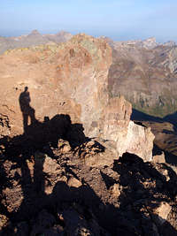
There was a short Class 2 scramble with a few loose pebbles and then I was on my first Colorado summit! The sight of Wetterhorn Peak and Precipice Peak were especially rewarding. People that came up after me congratulated me on my first summit in their state and a few of them looked surprised when they discovered I had ridden a motorcycle to get here.
It was a long, tiring walk back to the bike but I enjoyed the groves of Aspens near the road junction. When my ride was reloaded with gear and strapped down tight, I drove 150 miles through Cimarron and Montrose to get to a peak that was initially only 18 miles away. Once again I found that the quality of the approach road exceeded my motorcycle's capabilities. I parked half way up to Yankee Boy Basin and reloaded my pack, hoping that no one would steal my helmet or other gear. This would add another 6 miles to the round-trip distance of
Mount Sneffels. The road just below the abandoned Sneffels town site is quite an amazing construction. There is an exposed ledge literally cut out of the side of a cliff with one side dropping hundreds of feet down into a river gorge. I reached the lower trail head as it was becoming fully dark and then I made my camp, even though it was illegal to do so. Many people choose to sleep in their cars at trail heads where camping is not allowed. For motorcyclists this is not an option.
September 5, Sneffels
I began my ascent at dawn, excited for what the day had to offer. Judging from my research, the
Lavender Col Route on Sneffels should be the best of the trip. I'm the type who would happily trade an ultra-prominent, highpoint peak for one that has a fun route with better than average views. I respect what high-pointers do, but for me, it's more about the quality of the experience than bragging rights or the satisfaction of completing a list of some sort. That is why I chose to exclude Mount Massive from my selections, even though it is literally across the street from Elbert. In Yankee Boy Basin I followed the road to the upper trail head, at times making faster progress than the 4-wheel drive vehicles that were now creeping into the basin. Crossing talus near the beginning of the trail, a man asked me if I was familiar with the route and expressed some confusion as to which peak was actually Sneffels. I pulled out my beta and showed him a few photos of the route. We ended up as sort of climbing partners for the day and were the first two on the summit.
In the col, I found that staying on the larger more stable rocks left of the center was a lot easier than ascending loose scree.
From the saddle we entered the southeast couloir and followed it near to the end where we found the famed v-notch on our left. The exposure going through the notch was extreme for a non-rock-climber, but knowing that countless thousands had passed through that way before me, I trusted the holds on rocks that appeared to be loose. Above the notch, more easy class 2 led to the summit. The surrounding views of the eroded San Juan Range peaks, especially Gilpin Peak and the Blue Lakes below, were fantastic. I didn't know it at the time, but it was the best view I would see on the trip.
On the way down, my new friend offered to give me a ride from the lower trail head to where my motorcycle was parked. I was quick to accept. In his truck we discussed our experience of the hardships and rewards in mixing international travel with mountaineering. I decided that the drive to the next peak would be too much to cram into the rest of the day. Instead, I road south from Ouray back to see my friend in Durango. The ride from Ouray to Durango might be the most lovely stretch of road I have ever seen and ideal for a motorcycle. Crossing over 11,018 foot Red Mountain Pass, I passed many old, picturesque, abandoned, mining operations.
September 6
240 miles of riding through Pagosa Springs and Buena Vista took me to Leadville and Colorado's highest peak,
Mount Elbert in the Sawatch Range. For once, I found a dirt road that was easy to navigate on two wheels. I made an early camp hidden behind some trees. That evening I spent time reading a book, occasionally glancing up at the northeast ridge with thoughts about the following day.
September 7, Elbert
![Elbert Summit]()
Knowing that the standard route on Elbert was likely to become very crowded, I began at 5 am, using a headlamp for the first hour. A layer of frost covered everything. The first half of the trail was entirely engulfed in trees. About half way up I reached a clearing where there was a refreshing view of alpenglow on Mount Massive. I was truly enjoying myself but the contrast between Mount Sneffels the day before and this route on Elbert was not helping my opinion of Colorado's highest peak. I passed one person on the way up and found the upper half of the route to be more exposed with views down below of the Leadville valley. I was the first on the summit from my route. It was very cold with an added wind chill so I used my down coat for the first time on the trip. There came another person to the summit who was doing the whole Colorado trail at an impressive 483 miles. He was not tagging summits along the way but he said that Elbert would be worth the short detour. I asked him if he had seen many bears in his travels. His reply was that he saw very few at the higher elevations and he even slept with his food in his tent but he warned me not to do that down around established camping areas.
On the descent, as I had anticipated, there were many people coming up. I was surprised by the number of people getting a late start and also those who carried no pack or supplies. After packing up camp, I rode a short distance over to service road 189 which leads up into Stevens Gulch, the standard approach to Grays Peak and Torreys Peak in the Front Range. This road quickly became worse than anything I had driven on yet. I was forced to park again half way up and I reluctantly reloaded my pack. Then, to my great surprise, the hitchhiking trick worked for the first time. This is a technique that I had heard people use whose vehicles can't make it up the forest roads. It didn't work for me on the way down Uncompahgre Peak but this time the very first truck picked me up. The driver told me he was heading up to pick up his dog and wife. Apparently the dog was suffering from a bad case of altitude sickness, appearing wobbly and drunk on its feet, it couldn't walk any further. From the parking lot, I hiked a short way up above the tree line, pitching my tent in the majestic Stevens Gulch. I was walled-in by two 13ers; Kelso Mountain on one side and McClellan Mountain on the other. Shortly after my gear was inside the tent, it was bombarded by large hailstones causing a dull roar that lasted just over 20 minutes.
September 8, Grays and Torreys
I awoke with a start hearing a few people go by on the trail. It was barely dawn. I quickly got ready to go. On the trail I passed the two who had startled me. As I got closer to Grays and Torreys I was impressed by the sight of the basin.
Torreys Peak with its steep east face and snow-filled couloirs certainly looked more impressive than
Grays Peak which appeared as a huge pile of talus. I decided to do Torreys first. A short sprinkle of rain formed a rainbow (pictured at right) over Torreys Peak confirming my decision. I followed the trail west to the saddle and then it was not far to the first summit. I could see the town of Silverthorne from the top. I descended back to the saddle and then, skipping over talus, I made quick work of Grays Peak, all the while watching the clouds thicken and grow in size. I was starting to become familiar with the weather pattern. Each morning the sky would be totally clear and then later in the morning, small clouds would pop up here and there, steadily increasing in size. By noon or thereafter, often a few thunderheads had formed looming over summits and ridges. On the summit of Grays I observed a decent sized thunderhead a few miles away. I thought about the possibility of the wind bringing it over to where I was standing and decided it was time to go down.
![Rainbow Over Torreys]()
When the bike was packed and ready I rode a short distance over to Quandary Peak in the Tenmile Range. No longer taking approach roads for granted, I was pleasantly surprised by the ease with which I drove to the trail head for the east ridge. There were two young men standing next to their car and I could tell by their demeanor that something was out of sorts. I asked them if they were just coming down from the mountain. They told me that they lived in Denver and this was their first attempt of a 14er. They claimed they had almost made it to the summit when they were caught in a lightning storm. One of them said that anywhere he was wearing metal on his body, such as the top of his baseball cap, it became hot and was vibrating. He said bolts were coming down around them and that they ran back down the trail, afraid for their lives. My next question was "What time did you start?". I tried to hide my reaction when they told me 2pm. There were a lot things I could have said at that point but all I said was "You'll want to start a lot earlier than that next time".
At the recommendation of an SPer, I had originally hoped to tackle the
West Ridge Route on Quandary. This route looked like a lot more fun, but I decided against it for two reasons: 1) I would prefer to have a buddy along with me on an exposed route and 2) considering the time constraints that came along with keeping my job back home, it was a better decision to follow the shorter standard routes. Once again I camped behind some trees near the parking lot.
September 9, Quandary
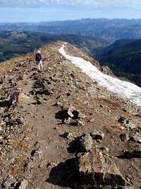
I woke feeling the accumulated weariness from several days of exertion, but my excitement was enough to rouse me into action. On the trail I passed group after group, feeling an egotistical pleasure, until I reached the false summit at just over 13,000 feet. Keeping an even pace and taking snacks while I walk, I have gotten into the habit of not taking breaks. Beyond the false summit I encountered a small family of mountain goats, two adults and a kid. They seemed cautious but unafraid of me and I passed within a few feet of them. Beyond the false summit it became steeper but nothing challenging. On the summit it was windy and there were several people scattered around, stooped to the ground, finding shelter from the wind behind rocks.
The sky had been empty of clouds only moments before but they were building fast. It's a curious process to observe. The view on Quandary was more impressive than some of the other 14ers. I noticed some small lakes to the north and could also make out Grays and Torreys where I had been the day before. On the way down, I encountered a few people who were obviously not in the necessary physical shape to make the summit. Feeling sort of bad about my observation, I told them "good luck". From Quandary I drove through Breckenridge and Minturn to Tigiwon Road. I had heard from multiple sources that this road was a tough drive, "hard on vehicles" and over 8 miles long. For the seventh summit I would attempt
Mount of the Holy Cross in the Sawatch Range. I camped near the base of the road.
September 10
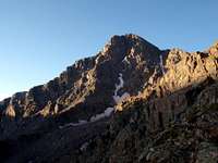
The next day I strengthened my resolve and made slow progress, carefully riding up to the trail head. I hiked over Halfmoon Pass and had my first view of the mountain with its long north ridge and prominent summit block. It was an impressive sight. I descended into the Cross Creek Basin and made my camp next to a small waterfall. This was by far the nicest camp of the trip. Once again, at the recommendation of an SPer, I was extremely tempted to try the
Halo Ridge Route but considering the variables, I settled for the standard.
September 11, Mount of the Holy Cross
With another headlamp start, I made quick progress in gaining the north ridge top. Plentiful
Pikas sounded the alarm as I passed by, telling each other that a predator was invading their domain. Here I met an older man named Carl and we hiked together scrambling up the boulders toward the summit, watching as the sunrise painted colors on Mount Jackson. Carl explained to me that every year he makes a point of climbing one 14er and one 13er but that 2009 was a good year because it was his second 14er. On the summit, several more people appeared and together we discussed the difficulties of climbing Mount Rainer. Thinking about the ride to Aspen, I bid Carl farewell and hurried on back to my motorcycle.
Going to the Elks Range, the drive over 12,095-foot Independence Pass was especially rewarding. Here I recognized all the views of mountaineering without any real effort on my part. On the far side of the town of Aspen, I followed Castle Creek Road to the end of the pavement.
My instructions for
Castle Peak and
Conundrum Peak told me that the gravel beyond was in good shape for the first mile. I quickly found that this was not the case.
After a half mile, the road was so bad that I decided to turn around and park it. Shortly after this decision, I lost control of the bike. I was walking it down the road with my feet out on either side, carefully tending the brakes. With all the loose rocks of varying sizes, my top-heavy motorcycle literally flipped on its side and dropped between my feet. I cursed in frustration, damning all the Colorado back roads. I unloaded some of the weight and tried to right it but was not able to do so. Walking down the road I found some hunters and they were able to help me get it back up. After that I called it a day. In my tent I sat thinking, trying to form a plan. How was I going to tackle these last two peaks now that I was unable to drive the road? The thought of 15 miles and nearly another 5000 feet of gain was staggering in my exhausted state. I would either have to get lucky hitchhiking, or get an unholy early start.
September 12
Constant thundershowers kept me confined to the tent all day. That night the weather would not remit and I had a feeling that I was seeing the end of my luck.
September 13
At 4 am the next morning I considered the early start idea. The rain was still a constant and not conducive to the idea of getting out of my sleeping bag. It seemed like conditions out of my control were making up my mind for me. I went back to sleep for a couple hours. Spending twenty-four hours alone in the tent had left me anxious for some kind of action. The second time I opened my eyes the answer was very clear. It was time to go home. I couldn't handle another day of waiting in the tent to see what the weather was going to do.
The trip which started as a small daydream from browsing pages on SummitPost had grown into a major success. Seven Colorado 14ers in eight days. How many others could claim such an achievement? So what if I didn't get the last two peaks. Nine peaks in nine days would have been sweet, and anyhow I knew that I was physically capable. That small frustration would serve as a motivator to plan future trips to Colorado. As I rode out of the basin back toward Aspen, I looked over my shoulder at the peaks up above. Twenty-four hours of rain on my tent had been twenty-four hours of snow in the upper regions. There was no way to tell just how much snow had fallen up there. Nature had slammed the door on me, but I was ok with that.


Comments
Post a Comment