Muztagh Ata, China Post-Trip Reflections
Three months after climbing and skiing from the summit of Muztagh Ata, I feel like the trip has finally set in. What sticks out most in my mind are a few key themes:
How wild and untamed this region of the planet is
The incredible generosity of the local people, despite their poverty
The value of persevering through difficulty and uncertainty
Why?
The purpose of this trip report is to give useful information to others interested in climbing or skiing Muztagh Ata. When planning for the trip, I found a dearth of useful information (what is the best gear to bring, how cold does it actually get, do you need crevasse rescue gear, what stove can you find gas for in China, etc). I hope that this trip report will better prepare people to climb and ski a big peak in China.
Video From Our Expedition
Pre-trip Planning
When I travel and plan for expeditions, I do it with a learner’s mindset. I am always looking to understand local culture, customs, and history. For me, a simple test of a trip's success is whether or not you were invited into a stranger's house for a meal. It was with this mindset that I started planning for a ski mountaineering expedition to Xinjiang, China.
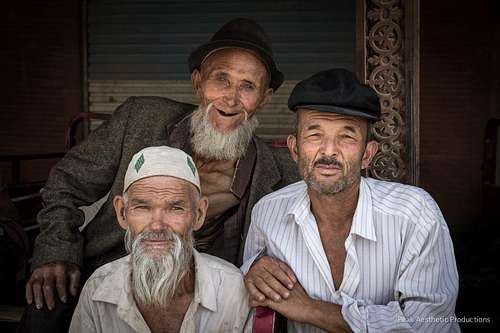
![Uygher Men near Market, Kashgar, China]()
I took this shot in a market a couple of hours outside of Kashgar, in the Xinjiang autonomous region of China. Xinjiang is populated largely by the Uygher people, a historically nomadic group of Muslims. The Uyghers are some of the most hospitable people amongst whom I have ever traveled. Throughout our trip they showed a genuine interest in our well-being and a strong desire to share their culture with us. I felt truly blessed to be one of the few foreigners traveling throughout Xinjiang; in the four weeks that the three of us spent there, we did not meet another person from the Western Hemisphere. I consistently find it a shame that Westerners have such a biased and largely negative perspective of Muslim people. I hope that my photos and trip report will encourage others to get out and see parts of the world that we know mostly through our media outlets.
My climbing partner, Aron Ralston, and I wanted to summit Muztagh Ata without porters, cooks, or a guide so we set off to look for companies willing to offer us a bare-bones package. After extensive searching we narrowed it down to 2 companies who could offer us a climbing package on our timeline (Aron only had 17 days to be in Xinjiang):
1) Kashgar Mountaineering Adventures (KMA) http://www.ksalpine.com/
2) Tour Asia Travel Agency http://www.travel-central-asia.chttp://www.travel-central-asia.com
While I researched mountaineering companies, I was also learning about the history of Xinjiang. The people in Xinjiang are mostly Uyghurs, an ethnic minority oppressed by the dominant Han Chinese (think of Tibet). While Xinjiang is an autonomous region of China (again, think of Tibet), Chinese politics completely dominate the region. In fact, the Chinese government has more legislative oversight in autonomous regions than other provinces in China paradoxically making them less free. The whole system is very “Chinese”, and the more that I researched, the more I understood that I wanted to climb with a company that solely worked with local people (Uyghur, Kyrgyz, and Kazak ethnic minorities). Kashgar Mountaineering Adventures (KMA) is the only company to employ all Uyghur people, and in the spirit of supporting local businesspeople, it made the decision of booking with KMA rather easy. In short, we were completely blown away by the professionalism, service, and true friendship that came from working with KMA. The company consistently went above and beyond to ensure that we were well-fed, having fun, and being safe. I would recommend using their services in a heartbeat!
![Mustagh Ata Food]() Picking out food in a Kashgar market.
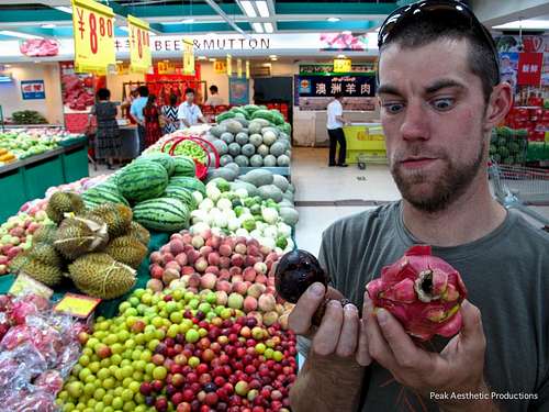
After landing in Kashgar, Aron and I wanted to quickly pick up some fruit, nuts, and cheese for the climb. What our driver brought us to blew our mind: a mega-Walmart-style-underground-shopping-district that extended, literally, for several city blocks. After wandering aimlessly around the "supermarket" we found everything we wanted except for cheese. Although we lacked the communication skills necessary to ask where the cheese was, we were able to successfully mime out milking a cow, passing the milk through a cheesecloth, and waiting while the magic of time turned rotten milk into delicious cheese. Still, nothing; no one could help us find cheese. We eventually pulled up a photo of a cheese block on Aron's phone. Still, no cheese. After driving around, walking through labyrinthine stores, and searching for cheese for 3 hours, we eventually turned to our sullen driver only to have him say (in English): "THE CHINESE DO NOT EAT CHEESE". We all busted up laughing at the incident, which left us wondering why he hadn't mentioned this during our 3 hour search. Oh well, it's China after all.
Picking out food in a Kashgar market.
After landing in Kashgar, Aron and I wanted to quickly pick up some fruit, nuts, and cheese for the climb. What our driver brought us to blew our mind: a mega-Walmart-style-underground-shopping-district that extended, literally, for several city blocks. After wandering aimlessly around the "supermarket" we found everything we wanted except for cheese. Although we lacked the communication skills necessary to ask where the cheese was, we were able to successfully mime out milking a cow, passing the milk through a cheesecloth, and waiting while the magic of time turned rotten milk into delicious cheese. Still, nothing; no one could help us find cheese. We eventually pulled up a photo of a cheese block on Aron's phone. Still, no cheese. After driving around, walking through labyrinthine stores, and searching for cheese for 3 hours, we eventually turned to our sullen driver only to have him say (in English): "THE CHINESE DO NOT EAT CHEESE". We all busted up laughing at the incident, which left us wondering why he hadn't mentioned this during our 3 hour search. Oh well, it's China after all.
Climbing Muztagh Ata “Independently”
In order to climb Muztagh Ata, you need a 7,000 meter peak permit, a liaison officer, and a basecamp manager. For those interested in cheaper trips, it is worth mentioning that we didn’t meet anyone on the mountain who paid less than $2,380 per person for the package. We also heard rumours of Chinese climbers paying upwards of $7,000-$8,000 per person for fully guided trips. The typical adage of “you get what you pay for” may apply to some of the companies operating on the mountain, but we paid less than anyone we talked to, and I can certainly say that our basecamp had some of the best food, hands-down the best vibe, and the friendliest staff around.
Along with the necessary documents, booking with KMA provided us with:
● All necessary overland transfers from Kashgar to the mountain, and back to Kashgar (including airport pickup)
● Enough camels for gear portage from Subashi to BC and BC back to Subashi
● Three nights hotel accommodations in Kashgar
● 10 total days of food at Basecamp (BC) during the expedition
● A cook at BC, his salary, and his insurance
● Liaison officer, required by the government at BC
● One day sightseeing in Kashgar
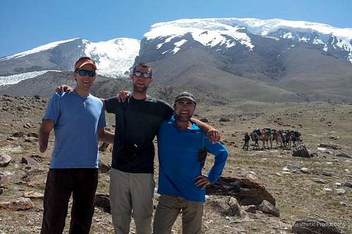
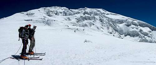
![Mustagh Ata]() Aron Ralston, myself, and Michael Ash at the base of Muztagh Ata.
Aron and I met Michael at basecamp, and he quickly became an indispensable member of our expedition. He had come to Muztagh Ata to try and be the first person to kite-ski above 20,000'. Unfortunately, the wind never fully cooperated with him and he had to be content kiting in the Kashgar plaza under the watchful gaze of a Chairman Mao statue.
Aron Ralston, myself, and Michael Ash at the base of Muztagh Ata.
Aron and I met Michael at basecamp, and he quickly became an indispensable member of our expedition. He had come to Muztagh Ata to try and be the first person to kite-ski above 20,000'. Unfortunately, the wind never fully cooperated with him and he had to be content kiting in the Kashgar plaza under the watchful gaze of a Chairman Mao statue.
Camp Information
All of the different companies operating on Muztagh Ata share one large area for a basecamp. Thanks to the rapid spread of consumerism in post-Mao China, there is a China Mobile tower at basecamp. Other cell providers do not work on the mountain. With the assistance of our local driver, we were able to purchase a SIM card in Kashgar for our smartphone (although this process was not efficient) and were able to call to the United States, even from our high camp at 21,000’! How’s that for service? We were also occasionally able to upload small photos to Instagram so that our sponsors could track our progress while we were climbing. It is definitely worth making sure that your phone works for calls and data (this took us several separate visits to China Mobile) before leaving Kashgar.
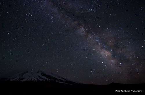
![Mustagh Ata and Milky Way]()
The Milky Way is about the only thing that dwarfs Muztagh Ata. This photo was taken from Subashi, where we spent our first night. From Subashi, we hiked in to basecamp the following morning.
Timelapse of the western vista taken from basecamp, looking into Tajikistan.
Camp Name and Information
Subashi: Small village of yurts past Lake Karakol. Accessibly by any vehicle (just off the highway). 3,750 meters = 12,350’
Basecamp: End of the path accessible by scooters from Subashi 4,400m = 14,500'
C1: Near the line where the snow meets the rocks in summer. 5,200-5,400m = 17,500'-17,800' (with a pre-C1 site at 17,000')
C2: Flat bowl on the glacier. Relatively protected from the wind. 6,200m = 2 sites at 19,900' and 21,000'
C3: Relatively flat area. 6,800m = 22,500'
The camp descriptions and elevations posted above are for the typical camps that groups set on the mountain. We chose to make our own camps away from the larger, organized tour groups. Aron, Michael, and I were one of a couple teams climbing the mountain without the support of cooks, porters, or a guide. Because of this, we decided to eliminate a Camp 3, and chose to make our second camp at a higher elevation (21,000'). If we had a few more days available in our schedule we would have benefitted from coming back down to basecamp after acclimating for several days at Camp 2 to regain our energy before making a summit push.
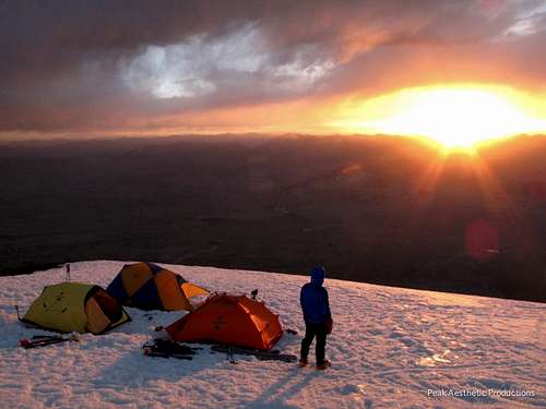
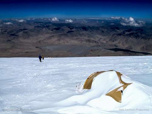
![Mustagh Ata Camp I]()
Aron took this shot while at Camp 1. We felt fortunate to spend 5 nights in this glacial-clad heaven. The views of the surrounding mountains were spectacular, and we acclimated well to the elevation. We could also ski/jog back to basecamp in ~1.5 hours in case we wanted a big, home-cooked meal.
Climbing Schedule
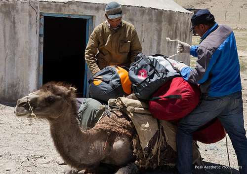
![Mustagh Ata and Camels]() I consistently found it odd that we were using camels to get our gear to basecamp.
I consistently found it odd that we were using camels to get our gear to basecamp.
Day 1 Arrive in Kashgar. Transfer to Subashi, sleep at Subashi
Day 2 Hike, acclimating, and sleeping at BC
Day 3 Rest day at BC, sleep at BC
Day 4-5 Carry to C1, sleep at BC (5 nights at 14,400')
Day 6 Move to C1, sleep at C1
Days 7-9 Rest at C1, sleep at C1
Days 10-12 Carry to C2, sleep at C1(6 nights at 17,800’)
Day 13 Move to C2, sleep at C2
Day 14-15 Rest day at C2, sleep at C2
Day 16 Summit day, sleep at C2 (4 nights at 21,000’)
Day 17 Return to BC, sleep BC
Day 18 Drive to Kashgar, sleep in a hotel thank God
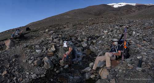
![Skiing Mustagh Ata, China]()
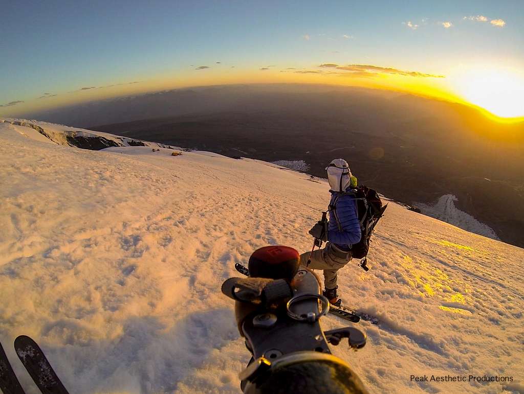
Michael took this incredible shot of Aron (down below, on the glacier) and me skiing down from C2 to C1. The only semi-technical sections on the peak are visible in the bottom of the photo: two short climbs out of glacial bowls/depressions. The more serious climb was about 30' and had a fixed line with knots in it (photo below). Depending on the time of day, we found the climb to be mushy snow that was easy to kick steps into or hardpack/glacial ice that was difficult to climb without crampons. Neither of these obstacles would be worth remembering or mentioning on a peak like Rainier, but the elevation made the obstacles more strenuous.
Climbing and Skiing
![]()
Our team decided to bring full crevasse rescue gear to China. On our first carry to Camp 2 (see photo below) we roped up, as we were unsure of the glacial conditions higher on the mountain. Given the facts that we were hauling all of our gear, and that none of the Chinese teams were roping up, we decided we did not need to haul pickets, harnesses, or rope higher on the mountain. That said, we had heard two reports of people punching through the snow into small crevasses during the climbing season. My advice would be to bring full crevasse rescue gear to the peak, and then make your decision to use it based on recent on-mountain reports of snow/ice conditions.
![Mustagh Ata Climbing]()
On the skin up to set our Camp 2, we were feeling confident and discussed strategies for setting camps higher on the mountain. We decided to continue past the typical Camp 2 at 20,000' with the idea of eliminating the need for a Camp 3. That day ended up being by far the most exhausting as we climbed from 17,800 - 21,000' with moderately heavy packs. We continued another 800' past the typical Camp 2, and decided to set our own Camp 2 while our unacclimated bodies -- tired after 8 hours of skinning -- were barely able to hack a platform for our tent. In the process our shovel broke, leaving us doggie-paddling to dig out the snow and make a suitable camp. Michael also developed a hacking cough which he would not be able to kick for the rest of the expedition. It was hard to see someone so strong -- the first person to tele-ski down Denali -- reduced by such a condition. We finished cutting the platform at 7:00 PM, with around an hour and 1/2 left of daylight to ski back down to the thick, luscious air of 17,800'.
![Mustagh Ata climbing ice step]()
Fortunately, the ski down to Camp 1 was one of the most glorious ski tours I have ever completed. On the descent, the view of entire glacier opened up beneath us, revealing thousands of feet of snow lit up by the alpenglow of the setting sun. You could see well in Tajikistan, the interior of China, and south towards Pakistan. It was a glorious moment, made that much more vivid by the day's struggle. By the time we got back to Camp 1, we were hooting and hollering with such enthusiasm that the Austrian team camped next to us came out from their tents to congratulate us on what they imagined to be our successful summit bid. Needless to say, they were fairly disappointed when they found out we had only set up our second camp.
Here is a bit of ski footage from the mountain with some clips of the alpenglow towards the end of the video.
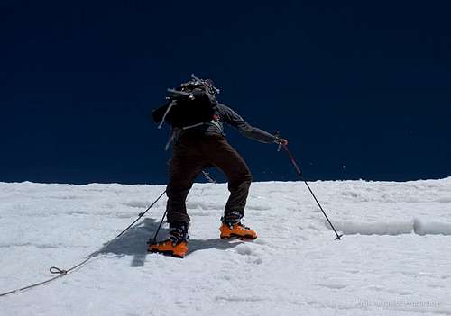
I was constantly impressed by Aron's resolve to climb the fixed line -- a 70 degree climb up a 30' knotted rope with one hand. At 18,500'. With all of our carries, we passed this section 6 times.
I was also constantly impressed by the resolve of the Chinese -- smoking at 21,000'. In a whiteout. Granted none of the Chinese climbers were carrying more than 10 pounds. And most of them had oxygen. But still, smoking cigarettes at 21,000'.
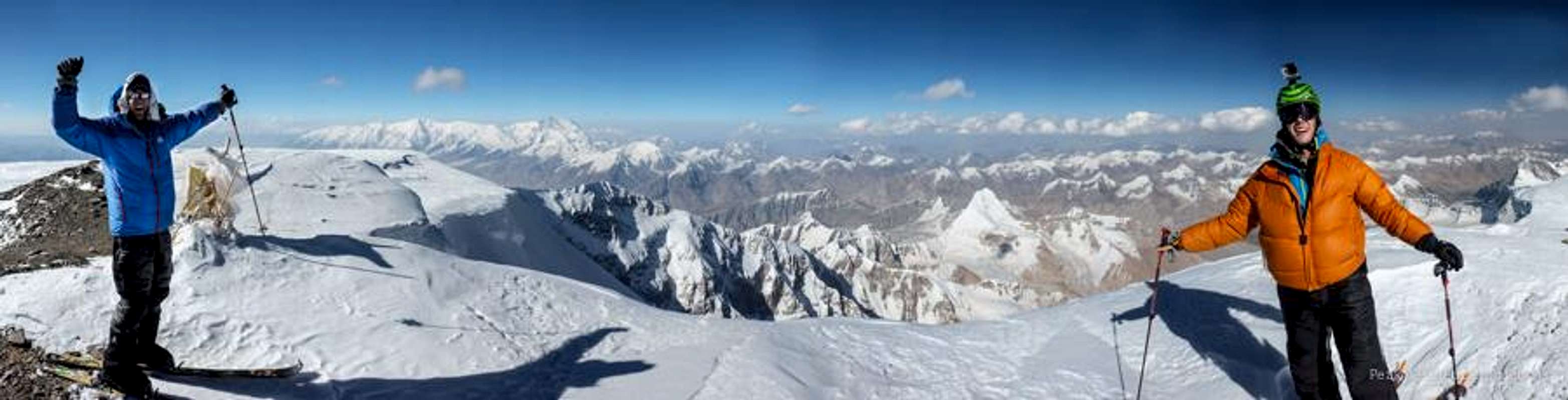
![Mustagh Ata Camp II]()
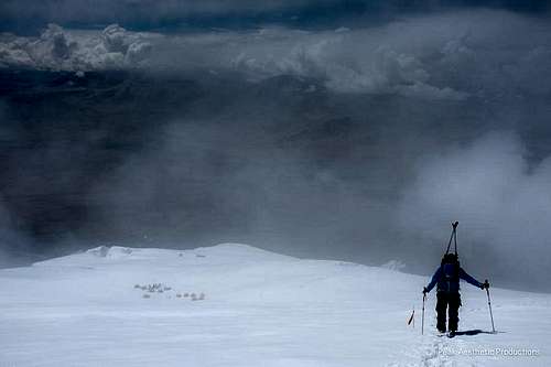
The view from Camp 2 extended south towards K2 and Broad Peak. At points we felt like we were imagining the final ridge of distant mountains visible in the distance. The peaks were so plentiful and the views so ever-changing that I bemoaned having the tent zipper closed. I found myself putting the expansive views into the context of the geopolitical history of the region. Just weeks earlier, 10 climbers were killed at the basecamp of Nanga Parbat, around 200 miles to the south. I couldn't stop thinking about the compassion and genuine sincerity of our Uyghur basecamp manager Muhammad. On the night before our summit bid, we called down to basecamp and spoke with Muhammad. He told us to be safe, that he was worried about us, and that he would pray for us. After we hung up, I pondered the disconnect between the Western media's biases of Muslim people and Muhammed's prayers to Allah for safety of a couple of Americans.
![Mustagh Ata Camp III]()
On that same night we also called home to family members. It had been an interesting 14 days. Each of the three of us had run the full gamut of emotions. For at least a day, we each had our strength reduced to that of a toddler, due to raging coughs, intestinal illnesses, and over-exertion. But when we called home, our emotions swayed to the other end of the spectrum. I had an incredible call with my Dad, and when I hung up I burst into tears. Aron spoke to his father, and followed suit. Michael called his son and, not wanting to be the odd one out, let a few tears fly.
The following morning we were making progress towards the summit, skinning by first light. We stopped at the Chinese Camp 3 to brew up a batch of tea, catch some well-needed rest, and drop weight. We had only been climbing at a rate of 300' an hour. It was a brutal slog. Michael's progress had been slowed considerably by his worsening cough.
On our 14th day on the mountain, Aron and I summited Muztagh Ata in bluebird conditions. We felt truly lucky to have the expedition be successful. On the other hand, we were saddened that Michael didn't end up making the summit due to his cough. Aron and I still talk about how we could not have climbed the peak without him.
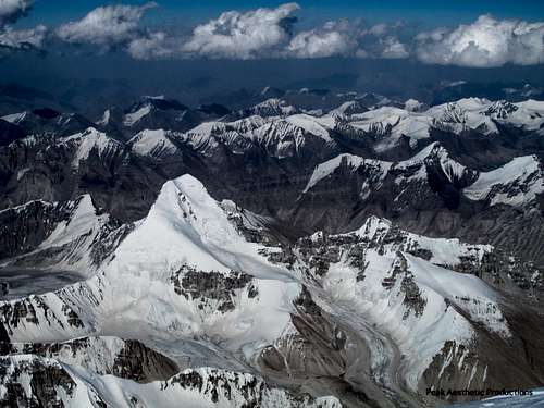
The views east of Muztagh Ata were wild. Unnamned, unclimbed 5,000' - 6,500 meter peaks shot up from the glacier like weeds. The main, prominent peak in the foreground is called Tuyuk Peak, and sits at 6,161 meters. This image is a high resolution photo and should be opened up for full viewing pleasure.
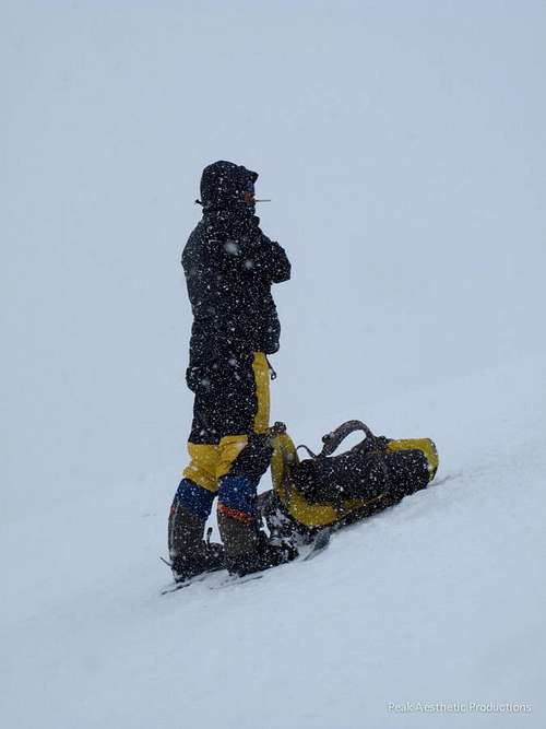
The carry off the mountain was brutal. Everything that was brought up in 3 carrys was brought down in 1. Michael snapped this photo of Aron and I taking a well-deserved drink break. Our basecamp manager Muhammad came up to meet us and bring us back camp.
Mountaineering Reports in the Range
Here is an informative American Alpine Journal PDF on the Kulun Shan range.
I am currently looking for other reports of climbing in the area. If you know of any, please post them on the comments section.
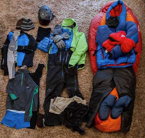
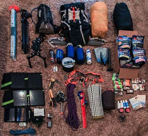
Gear
I found it difficult to locate an accurate gear list for Muztagh Ata, so I will post some notes about the gear I found most useful on the mountain as well as a full gear list.
- We used 40 Degree Overboots modified to fit our Dynafit bindings while skiing. The guys at 40 Degrees were very helpful, and while you may not end up needing the overboots on the climb, we brought them along as a piece of safety gear. We found them most useful around camp, as a second layer over down booties.
- Aron and I both had -20 degree down sleeping bags. I used the Marmot Col MemBrian bag, which I loved.
- We found our most useful clothing to be lightweight merino wool layers, by IceBreaker. After 16 days in one shirt, we were blown away that they did not smell and were still comfortable to wear.
- We brought a complete solar kit from GoalZero to China. We carried one Nomad13 panel to Camp 2, and were glad to have it to recharge our iPod, speakers, and camera batteries. We also brought a Sherpa 50 power pack to Camp 1, which allowed us to store solar energy and then recharge our devices when it was overcast. I highly recommend these products for the intrepid traveler looking to get off the grid.
- For two years in a row, Aron and I have used Kiehl's products, especially their High Altitude sunscreen.
- While our food at basecamp was wonderful, we came supplied with 17 days of dehydrated meals from MountainHouse. Their ProPaks have the extra air taken out of them, which makes them better for high altitude trips. We found ProBars to be the best snack between meals.
- I preloaded GPS points into a Garmin GPS, and (as one would expect) found the unit's altitude readings to be far more accurate than our altimeters. Despite thorough searching, I do not believe that good basemaps exist for the Muztagh Ata area.
- Although we shot professional footage while in China, Aron and I both brought along GoPro Hero helmet cameras. The units are cheap and lightweight enough that it is worth it to bring one, even if you plan on also shooting on a DSLR. I also loved being able to shoot video hands-free at higher altitudes and found the quality to be great, especially for POV shots.
- Aron and I made 100 bamboo wands with bright duct tape before heading to China. These are incredibly useful for early season trips, although the bigger organizations thoroughly wand the trail up to Camp 3. Their success rate is very low above Camp 3, so I would plan on having sufficient wands for the mountain above Camp 3.
- White gas (as one would use in a Primus or MSR pump stove) was not available in Kashgar at the time of our trip. Apparently the Chinese are worried that the Uyghers are going to make weapons from it. This forced us to use JetBoil stoves, which we continuously had problems with. Aside from keeping the cartridges warm (the compressed gas does not function well in the cold), it was difficult to keep all of the stove parts warm enough to function.
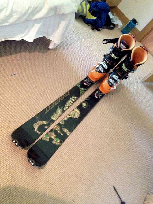
- I skied on Dynafit Mustagh Atas (I know, fitting) and Scarpa Maestrale boots. Check out Lou Dawson's Wild Snow for the most up-to-date reviews on ski mountaineering gear. Suffice it to say that if you plan on skiing, you want the lightest setup that you can afford. I recommend sacrificing boot-warmth for weight, and bulking up with a pair of 40 Degree Overboots.
Here is my complete gear list, along with photos.
Final Thoughts
"May your trails be crooked, winding, lonesome, dangerous, leading to the most amazing view. May your mountains rise into and above the clouds." Edward Abbey


Comments
Post a Comment