
|
|
Mountain/Rock |
|---|---|
|
|
40.77750°N / 107.2495°W |
|
|
10577 ft / 3224 m |
|
|
Overview-Colorado's Forgotten Mountain Range
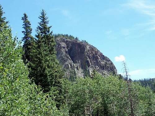
Bears Ears is perhaps the second most recognizable and famous mountain in northwest Colorado, after the Rabbit Ears. There are two peaks forming the Bears Ears; the northwest peak or ear is 10,577 feet elevation, and the southeast ear is 10,497 feet elevation. From the west, the northwest “ear” looks like a mini-Devils Tower since both peaks have columnar jointing on the vertical faces. The summit register (good condition in 2005, but deteriorated as of 2009) indicates 5-8 signatures per year, almost certainly making this the third most popular mountain in the Elkhead Mountains.
Several aspects of the Elkheads make this a rather unique mountain range in Colorado. It is certainly possible that the Elkhead Mountains are the least known of the major mountain ranges in Colorado. This is partially because the range is a long way from any metropolitan area, and partially because the Elkheads are fairly low by Colorado standards, as there are no peaks reaching 11,000 feet. There are also few lakes, so the range isn’t visited by fishermen. Despite their low altitude, the Elkheads receive much snow, and snow lasts into July on the higher peaks. Most of the peaks in the Elkheads see very few ascents, but Hahns Peak, the eastern-most peak in the range is a popular climb for residents of Steamboat Springs. The Bears Ears see quite a few ascents by Elkhead standards, because of their prominent shape and visibility from the Yampa River Valley. Black Mountain is also climbed fairly often because it is the highest point in Moffat County, and the popularity is on the increase with more county highpointing interest. The rest of the peaks see few ascents, and one ranger has told me some of the peaks only have a few names in the registers since 1980. So, there are few hikers around, but hunting is another story. The Elkheads are very popular for hunting in the fall and contain large populations of deer, elk, bear, etc.
One thing unique about the range is that hiker use is overall actually decreasing, rather than increasing as it is in most places in Colorado. The summit registers (which the Forest Service keeps record of) on most peaks indicate that they have had more ascents in the 1960’s and 1970’s than they do now. Even before that, there were many summit logs from the 1930’s and 1940’s from sheepherders.
The Elkhead Mountains are made of old volcanic rocks 17-25 million years old. One thing unusual is that the Elkhead Mountains run west to east as opposed to north and south as most of the ranges run in North America. It is impossible to describe the general forms of the peaks because they are all so different, but most of the peaks are isolated rises from a huge plateau which forms the bulk of the Elkheads. The Bears Ears themselves are steep-sided dome shaped mountains with high vertical cliffs on some sides. The west and south faces of the west ear are vertical as is the south face of the east ear. According to the forest service, the southwest face of the west ear has only seen one ascent, back in 1969 (see below). The rock does not lend itself to good technical climbing and is very crumbly. The west peak of Bears Ears is a fairly short, but very steep climb.
Elkhead Mountains-10,000+ Foot Peaks with 300+ feet of Prominence
 Bears Ears form TR 1145.
Navigational Warning
Warning:
None of the maps available show the roads (and there are no trails) on Bears Ears accurately. The closest one that bears resemblance to reality is the Forest Service Map-Routt National Forest, but even that one has a note on the access road that reads “approximate location only". The USGS maps do not show the last road to the trailhead at all. The USGS maps don’t show some of the other roads in the area as well, but seem to show roads and trails that don’t exist; at least not any more.
Update:
The USGS has (finally) updated the 7.5 minute maps. They were scheduled to be produced for Colorado last year, but I’m not sure when they will hit all the stores. Right now you can get/see/print/buy the new 7.5 minute maps on My Topo.
The good news is that all the roads and trails are FINALLY accurate for the Elkhead Mountains (and undoubtedly other areas as well). After receiving the new maps, I am very pleased to see that the roads and trails are in the right places. I am also very pleased that the USGS has a new agreement with the US Forest Service and within the national forest service areas, the private land holdings are shaded (but only in USFS areas, land ownership is not shown outside FS lands) on the 7.5 minute scale maps.
Getting There
Northern Trailhead
From the junction of Highway 40 and 13 in Craig, turn north on Highway 13. Drive north for about 13 miles to north of mile marker 102 until you see a sign posted for County Road 27. The road is posted for “Forest Service Access” and “Black Mountain”. Drive County Road 27 through private lands for 10 miles which is where you reach the Routt National Forest boundary. The road becomes FR 110. From the Forest Boundary, follow FR 110 for 9.7 miles to FR 116. Turn right on FR 116 and drive 2.5 miles to FR 1161. Turn right and follow FR 1161 and take two lefts on FR 1161C. Park at a logged over area where Bears Ears-NW Peak is clearly visible to the south. The road is rough in places, but should be passable to a car if you drive slowly.
If you take the right fork at the last junction you will reach a turn around which might make an alternate trailhead west of the Bears Ears.
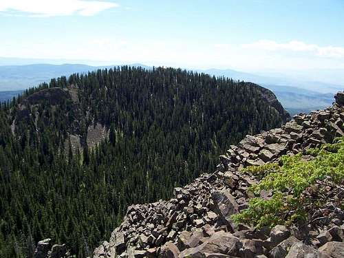
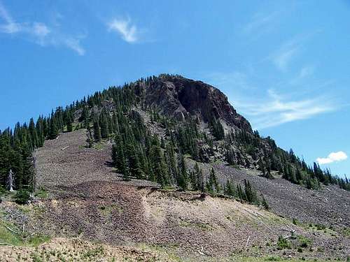 The Northwest Ear and highest summit from the west.
North Fork Elkhead Trailhead (Southern Route)
Directions to the trailhead will be brief because you had better have a Routt National Forest map in hand. Don’t try finding the trail without it.
My route from Craig, followed Highway 40 east to County Road 29 (CR29), turned north past Elkhead Reservoir, right on CR 18, left on CR 76 to a major junction (there are several minor junctions before this, and at one unmarked one, I took a short detour left at a ranch).
A sign will say the main road right is private. Turn left on the 4wd road and drive it to the trailhead. The road is rutted and rough in places, and stay off it when it is wet. It should open in mid-June in most years, but sometimes later. 4wd is definitely required for the last few miles, but you can walk it if you have a car. The trailhead is at an old stock pond dam and a trail sign.
If coming from Hayden, you can head directly north on CR 76 and stay on it all the way to the junction with the private road mentioned above. This will be the least complicated route for most people.
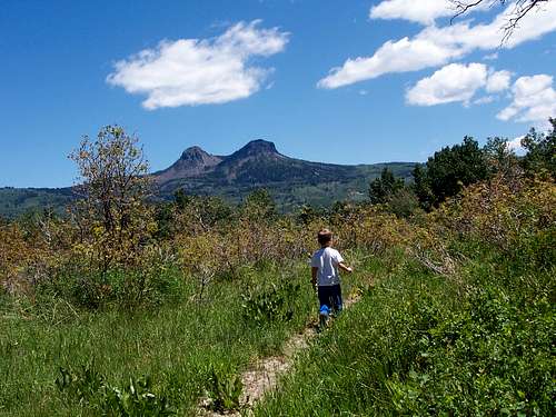
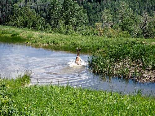 Elk near the trailhead.
Routes Overview
There seem to be several routes available to the peak, but I have climbed only one at this time. The Northwest Ear from the North route is short, but extremely steep. There is a trail-of-sorts for part of the way, but this is the steepest “trail” I’ve seen in Colorado, so be prepared for some rather loose footing. This is probably the shortest route to the highest point, and it may or may not be the easiest.
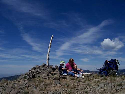 Mighty conquerors of the Bears Ears. It is quite the scramble to reach the summit pictured here.
For a longer access route to the same (or other) routes, see the North Fork Elkhead Route which will make a fine backpack though some pretty wild country. This route will take 2-3 days for most people.
I went through the summit register, dating back eight years and it appears that some people have climbed Bears Ears from the road far to the south. There is an old abandoned gravel pit west of the NW Ear and it appears that you could traverse over to the North Route as described on the route page. The west face is vertical.
It also appears that the NW Ear can be climbed via its east side or northeast side, but there would be some route-finding and scrambling around some possible cliffs.
 The southeast, and lower "Ear"as viewed from the highest summit (Northwest Ear).
The southwest face of the NW Ear was climbed on August 6 1969, by Mike Heid, and reportedly never repeated. It looks pretty loose and dangerous, and doesn’t look worthwhile to me.
The Southeast Ear appears that it could be climbed from the north ridge, northwest face, or northeast face. If you climb the Southeast Ear before I get there, please post a route page.
According to Les Anderson, the Southeast Ear is harder to climb than the Northwest Ear because of thick timber.
There are no guidebooks currently in print (the book Colorado's Elkhead Mountains: A Mountain Climbing Guide and Historical Reference is a good one for the history of the area, but is hard to find), nor is there any printed Forest Service information on these peaks, so unless you climb the route with the route page, expect to find a route on your own. Although Bears Ears isn’t very popular by Colorado standards, the Forest Service keeps an archive of all summit logs going back many years, all the way back to the 30’s and 40’s. This is the most complete summit log archive of any mountain in NW Colorado. If you are interested in finding info on other routes, you could stop in the Bears Ears District Ranger Station and look through the archives.
SP member Rheagan writes:
I climbed both ears by approaching the lower ear from the south. I saw the ears from the Yampa River and drove to the Elkhead Range as described in the text. I used a topographic map, but had no knowledge of any trail. On Forest Road 116, I began hiking almost directly north and bumped into a Peruvian sheepherder who directled me to an alpine meadow intersecting a steep scree slope on the south side of the lower ear. I cut short switchbacks across the VERY steep scree slope up to the saddle between the ears. After a rest, I "bagged" the lower ear by walking the ridgeline.
I then crossed the lowest portion of the saddle and skirted around to the northern side of the higher ear. The hike up from there is easy, less steep, and with no false summit like the lower ear. The summit register indicated no other climbers for more than a month. However, while I was on the summit, a hunter (in full-on camo Carhartts, sneakers, and no shirt) came sprinting up to the marker. He stopped his watch at 22 minutes from the nearby road to the north and said he had just won a bet with his friends below. I think he was shocked to see a woman up top! I followed him back down and walked along the road for the 5-or-so miles back to where I had left my truck.
Red Tape
No permits are required.
When To Climb
July through early September could be considered the normal season to climb the mountain. The access road usually doesn’t open until July, and it would be a really long walk in the winter. The road to the southern trailhead may be open in mid-June.
The Elkheads are a very popular hunting destination in September and October (until snow closes the road), so use extreme caution at this time of year. In winter or spring, this would be a very long trip, and there are no winter ascent summit logs in the archives, indicating that the mountain may possibly still await a first winter ascent(??).
 The highest summit of the Bears Ears from the Northwest in July.
Camping
There are many informal campsites along the road to the trailhead after you reach the forest boundary. The Sawmill Campground is quite a ways west of the trailhead and now cost $10. It is the only official campground in the area.
Mountain Conditions
CLICK HERE FOR THE BEARS EARS WEATHER FORECAST
Below is the National Weather Service Climate Summary of Dixon/Baggs, on the Wyoming/Colorado border. The data is from 1922-2005. This is the closest long term weather station, but be aware that higher elevations will be much wetter and colder. Dixon/Baggs is at 6370 feet elevation, so expect the temperatures on Bears Ears to be 10-20 degrees colder than in Dixon/Baggs.
| MONTH | AVE HIGH | AVE LOW | REC HIGH | REC LOW | AVE PREC (in) |
| JAN | 32 | 3 | 55 | -55 | 0.89 |
| FEB | 36 | 8 | 61 | -47 | 0.72 |
| MAR | 43 | 16 | 75 | -31 | 0.96 |
| APR | 56 | 27 | 84 | -9 | 1.14 |
| MAY | 67 | 34 | 93 | 9 | 1.18 |
| JUN | 76 | 41 | 96 | 20 | 0.94 |
| JUL | 83 | 47 | 99 | 30 | 1.07 |
| AUG | 81 | 45 | 100 | 26 | 1.12 |
| SEP | 72 | 36 | 92 | 1 | 1.04 |
| OCT | 61 | 27 | 82 | -9 | 1.23 |
| NOV | 44 | 16 | 77 | -26 | 0.80 |
| DEC | 35 | 3 | 62 | -39 | 1.02 |
Jeremy Hakes - Jul 1, 2010 9:25 am - Voted 10/10
Joe Kramarsic's booksAll of his books are available directly from the author/self-publisher: Joe Kramarsic PO Box 1342 Dillon, CO 80435 Book: $18.95 Tax: $1.09 Mailing:$2.58 Total: $22.62 He includes a shipping discount for buying several books at once, which is nice.