
|
|
Route |
|---|---|
|
|
40.65700°N / 111.77°W |
|
|
Technical Rock Climb |
|
|
Half a day |
|
|
III 5.5 |
|
|
III |
|
|
Approach
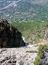
From Wasatch Blvd., turn east onto Oakview Dr. (4275 South). This road is immediatly north of a pedestrian overpass that crosses Wasatch Blvd. Follow Oakview Dr. uphill and make a right turn on Jupiter Dr. (3735 East). Follow Jupiter Drive south and and turn left on Adonis Drive (4505 South). Drive a short distance to Thousand Oaks Drive (4500 South) and turn right. Continue up Thousand Oaks Drive, continuing past a sharp left turn, to a cul-de-sac above two water tanks, and park.
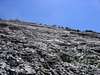
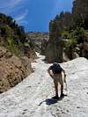
Fom the parking, start up the dirt trail towards the approach gully following some switchbacks. At the bottom edge of the gully, the trail will eventually dissappear and become a 2nd class approach through the lower part of the gully which will have some third class sections.
 |
 |
 |
 |
 |
Route Description
This route, although easy, is really fun. The lower pitches "make" this route, but the upper pitches have their share of interesting sections as well.
The route can probably be climbed anywhere on the wall and still remain 5.5, but it is best to just start at the lowest part on the wall and weave your way up following the path of least resistance.
A prominant land mark on this route is a giant ledge roughly 350 ft high up the wall with a 2 bolt anchor. This should be easily recognized to to the fact it is the largest ledge, and had the only bolts we encountered on the climb.
Length = 900 feet (give or take)
Descent:
This is the descent listed in "Rockclimbing Utah's Wasatch Range" by the Ruckmans.
"The west ridge of the North Face is the best descent route. A few moves of exposed scrambling are involved near the top of the ridge. After reaching the shoulder below the West Ridge, either descend down the gully to the west of the ascent gully, or scramble east following the base of the slabs, to reach the start of the climb. from here, continue back down the ascent gully.
It is also possible to continue along the ridge from the top of the climb to the north summit, and descend via the Kamp's ridge descent. A considerable amount of scrambling is involved this way, not to mention an additional trek through the neighborhood to get back to your car. "
My friend and I descended down the gully to the west of the approach, but that had horrible bushwacking and a nice trip through the city to try and locate are car. Best of luck on finding a descent down!
References:
"Rock climbing Utah's Wasatch Range" by Stuart and Bret Ruckman
"Wasatch Quartzite" (out of print) by John Gottman
History tidbit provided by mtn runr regarding the West slabs and John Gottman: The out-of-print book WASATCH QUARTZITE that you site was written by John Gottman and published by the Wasatch Mountain Club in 1979. John Gottman was killed in a climbing accident (cornice collapse) in New Zealand (I think) many years ago. There is supposed to be a memorial plaque commemorating his life somewhere on the West Slabs.
 |
 |
 |
 |
 |
Essential Gear
Protection on this route can be pretty marginal. Fortunately, the climbing is easy. Make sure you take advantage of every possible spot for protection, because there are many places on the route that can have 50 foot runouts. But the harder sections are well protected.
 |
Miscellaneous Info
If you have information about this route that doesn't pertain to any of the other sections, please add it here.
PellucidWombat - Jun 6, 2005 11:39 am - Hasn't voted
Route CommentI found nuts and hexes to be pretty useless on this climb. Having a lot of cams of various sizes can be helpful for setting marginal pro in flaring cracks or making anchor belays in the wide cracks along the dihedrals and roofs.
PellucidWombat - Jun 6, 2005 11:41 am - Hasn't voted
Route CommentThere is now a set of railroad tie stairs leading from the road up to the climbers trail.
The climbers trail drops down and follows a fence for a short ways before merging with the abandoned dirt road.
For early season ascents, an ice axe is recommened as the snow in the approach gulley is very hardpacked and can last most of the summer.
PellucidWombat - Jun 6, 2005 11:48 am - Hasn't voted
Route CommentIf you head directly up the smooth face just to the right of the chute that heads up from the slab's lowest point, you can reach a tree with slings (5.4, ca. 160 ft).
From here, if you head to the dihedral to the right, it offers more place for pro and has a level spot for a gear anchor. (5.5)
Above this is the large ledge with a huge tree that makes a nice belay ledge (5.5 left of the dihedral, 3rd class on top of the dihedral). I never saw the aforementioned bolts here.
Beyond this is a large open face that likely requires a little simul-climbing (5.4 to easy 4th). If you can reach the roof above, there is a tree growing out of it that has some rap slings and makes a good anchor.
Heading up and left w/ a little simul-climbing (cl. 4) is another good belay ledge w/ a good tree anchor.
Beyond this we pretty much simul-climbed & free soloed the slab.
PellucidWombat - Jun 6, 2005 2:49 pm - Hasn't voted
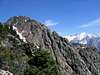
Route CommentFrom the top of the west slab, scramble east up the ridge (fun cl. 3-4) until you meet up with the West Ridge route. From here you can either descend the ridge, descend the North Face Trail or climb to the north summit, from where you can traverse to the south summit and descend the main trail.
stewart13 - Jun 17, 2013 8:36 pm - Hasn't voted
Beehive at base of West SlabsI came across a huge beehive today at the base of the West Slabs Route (right where the hiking stops and the climbing begins). Luckily I had come up the left side of the snow and the beehive was on the right (west side) of the base of the rock. Be careful, I've never seen or heard such a giant beehive before, yikes!
Trelle - Sep 18, 2018 9:56 am - Hasn't voted
Different trailheadPreviously you used to have to skirt though a neighborhood. As of last year theres a trailhead for the Bonneville shore line trail. Go up this a little ways and the trails will split. Head east or left. http://www.utahoutside.com/2013/11/hiking-the-new-thousand-oaks-section-of-the-bonneville-shoreline-trail/
agentkirkwood - May 18, 2020 10:55 am - Hasn't voted
Free Soloing the West SlabsMid May, 2020: Free solo'd this route with a group of 6, 1 whom was experienced with the approach to SL Valley's crown jewel. I want to comment about our great experience simply because I was not able to find much information online regarding free solo-ing The West Slabs without belays or rappels. One should seriously consider whether taking on this risk is appropriate for them self. There were moments that my group termed "spicy" during which, despite the easy climbing moves, a mistake would likely be fatal. Be mindful of the risks. If you have plenty of experience climbing harder routes roped up, the West Slabs will feel okay. If this makes you uncomfortable find someone to guide you up with ropes or simply find another of the Wasatch's infinite possible adventures. Also, wear a helmet! The rock was mobile up there. And, simple shoe chains worked well on the snow in the approach gully, in lieu of full crampons.