
|
|
Mountain/Rock |
|---|---|
|
|
44.62000°N / 9.20000°E |
|
|
Hiking |
|
|
Spring, Summer, Fall, Winter |
|
|
5387 ft / 1642 m |
|
|
Overview
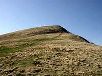
Monte Carmo is a summit of the Ligurian Apennine and the top ( 1642 mt ) is near the Piedmontese – Ligurian and Emilia Romagna boundary.This beautiful mountain has a trapezoidal form, summit plane but enough isolated from other mountains.
Half mount is covered with trees and the second part near the top are covered only with grass.
Carmo and Antola are important and many people, simple walkers and serious excursionists want reach the top.
 |  |
Getting There
THE SOUTH RIDGETo reach by car the starting point for Carmo, exit at Vignole – Arquata toolgate and follow the road sign to Vignole Borbera, Borghetto Borbera, Cantalupo Ligure, Albera Ligure, Cabella Ligure, Carrega Ligure, Capanne di Carrega at 1367 mt and stop here the car near near the only AGRITURISMO ( little bar and inn ) on the street before the signal of Genova province.
If you come from Genova, is possible to find a normal route, to go out the Busalla toolgate and follow the road sign to Casella, Montoggio, Laccio, Torriglia, Propata, Casa del Romano, Capanne di Carrega The path start 50 meters after a boundary signal of Alessandria province near the only AGRITURISMO ( little bar and inn ) on the street.
Both the ways you are at the starting point to normal route sign with a two yellow rhombs.
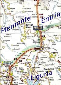 Great map of Carmo
Itinerary
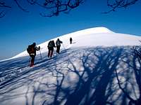
THE SOUTH RIDGECAPANNE DI CARREGA 1367 m - TOP OF CARMO 1642 m DIFFERENCE IN HEIGHT 275 m
This is a normal route to climb Carmo. A brief easily path for all trekkers. Always good remarkable path, large on the first part inside the wood; on second part simple because the summit is clearly visible. The slight slope assure a good walk. Near the top is possible find a brief by-pass on the left to avoid the steep slope in front of us.
Attention at snow in a winter and in a spring seasons. The high altitude and the distance from the sea in this part of Apennino not permit at snow to dissolve on all parts of path.
 |
Refuge
Basecamp to climbing Carmo is refuge Casa Del Romano. 1 Star.
Address Località Casa del Romano, 62 - 16020 Fascia (GE) - Liguria
Tel (+39) 010/95946
Top
The top of Carmo is place at 1642 mt and a big black cross ( 3 meters in height ) sign it.The panoramic vision here is beautiful. The sea of Genova and the plane ( pianura Padana ) are always visible. If there is visibility is possible to see Mount Bianco, Cervino and Rosa.
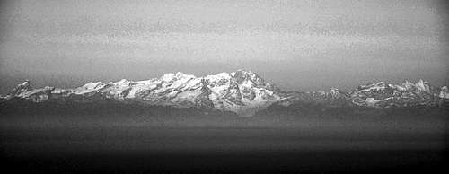 In sunny day even, is possible to see Monterosa.
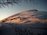
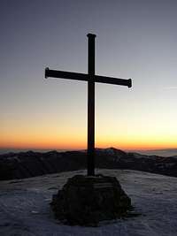 Cross of Carmo in Winter
Natural Park
Carmo zone are in the great natural park of Antola. Many selvatic animals live here: Foxs, deers and wild-boars.Meteo
From IL METEO.ITFascia ( GE )
Carrega Ligure ( AL )
White as the Alps!
Carmo in a magic shot in winter."...What does a man want in this icy desert?"
 |  |  |  |
Thank you Cedad for this first two shot!