
|
|
Mountain/Rock |
|---|---|
|
|
44.58138°N / 9.11166°E |
|
|
Hiking |
|
|
Spring, Summer, Fall, Winter |
|
|
4600 ft / 1402 m |
|
|
Overview
Mount Buio is a mountain ( 1402 mt ) between the regional boundary Liguria Piemonte. Buio is placed on idealistic prosecution of summit like Carmo 1642 mt and Antola 1597 mt; all this mountains are on the watershed ligurian – padanian. Buio and Alps
Getting There
NORTH WEST RIDGETo reach with a car the starting point to climb Buio, i recommend exit at “ISOLA DEL CANTONE” toolgate ( Motor-way A7 – Genova – Milano ). The road to run along after we exit from motor-way, isn’t the main ( neither to Genova nor to Arquata, Novi or Milano ) but a minor road with some curve but in plain. Now, the torrent Vobbia is on the right, under the road for 13 km. There aren’t crossroad as far as Vobbia village. Here must follow the road signal to Vigogna, Poggio, Vallenzona ( here start the path to climb Buio ) or to S.Clemente’s pass.
If someone has information about other roads, can write me an e mail. Thank you.
 Great map of Buio
Itinerary
THE NORTH WEST RIDGE ( Signal path a Yellow square )VALLENZONA ( 685 mt ) – TOP OF BUIO ( 1402 mt ) DIFFERENCE IN HEIGHT 717 mt.
The path start near the Vallenzona’s church. The way is always excellently marked. There’s a little torrent but is easily to cross it. After, the path enter in a wood ( slight slope ). Turn right at crossroad. Now we are in a large and plane path and after a long way, we can see all Vobbia’s valley.
Our approach at Buio ( from this ridge always not visible ), we reach Sesenelle’s pass ( 1256 mt ), at the boundary with Piemonte. Another crossroad here arrive from S.Clemente’s pass ( 1129 mt ).
Now the steep slope for the last attack to Buio ( 10 minutes ) is always inside the wood on the boundary between the two regions. Only on the last 50 meters the trees disappear. The panoramic vision is amazing. We are at 1400 meters and a great black cross sign the summit.
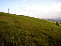 Summit of Buio
If someone has information about other ridges, can write me an e mail. Thank you.
Top
The top is without trees and we can see Antola link with Buio with an aerial ridge long 3 km typical of high mountain and so far away ( 23 km ) the Ligurian sea.The black cross is high 4 meters, and its pattern is beautiful. It’s keep fit. It stay over a cement support high 2 meters.
The cross is placed on 1968.
 Cross of Buio
Natural Park
Buio zone are in the great natural park of Antola. Many selvatic animals live here: Foxs, deers and wild-boars.Meteo
EUROMETEO : Airport of GenovaVIRGILIO METEO
GENOVA 24 km far-away
ALESSANDRIA 54 km far-away
PIACENZA 69 km far-away
Flora
This's the magic moment! A reflex between the leafs... |  | 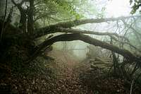 |