

-
 96120 Hits
-
 89% Score
-
 28 Votes
|
|
Area/Range |
|---|---|
|
|
34.72350°N / 98.7451°W |
|
|
Hiking, Sport Climbing, Toprope, Bouldering, Scrambling |
|
|
Spring, Summer, Fall, Winter |
|
|
Overview
Charon's Garden Wilderness (Charon being the ferryman of Hades in Greek mythology, and properly pronounced "Karen") is a rugged landscape of wind sculpted granite summits and canyons, odd rock formations, and great climbing and hiking. Its 5,723 acres are a part of the Wichita Mountains Wildlife Refuge reserved for day hiking and limited backcountry camping. It is the location of several good climbing summits (for Oklahoma!), including Elk Mountain, Mount Lincoln, Granite Mountain, Twin Rocks Mountain, Crab Eyes and Sunset Peak (among others). These offer a variety of climbing activities, from class 1 to 5.11c. But, much of the climbing is across the granite rock slabs and boulders that make up a large part of the wilderness.Charon's Garden mountains are estimated to be 300 million years old. The very coarse granite in Charon's Garden has been determined to be 500 to 550 million years old. Boulder slides in the drainage depressions are common on many of the steep slopes.
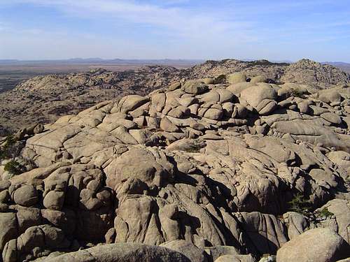
Looking west from the center of Charon's Garden Wilderness.
Although the adjacent photo makes the area appear quite rocky and almost devoid of fauna, that is not entirely correct. Adjacent to Charon's Garden Wilderness are the grass-covered plains that make this region suitable for bison and elk. Because the ground is rocky, the area has remained "protected" from the farmer's plow, allowing native grasses to thrive. Within Charon's Garden are pockets of post oak tree thickets. And the low-lying locations offer grassy, marsh-like areas along a number of small, seasonal streams. These areas become a virtual riot of color when the wildflowers bloom in the spring. There are also several small lakes adjacent to Charon's Garden, and even two small waterfalls along the streams that feed them.
Charon's Garden Wilderness Map
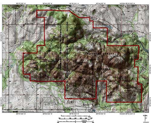 Map showing the wilderness area
History
 A loan bison grazes beneath Elk Mountain.
The human occupation of the Wichita Mountains region begins in prehistory. It was a favored hiding place of both the Comanche and Kiowa Indians. The Spanish are known to have traded with the Indians here, and legends of Spanish gold hidden amongst the rocks of the mountains still persist. French traders passed through the area in the 1770’s. It is from them the name Wichita, as well as the Ouachita Mountains to the east, is derived. It is a French corruption of a Native American word. The first American to enter the range was Colonel Henry Dodge, who dickered with Indians in the Wichitas in 1834, while trying to halt raiding on the Santa Fe Trail. In 1843 Texas Republic President Sam Houston authorized negotiations to take place between the Texans and the Comanches. The Texan delegations found the Comanches in the Wichitas and it was there that the treaty was drafted and signed. The Marcy surveying expedition explored the Wichita Mountains during the same expedition that took them to the Caprock Canyonlands.
The Wichita Range was eventually brought under the jurisdiction of the Fort Sill Agency, located just south of the mountains. Fort Sill was the reservation to which the Comanche, Kiowa and some of the Apache were relocated. The Kiowa chief, Lone Wolf, the Comanche Quanah Parker, and even Geronimo, were residents of the Fort Sill Reservation.
Mining took place in the Wichitas, although it petered out at the beginning of the 20th century. The Doris campground began its life as a mining camp. In 1901 the refuge was split off of Fort Sill Agency and established as the Wichita Forest Reserve. In 1905 President Theodore Roosevelt altered its status to a Game Preserve when he visited the Wichitas. It was then added to the fledgling National Wildlife Refuge system, which had been established in 1903. Bison were introduced in 1907 and elk were transferred from the Elk Refuge in Jackson, Wyoming shortly thereafter.
The 8,750-acre Wichita Mountains Wilderness was established in 1970. A subset of the Wichita Mountains Wilderness, the Charon’s Garden Wilderness contains 5,700 acres. The remainder of the wilderness is found in the North Mountain Unit, which is found in a part of the refuge that does not have public access.
Getting There
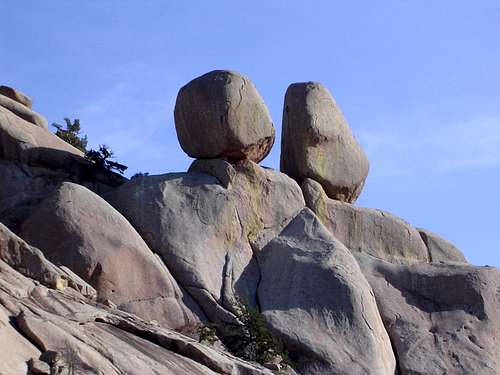 The Apple and Pear are bigger than they look!
The Sunset trailhead is where most trips into Charon's Garden begin. To get there:
From I-44 take Highway 49 (exit 45). Go west 10 miles to the Refuge gate. Proceed through the park, past the visitor center, and turn right at the stop sign. Continue west and turn left into the Sunset Picnic Area.
If coming from Highway 62, take Highway 115 (Cache exit) north to the Refuge Gate. Proceed north. The road will turn west and continue until turning left into the Sunset Picnic Area.
There is also a trailhead at the southern end of the wilderness between Post Oak and Treasure Lakes. To get there, turn off the main park road at the park headquarters and proceed south. The road will veer right and continue west for a ways until it dead ends at the trailhead.
The following map may prove useful:
o Map to the Wichita Mountains Wildlife Refuge
Red Tape
General. The Charon's Garden Wilderness area is located in the Wichita Mountains Wildlife Refuge. Unlike most wilderness areas, this one is administered by the U.S. Fish and Wildlife Service (USFWS). No permits or fees are required to climb or day hike, but backcountry camping is by permit only.Backcountry Use. Rules for backcountry camping are: No more than ten persons per time period (total in the backcountry), no more than three days, two nights stay (beginning at sunup of the first day and ending at sundown of the last day). Stays are limited to Friday through Sunday, and Monday through Wednesday. Camping is not permitted on Thursday nights. Campsites are restricted to a specific area within Charon's Garden Wilderness. Backcountry permits may be obtained up to three months in advance. To obtain one, contact the USFWS at:
U.S. Fish and Wildlife Service
Wichita Mountains Wildlife Refuge
R.R. #1, Box 448
Indiahoma, OK 73552
(580) 429-3222
If you call, they will make a tentative reservation for you (or let you know if a time period is booked). They will then mail you a reservation form. You have ten days to mail the form back, along with $2.00/backcountry camper. You will receive a permit, thus confirming your reservation. The reservation fee is non-refundable, should your plans change. Walk-in reservations, if available, may be obtained at the Refuge Headquarters. Note that walk-in reservations are rarely available during the spring, fall or school breaks.

Technical climbing in Charon's Garden.
LNT/Climbing Ethics. Wilderness rules and ethics apply. In addition, open fires are prohibited. With the exception of Charon's Garden Trail from Sunset to Treasure Lake/Post Oak Lake, and Elk Mountain Trail to the top of the mountain, there are limited trails in Charon's Garden: Know and practice LNT hiking ethics. Bury human waste at least 200-feet from water sources, but carry out toilet paper. Specific LNT climbing practices for the Wichita Mountains Wildlife Refuge include:
o Use established trails to reach climbing areas.
o Treat the rock gently. Do not chip, chisel, glue or otherwise deface it.
o Bolting is not permitted without prior approval.
o Minimize chalk use and brush off heavily chalked holds
o Use natural color webbing if you must leave fixed slings.
More information about Rock Climbing in the Wichita Mountains Wildlife Refuge is available from the USFWS here:
o Rock Climbing--Wichita Mountains Wildlife Refuge
Alcohol. Alcohol, including beer, is not permitted in the Wichita Mountains Wildlife Refuge.
Dogs. Dogs are permitted, but must be restrained on a leash.
Speed Limits. The speed limit (45 daytime in most areas, 35 nighttime, with some areas marked slower) are strictly enforced.
Swimming. Swimming is not allowed in any waters in Charon's Garden Wilderness.
Camping
Backcountry. Camping in Charon's Garden is by permit only. See "Red Tape" for procedures to obtain a permit. Permits are issued for a maximum of ten people in the backcountry at one time. Backcountry camping area.
o Charon's Garden Backcountry Camping Information
Front Country. Doris campground is a few miles away and is a good option if you do not want to sleep in the backcountry. It has 47 non-electrical tent/RV campsites ($8/night), 23 electrical tent/RV campsites($16/night), and 20 primitive (walk-in) tent campsites ($6/night). Water, restrooms and showers are available. Non-campers may shower at Doris Campground for a fee of $2. Advance reservations are not accepted for Doris campground. Hours (when the gates are open) vary by season. Check the following link for the most current info:
Pothole ecosystems in Charon's Garden.
Doris Campground also has three group sites, two with electricity and pavilion, one without. Rates vary from $24-36. Advance reservations (three months) are taken for the group sites. The following link has more info:
o Doris Campground Group Site Information
Another great option is the Fawn Creek group campground on the eastern border of the wilderness. At $5/stay for a group (8-30 people), it can be cheaper than Doris campground, and you can head up into the wilderness directly from there if you don't mind some bushwhacking. It is, however, reserved for youth groups through the university level. Fawn Creek has four primitive campsites that each have several picnic tables and large charcoal grills. There are restrooms across from campsite C. For reservations in Fawn Creek, contact the park headquarters at (580) 429-3222, 8:00 a.m.-4:30 p.m., Monday through Friday. For more info on Fawn Creek, check the following link:
o Fawn Creek Campground Information
Trails
There are two designated trails within Charon's Garden--All other hiking is bushwhacking. The two trails are: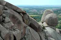
Window Rock, and Apple and Pear by Cdoiron
.Elk Mountain. A 1.1-mile (one-way), 590-foot elevation gain, class 1 trail to the top of Elk Mountain. Beyond that, bushwhacking and scrambling can take one to the Elk Mountain summit block, Apple and Pear and a great view of Valley of Boulders. Expect to see occasional visitors along this trail, though the further one goes west on the summit the fewer they will number.
Charon's Garden Wilderness Trail. A 2.4 mile (one-way), 150-foot elevation gain, mostly class 1 trail between Sunset (on the north) and Treasure Lake/Post Oak Lake (on the south).
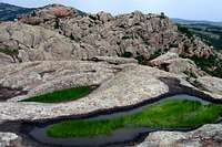
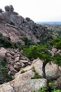 Valley of Boulders.
You will likely find other "trails" that take off in one direction or another, before disappearing altogether. These are often fun to explore, and can lead to some interesting finds (such as a second mine, not the documented Bonanza Mine, located at 34° 42.817N, 98° 43.94W).
 Post Oak Falls
If you stop by the visitor center, you can obtain a nice, large, color topo map of the Wichita Mountains Wildlife Refuge for a few dollars. This map, printed on plastic, has been prepared by the Public Lands Cooperative Association in conjunction with the USFWS. It does not, however, have the backcountry camping area marked. For that, you will need the map that the USFWS provides you with your permit (see the topo map linked immediately below). In lieu of the map purchased from the visitor center, you can download and print this non-topo trail map of the entire refuge (only Elk Mountain and Charon's Garden Trails are within the boundaries of Charon's Garden):
o Hiking Trails of the Wichita Mountains Map
You may also find that this quad topo map of Charon's Garden is useful (second page of the link):
o USGS Quanah Mountain Quadrangle Topographic Map
The USGS quadrangle that includes Charon's Garden. This very large file has been made available under the Creative Commons License.
Summits
There are a number of summits in Charon's Garden. Beta for most is available on the appropriate SP mountain pages. The summits, as described in the respective SP mountain pages, include:Elk Mountain. Elk Mountain is a 2270-foot jewel in the chain of granite domes which make up the Wichita Mountains of Oklahoma.
Elk Mountain.
Mount Lincoln. Mt. Lincoln rises 2201 feet in the southeastern part of the Charon's Garden Wilderness. It is the closest, major peak to the south trailhead, just south of the more popular Elk Mountain. There are no trails to the summit and the climb is very rocky and rugged. In the cooler months, the climb is well worth the effort for its stunning views of the south walls of Elk Mountain, a substantial portion of the Charon's Garden Wilderness, and east into the eastern Wichita Mountains. Wildlife including elk and buffalo are likely to be in the area.
Twin Rocks Mountain. Twin Rocks is the most central peak in Charon's Garden, and offers some great 360 degree views from its 2192-foot summit. This granite peak offers typical 3rd and 4th class scrambling and, because of its difficult access, you will likely be alone on its summit.
Sunset Peak. Solitude is the attraction for this 2180-foot peak in the Wichita Mountains of Oklahoma. Within the relatively small area of the Charon's Gardens Wilderness, Sunset Peak is a gem of a day hike. Solitude is the result of the lack of trails in the area, thus, a climb of Sunset Peak is almost a total bushwhack. That is one of Sunset Peak's appeals, and you will enjoy meandering your way across the scrub oak prairie and granite domes of the wilderness.
Granite Mountain. Granite Mountain rises 2177 feet above the remote and very rugged western side of the wilderness, making it a great wilderness climb with very little chance of seeing anyone on or near the summit. As with other locations within the Charon's Garden Wilderness, Granite offers plenty of bouldering and probably contains some walls high enough for some traditional rock climbing. There are no trails to the summit.
Charon's Garden Mountain. Isolated in the far western reaches of the wilderness, Charon's Garden Mountain reaches approximately 1,905 feet upward.
 The Crab Eyes.
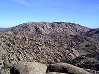
Mt. Mitchell Massif (unofficial name), at 2145 feet, is a collection of unnamed peaks in the more remote section of Charon's Garden Wilderness. Of the six 2000 foot+ summits that are in the wilderness, Mt. Mitchell Massif is the the only one that is officially unnamed. There are five major points on the massif itself, along with two more nearby peaks (see Pt. 1928 and Pt. 1860 section on the Mt. Mitchell Massif page). It is possible to make a nice class 3/class 4 loop (with class 5 possible) of these peaks (see route page).
Crab Eyes. The Crab Eyes are a unique rock formation in the northern part of the Charon's Garden. The name comes from two large boulders delicately balanced on a thin column of granite. The views from the 1920-foot summit of Crab Eyes are spectacular, with Elk Mountain, Mt. Lincoln, Granite Mountain, Twin Rocks Mountain, Charon's Garden Mountain and Sunset Mountain all visible.
Bat Cave Mountain and Phantom Mountain. At 1855 feet and 1962 feet, respectively, these two summits are located about 1/3-mile apart in the far southeastern corner of the wilderness. Although adjacent to Indiahoma Road, this part of the wilderness is only lightly traveled--you may very well be by yourself if you attempt either of these summits.
Bat Cave Peak. Bat Cave Peak, formerly referred to as unnamed 2070, (not to be confused with the officially named Bat Cave Mountain described above) is generally located at the end of the higher ridge extending south from Mt Lincoln. It is one of the most eye-catching formations in the refuge, especially if you are viewing it from east to west. It appears as a thumb or knob protruding toward the south. It is climbable without the use of ropes, etc.
Water
 Little Falls.
Though Caddo Lake, Treasure Lake and Post Oak Lake are along the northern and southern edges of the wilderness, most water sources within the boundaries of the wilderness consist of seasonal streams. Many of these streams will surface magically, then disappear a few hundred feet away. Sometimes you may find animal feces floating in a water source, so you might prefer to carry a water filter (vice boiling or using tablets). After heavy rainfall, there are pothole ecosystems that remain filled with water for a few weeks, allowing both plant and animal life to thrive in unexpected places. Because of the fragile, transitory nature of these water sites, it is best to not take any water from them except in an emergency. Before entering the wilderness for an overnight stay, you might wish to visit with the USFWS rangers at the visitor center and learn the current water situation.
External Links
o USFWS Wichita Mountains Wildlife Refuge WebsiteOfficial website of the U.S. Fish and Wildlife Service.
o Charon's Garden Backcountry Camping Information
Information, regulations and a map for backcountry campers in Charon's Garden.
o Hiking Trails of the Wichita Mountains Map
A simple trail map, non-topo, of the entire Wichita Mountains Wildlife Refuge.
o USGS Quanah Mountain Quadrangle Topographic Map
The USGS quadrangle that includes Charon's Garden. This very large file has been made available under the Creative Commons License.
o Wichita Mountains Climbers Coalition
Dedicated to protecting the climbing resources and natural environment of the Wichita Mountains.
o The Meers Store and Restaurant
Website for this popular Oklahoma landmark. Be sure to eat one of their famous hamburgers!
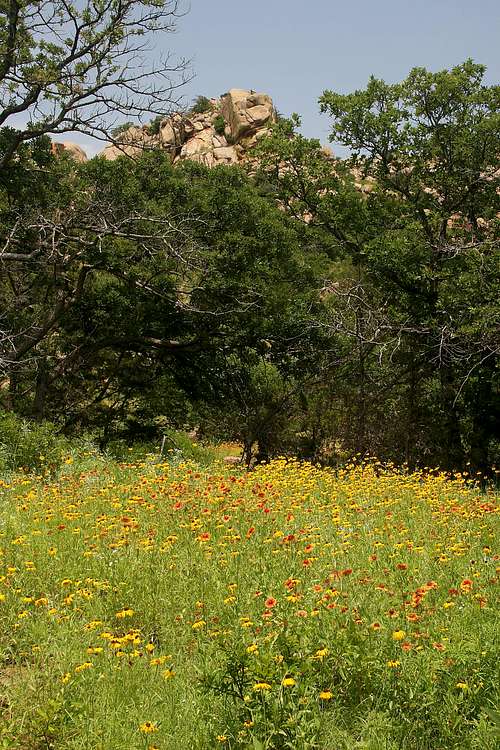 Wichita wildflowers.