
-
 8874 Hits
-
 78.27% Score
-
 9 Votes
|
|
Mountain/Rock |
|---|---|
|
|
34.71227°N / 82.27112°E |
|
|
Mountaineering |
|
|
19780 ft / 6029 m |
|
|
Overview
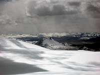 Bad weather
A very desolate peak which is hard to reach.
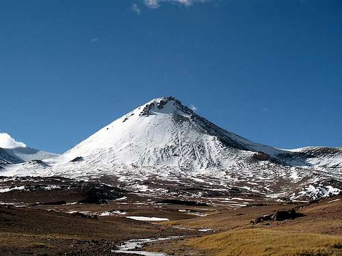
The Toze Kangri Range is 25km long (N-S) and the summits are flat snowy peaks. All but one. Toze Pyramid on the south end on the west side. It's a pointed mountain which stands out from the rest. The highest point is just over 6000m. It's not a difficult climb except for the last 20m. The rocky summit is dangerous because the rock is very rotten. Steep almost vertical exposed climb. Maybe UIAA 5. The rest is first a walk and then up to 50 degrees on snow and ice. There are many ways to climb to the summit rock. Some routes on rock ridges all the way and other on not steep scree ridges.
You can see many light blue lakes and impressive mountains from the summit.
Getting There
 From NW
Go to China, then to the extreme west to the city of Kashi in the Xinjiang province. You can go here by airplane from Beijing, change aircraft in Urumqi. Also by train from Beijing or any other city in China.
From Kashi, go by bus or private transport to the border pass of Xinjiang and Xizang provinces. Head east on small dirt tracks for 220km. Sometimes difficult to find the right way. Pass north of lake Puer. Then you see the Toze Kangri peaks.
Red Tape
 Rock peak close to T Pyramid
Visa for China. Available at Chinese embassies all around the world. Price depends on nationality.
Climbing permit. You can get this through China Mountaineering association.
Camping
Camping is possible everywhere. Strong winds. No risk of theft.Summit views
 Looking NNE Looking NNE |
 Looking E Looking E |
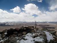 Looking NW Looking NW |
|---|
Weather - climbing period
The Toze Kangri Range is located in the north of the Tibetan high plateau. The weather here changes fast. Winter is too cold. Spring can limit access due to mud and full rivers. The summer is full of rain, snow and hard winds. This is Kunlun's "monsoon". Fall is best. Stable weather, good temperature and good access.On the mountain
 West ridge
Base camp is best set on the WNW side. Here you have access to water most of the year I think. On this side there are some deep valleys which give shelter from the hard wind. There are also interesting rock walls you can train on. You can also camp N of the peak. Less water and less shelter and a more hard rock ridge with rotten bastions.
Maps
Maybe the best is the Russian maps. 18 000 of them can be found here for free downloading or cheap price.External Links
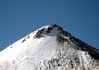 Close up of top part
There is nothing of interest on the web. The peaks are unknown to most.
Mentioned here
PDF map here. Not about Toze Kangri or Toze Pyramid. Only general for the area.