
-
 15430 Hits
-
 84.27% Score
-
 18 Votes
|
|
Mountain/Rock |
|---|---|
|
|
32.23470°N / 111.1588°W |
|
|
Pima |
|
|
Hiking |
|
|
Spring, Fall, Winter |
|
|
3098 ft / 944 m |
|
|
Overview
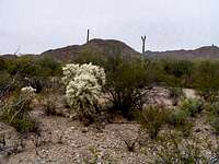
 Golden Gate Mountain from the desert below Brown Mountain in May
Photo by wyomingwapiti
While not grand in stature, Brown Mountain treats the hiker to diverse, spectacular Sonoran desert flora. Located in Tucson Mountain Park not far from Saguaro National Park (West), the views from the ridge line and summit of Brown Mountain are fantastic and make the hiker feel much further away than the western suburbs of Tucson. This great little mountain is convenient for residents of and visitors to the Tucson metro area, and combines nicely with other hiking nearby objectives while being a worthy destination in its own right.
Regardless of route, the ascent of Brown Mountain presents a delightful hike along undulating ridge with close-up views of Tucson Mountains and distant views of numerous other ranges far across the desert floor. The close-up experience of a wide variety of desert plant life is reason alone to plan a hike to Brown Mountain.
Note that there are two candidate high points: One summit to the southeast , more heavily trodden, seems favored by hikers as the highpoint and another smaller point to the northwest that seems to more closely coincide with the high point indicated on the map. Touch them both just to be sure!
Getting There
Tucson Mountain Park resides 13 miles to the west of Tucson. The park can be reached via Gates Pass Road or by taking Ajo Road to Kinney Way. |
 |
 |
Route Overview
Due to a wide selection of parking areas, trailheads and picnic spots, there are numerous options for routes to the summit of Brown Mountain. Below is a summary of three of these options.| Route | Approximate Mileage | Approximate Elevation Gain | Special Note | Driving Directions |
|---|---|---|---|---|
| McCain Loop Road Parking | 3 miles roundtrip (out-and-back) | 400 ft. | Enjoy ascent views of Golden Gate, Bushmaster & Tower | From Kinney Rd, look for signs to Gilbert Ray campground and head southwest on McCain Loop Rd. 1/2 mile; park on northwest side of road in small pull-out |
| Juan Santa Cruz Picnic Area | 2.5 miles roundtrip (out-and-back) | 350 ft. | Parking area includes pleasant picnic spots and a flush toilet | Southeast of the Desert Museum off Kinney Rd.; look for signs to Juan Santa Cruz picnic area. |
| Brown Mountain Loop | 5 miles roundtrip | 350-400 ft. | Lovely route that takes in the Brown Mountain ridge line and a rolling stroll on the desert floor | Follow above directions to either McCain Loop Rd. parking or Juan Santa Cruz picnic area. |
Red Tape
 Cholla, Suguaro & Shrubs
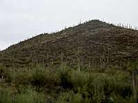 Brown Mountain from below
There is no entry fee for Tucson Mountain Park. The park is open daily 7:00 AM to 10:00 PM. Click here for full rules governing use of Pima County Parks.
Camping & Lodging
The only nearby campground is the 130-site Gilbert Ray Campground, located in Tucson Mountain Park.The proximity of Brown Mountain to the Tucson Metro area means lodging options are virtually unlimited. Visit the Trip Advisor site covering Tucson, AZ, for more information about area accomodations.
 Across the desert floor toward Gates Pass area
15 Feb 2009
Weather & Seasons
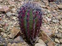 Young cactus pushing through rocky soil
15 Feb 2009
As with most lower elevation hikes in the Tucson area, hiking Cat Mountain would be most comfortable in the fall, winter or spring. March and April are primo wildflower viewing months.
Summer temperatures in this part of the Sonoran desert can be worse than uncomfortable; they can be downright dangerous! According to the United States National Weather Service, the record high temperature for Tucson, Arizona, set on 26th June 1990, was 117 degrees Farenheit / 47 degrees Celsius.
| Month | Avg High | Avg Low | Rain |
|---|---|---|---|
| January | 64.5 F | 38.9 F | 0.99 in. |
| February | 68.4 F | 41.6 F | 0.88 in. |
| March | 73.3 F | 45.1 F | 0.81 in. |
| April | 81.5 F | 50.5 F | 0.28 in. |
| May | 90.4 F | 58.6 F | 0.24 in. |
| June | 100.2 F | 68.0 F | 0.24 in. |
| July | 99.6 F | 73.4 F | 2.07 in. |
| August | 97.4 F | 72.4 F | 2.30 in. |
| September | 94.0 F | 67.7 F | 1.45 in. |
| October | 84.0 F | 57.0 F | 1.21 in. |
| November | 72.3 F | 45.1 F | 0.67 in. |
| December | 64.6 F | 39.2 F | 1.03 in. |
External Links
Tucson Mountain ParkPDF Map of Tucson Mountain Park