The page was successfully edited.

|
|
Route |
|---|---|
|
|
53.30052°N / 117.9039°W |
|
|
Ice Climbing |
|
|
Winter |
|
|
Half a day |
|
|
Grade 3 |
|
|
1 |
|
|
II |
|
|
Overview
This is an enjoyable little climb in a steep gully system giving it somewhat of an alpine feeling. There is only one longer pitch of climbing (about 35 metres) – the rest of the climb consists of short ice steps (which you may want to pitch out) or steep snow/ice. The climb provides ample exercise as you gain a considerable amount of elevation from your vehicle to the top. This climb can easily be combined in a day with one of the other Brule climbs such as Ogre Canyon or Ingredient 16.This climb may have been originally done long ago, but the record of this ascent has not survived. It is not found in Joe Josephson’s local ice climbing guidebook “Waterfall Ice”. The most recent first ascent occurred in 2009 – the entire route was soloed and named “The Condemned”.
The gully is steep enough to avalanche depending on conditions. When we climbed it there was no evidense of the gully having slid, but it was steep enough in places. Normally snow levels in this area around Brule are low enough that avalanche hazard is low.
The Approach
From Hinton Alberta, drive west (towards Jasper) approximately 3 km to the Highway 40 North turnoff. Turn right (north) on Highway 40. Drive for about 5 minutes until you cross the Athabasca River. Approximately one minute driving time from the Athabasca Bridge, there will be a turn off on your left to Brule. Take this road out to the small community of Brule – about a 15-20 minute drive from Highway 40. This is the view of the crux pitch, taken on the descent.
Once in Brule, drive through the community on the main road – after you past the last house, the paved road will turn into a dirt road and will be blocked by a gate. Set your odometer to zero at this gate. Open the gate, drive through it, and then CLOSE THE GATE. Drive another minute or so to another gate – open and close this gate as well. Approximately 3.0 kilometres from the first gate you will come to a large grassy opening (it’s obvious) – park on the right side of the road in this opening.
From this opening you want to head to the obvious drainages above you – “The Condemned” climbs the right most gully system. Walk through the grassy opening, crossing an old road – on the other side of this road is a barbed wire fence. Carefully cross this fence and then aim uphill bearing left at about a 45 degree angle. About 5 minutes from the fence you will come out into a dry gully. Follow this gully uphill for about 45 minutes – the hiking starts out fairly mellow and then gets steeper as you get closer to the mountain. At an obvious fork in the gully, follow the right hand fork (a subsidiary gully) for 100 metres up to the first short pitch. The ice of the first pitch can be seen from the fork.
It’s best to gear up for the climb and leave your pack, ski poles, and any other unwanted gear at the fork – this will avoid having to walk up to the first pitch to retrieve your pack (etc.) once you've descended.
Route Description
The first pitch of ice is about 8 metres high and vertical. If this pitch is not in shape, the gully can be regained by climbing up to the right until a break in the rock wall can be scrambled over. Then make a somewhat exposed traverse back into the main gully.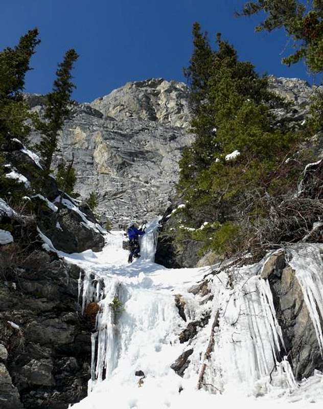 The last short ice steps near the top of the climb
After the first pitch, climb the gully on snow and ice (crampons required) for approximately 200 metres until another five metre short section of grade 2 ice is encountered. Climb this ice and continue up the gully.
About 50 metres from the top of the grade 2 ice, the gully turns sharply to the left and then ends at a 35 metre headwall.
Climb the straightforward, but enjoyable, grade 3 pitch belaying on any of the small trees on climber’s right – immediately before the next short section of ice.
The next short pitch is about 7 metres long with a scraggly tree on its left hand side near the top. Climb this section, belaying on trees on the right.
From here, it is another 150 metres up to the final short steps of ice – these can be soloed or pitched out depending on your comfort level.
The climb ends near the base of the large imposing limestone headwall – part of Mount Brule. The views from the top of the climb are quite impressive.
Essential Gear
 The view from the top of the climb.
One sixty metre rope and a selection of ice screws. No rappels are required.