
-
 16611 Hits
-
 88.51% Score
-
 27 Votes
|
|
Mountain/Rock |
|---|---|
|
|
37.07843°N / 91.19978°W |
|
|
Hiking |
|
|
Spring, Summer, Fall, Winter |
|
|
1348 ft / 411 m |
|
|
Overview
Stegall Mountain is one of the higher “mountains” in the Missouri Ozarks. Those of you on the coasts would call it a “hill,” but here in the Midwest we take what we can get. Like many other peaks of the Ozarks, it’s actually part of a large plateau that has been eroded by rivers and streams as opposed to being created by uplift.It’s a long formation with two summits, both above the 1300 foot contour line. One summit has a road that reaches almost up to the summit, with a lookout tower. I’ll call that “Stegall L” for “lookout.” The other is a short diversion from the Ozark Trail, and I’ll call it “Stegall T” for “trail.” I’ve been to the top of Stegall T but not Stegall L, since I’d rather hike than drive to a summit. For various reasons I’ll guess that Stegall L is a little higher.
The sightlines from Stegall T are as good as you get in the Ozarks. There are open views in some directions, while many views are partly blocked by trees and other vegetation.
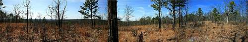 View to the west
Natural history
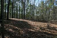
 Stegall Mountain Glade
The summit of Stegall T is a wide, largely-open glade. There’s widespread evidence of low-intensity fire, which might be lightning caused but my guess is that this is a management fire. The Missouri Department of Natural Resources is working to reestablish various microhabitats in the region as part of returning the area closer to natural conditions.
The summit of Stegall Mountain is the largest “glade” in the Lower Ozarks. A glade is a distinctive habitat common in the Ozarks. These open, rocky areas on or near the tops of hills have thin soils and high exposure to the sun. This creates a semi-arid environment with few trees, characterized by native grasses and forbs. Desert plants such as prickly-pear cactus can be found here, as can tarantulas and other desert species.
The abundant insects also make the glades a good habitat for various species of lizards, including the endangered eastern collared lizard, normally found in the desert southwest. This lizard is more typical of the American Southwest and northern Mexico, but it finds a home in the dry, rocky, exposed “glades” on top of many Ozark peaks.
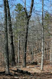
 Stegall Mountain View
That lizard lets me tell a more general story about the region. Much of the Ozarks were logged out early in the 1900s, but the state and federal governments began to replant in the 1930s and 1940s. To protect the trees, state and federal agencies also suppressed fires in the region. Forest restoration in the Peck Ranch Conservation Area was slowly squeezing out the glade, as brush and trees moved upslope during the era of fire suppression from the 1930s. Missouri DNR reintroduced the eastern collared lizard onto the mountain in 1983-89, using stock from the Taum Sauk region that was threatened by proposed developments. However, the population did not thrive as the glade continued to close in. Controlled burns since 1993 have helped to keep the glade microhabitat open.
Because the glades are isolated from one another, they are essentially “island” habitats that rely on corridors to keep them connected in a metapopulation. The eastern collared lizard population from Stegall has since dispersed to other glades, confirmed by DNA studies. It’s a nice story about how reintroducing flora and fauna, and then helping natural processes like fire, can start to restore an ecosystem.
Route
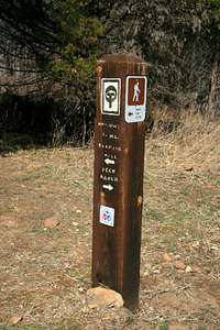 Junction sign
You’ll hike for a couple miles through wide bottomland before beginning an ascent to a ridge. This uses a mix of switchbacks and traverses to reach the top of a ridge where you’ll see an unmarked two-track on your right.
 Go left here
The OT continues ahead. The map shows the OT ascending a shoulder of Stegall T but not reaching the summit. However, the Carroll and Welch guide claims that the trail reaches the summit. Wanting the summit more than the OT, I turned onto the two-track. It quickly reaches a small knob and then forks; go left. You’ll descend a little, and you may see the OT paralleling you. Then the two-track ascends sharply to a saddle, and a T junction of two-tracks. Go left and reach the summit in 200 yards or so.
I suspect that turning right connects up with Stegall L after a half-mile or so. However, none of the two tracks are marked on the map so it is impossible to be sure.
Getting There
 Trailhead at Rocky Falls
Stegall Mountain lies just off the Current River Section of the Ozark Trail. There are large trailheads at each end of this segment, at Powder Mill on Highway 106 in the north, and just off Highway 60 west of Van Buren in the south. There are various other trailheads but if you want to do this as a day hike, use Rocky Falls.
To get to Rocky Falls from the south, take US 60 west of Van Buren to Winona, and then go north on State Highway H to State Highway NN. From the north, take State Highway 106 east from Eminence or west from Elliston to H, then to NN. The turnoff to the Rocky Falls day use area is clearly marked in both directions.
Red Tape
Most of the mountain and the approach trail is part of the Peck Ranch Conservation Area, owned by the State of Missouri. This is a popular hunting destination and is closed to hikers several weekends each fall. Call the Wildlife District Supervisor of the Ozark District Office for details, 417-256-7161.The shortest trail approach begins at Rocky Falls, a National Park Service day use area. There is no entrance fee.
Camping
 Ozark two-track
The Ozarks are a hodge-podge of land ownership, with National Park Service lands (Ozark National Scenic Riverways), US Forest Service Lands (Mark Twain National Forest), State of Missouri conservation lands, State of Missouri natural resources lands, private conservation lands (The Nature Conservancy and the L-A-D Foundation), and private property being used for agriculture, livestock, and forestry. The trails all have public easements if they are on private land, so hiking is straightforward.
Camping regulations vary. The US Forest Service and Missouri natural resources lands allow dispersed camping at least 100 feet from a trail and 100 feet from a stream, and prohibit camping in glades. This is essentially the NPS rule too. There are a modest number of sites that attract repeated use, most of which are attractive, flat, have fire rings, and are in technical violation of these rules.
Missouri conservation areas, such as the Peck Ranch Conservation Area (PRCA) where Stegall Mountain is located, prohibit camping. It’s more than five miles out of the PRCA from Stegall’s summit, so be prepared to hoof it a ways.
Contacts and resources
 Three blazes on the OT
National Geographic, Trails Illustrated: Ozark National Scenic Riverways.
Ozark National Scenic Riverways (National Park Service)
http://www.nps.gov/ozark, 573-323-4236
Missouri Department of Conservation
http://www.mdc.mo.gov, 417-256-7161
 Klepzig Mill, a nearby attraction on the OT