
-
 7650 Hits
-
 85.87% Score
-
 21 Votes
|
|
Mountain/Rock |
|---|---|
|
|
47.42717°N / 11.19183°E |
|
|
7539 ft / 2298 m |
|
|
Overview
 From Lautersee
Despite its rough look the northern side offers a beautiful ascend route via the Gamsanger saddle. The route requires UIAA I climbing and has some quite exposed sections but no real difficulties. Do not expect to be alone on this mountain on a fine summer day.
The northern side of the mountain has seen history in 1805 when the French army lead by Napoleon attacked the Porta Claudia fortress on the slopes of Große Arnspitze. The fortress withstood the attacks of the French army so Napoleon lead a part of his army into the Leutasch valley and attacked from the back and won the battle. Local hunters revealed the trail to Napolen and it is called Franzosensteig (French trail) today. Parts of the old fortress can be visited in Scharnitz.
Due to the location of the mountain at the end of the Wetterstein ridge, the summit has a stunning panorama into all directions. The Gamsanger route to the top is great fun to climb and a swim in one of the lakes during descend helps cooling down before enjoying a beer looking at the mountain. Summing all up, Obere Wettersteinspitze is an easily overlooked mountain which is definitely worth a visit.
Routes Overview
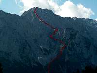 Gamsanger saddle route
- Gamsanger
Starting at Mittenwald you have to take one of the trails up to Lautersee lake. From there follow the signs "Franzosensteig" and "Obere Wettersteinspitze". Leading steeply up into the scree the trail traverses the steep and rocky face of the Gamsanger saddle. From there easy climbing (UIAA I) leads quickly up to the summit. - Kar "Im Flecken"
Starting in the Leutasch valley this route is completely unmarked and leads up the south face (UIAA I climbing and easier). - Traverse to Untere Wettersteinspitze
Starting at the summit the route leads along the ridge to the about 200m lower summit of Untere Wettersteinspitze (UIAA III (places) and II).
Getting There

| By car: | Road 177 and B2 which connects Innsbruck (Austria) and Garmisch-Partenkirchen (Germany) runs through Scharnitz, Seefeld and Mittenwald. From Garmisch-Partenkirchen you have a highway connection to Munich and Innsbruck provides a conenction to Italy (Brenner) and Switzerland. |
| By train: | About every hour the train from Garmisch-Partenkirchen (Germany) to Innsburck (Austria) stops at Mittenwald and Scharnitz. From Garmisch-Partenkirchen you have access to the trains to Munich, Ehrwald (Austria) and Rheutte (Austria). Innsbruck is the gateway to Italy (Bozen/Bolzano, Verona). For more information visit the homepage of Deutsche Bahn for german and ÖBB for austrian train connections. |
Red Tape
There are no permits, fees or seasonal closures. The mountain is part of a nature reservation area so don't pick up plants and leave only footprints.Parking at the chair lift "Hoher Kranzberg" is not free and there are not too many places to park so be quick because on sunny days the parking lot fills quickly. Additionally there are some parking lots in Mittenwald like the "mountainbiker parking lot" or at the Karwendelbahn. From both places it is quite a distance to get to the trailhead.
Camping
| There are no huts close to the mountain. The closest hut is Meilerhütte but it is no option since you have to get down into the valley to get to any route leading up Obere Wettersteinspitze. The Gamsanger saddle on the north side looks like a nice place for a bivouac, though. |  Gamsanger saddle Gamsanger saddle |
Mountain Conditions
 Early spring
Weather conditions
- http://www.zamg.ac.at/wetter/prognose/tirol
Short term but very accurate weather forecast of tyrol. - Weather forecast of Mittenwald (www.wetter.com)
- Bavarian avalanche report
Unfortunately the avalanche report is available in german only.
Webcams
- http://livecam.feratel.at/cam/mittenwald/3080/index.jsp
Rotating webcam on the summit of Hoher Kranzberg. Sometimes Obere Wettersteinspitze is visible in the streaming version.
Maps And Books
- KOMPASS #5 - Wettersteingebirge Zugspitzgebiet (1:50 000)
ISBN: 978-3-85491-007-7
A good overview map of the hole Wetterstein area. The map can be bought at KOMPASS or Amazon. - AV-Karte 4/3 Wetterstein und Mieminger Gebirge, Ost (1:25 000)
ISBN: 3-928777-11-4
Detailed map of the area around Zugspitze and Alpspitze. The map can be bought at the DAV shop. - Stefan Beulke Alpenvereinsführer Wetterstein
ISBN: 3-7633-1119-X, Rother Verlag
Guide book of the hole Wetterstein range.
External Links
- http://www.zamg.ac.at/wetter/prognose/tirol
Short term but very accurate weather forecast of tyrol.