|
|
Mountain/Rock |
|---|---|
|
|
36.88680°N / 111.5918°W |
|
|
Coconino |
|
|
5148 ft / 1569 m |
|
|
Overview
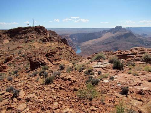
Point 5148 is an otherwise unnamed point that, in my judgement, has the best overall view of the Lees Ferry area: the meeting of Glen Canyon (Colorado River) and Paria River Canyon. The main ascent is by rough unmaintained trail (the Spencer Trail), and the rest of the route is easy to moderate hiking & scrambling on surfaces ranging from loose sand to finrock to bedrock. Total round-trip distance from Spencer trailhead (estimated from map) is slightly over 6 miles (about 10 km).
The hike will take much of the day at a leisurely pace. Start early enough in the morning so that the Spencer Trail is shaded - when the sunlight hits the rock it'll get hot fast!
Getting There
Lees Ferry, Arizona (part of Glen Canyon National Recreation Area) can be accessed from the north (Utah - St George or Kanab) or from the south (Flagstaff). Take US Highway 89 south from Kanab, turn east at Jacob Lake, drive ~41 miles (~67 km) to signed turnoff just before Navajo Bridge. From Flagstaff, take Highway 89 north and cross the Bridge, take the signed turnoff shortly after crossing.One can stop at the Navajo Bridge Visitor Center (Glen Canyon NRA) for inquiries - but this visitor center is closed during non-summer months (it was "closed for repairs" on my last visit in October 2014).
Route Description
The Spencer Trail starts in the Lees Ferry Historic District (east of the boat ramp); it is marked with a small sign. It climbs 1560 feet (~475 meters) over a distance of about 1.5 miles (~2.4 km). Allow 20-30 minutes of brisk walking each way from trailhead to the campground. The trail was constructed in 1910 for the purpose of hauling coal (by mule) to the river. At the most recent time I hiked it (Oct. 2014), several parts of the trail were damaged by rockslides. If the trail fades out, stop and look past the damage for where the trail resumes.
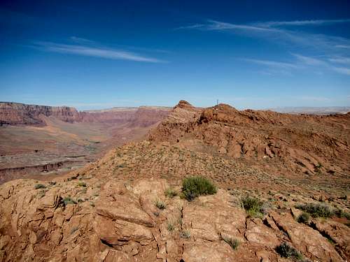
The upper end of the trail is marked by a large rock cairn - note its position and its surroundings. From the cairn, it is slightly over 1.5 miles (~2.4 km) to Point 5148'. Be sure to pause now and then to look around for desert bighorn sheep. Make your way west/northwest, following the canyon rim, and you will soon see a telecom site (accessed by a restricted road from Lake Powell):
telecom site.1Head toward that facility - if you don't want to check it out, skirt it to the north.telecom site.3
I found no way to the top of 5148 without a steep friction scramble - almost crawling up the smooth sandstone. The top affords a 360 degree panorama that will take some time to soak in.Return the way you came. An alternative is to continue NW along the rim of the Paria River Canyon, and descend to the Paria River by way of Dominguez Pass. This historic route was used by the Dominguez-Velez de Escalante expedition on November 2, 1776. It looks like a long difficult journey involving travel over sand dunes and involving a crossing of the Paria River to get back to Lees Ferry. I've not done it, but it looks like a 2 day affair.