
-
 14912 Hits
-
 85.87% Score
-
 21 Votes
|
|
Route |
|---|---|
|
|
45.92239°N / 7.79054°E |
|
|
Mountaineering |
|
|
Summer |
|
|
Half a day |
|
|
PD(+) |
|
|
Overview
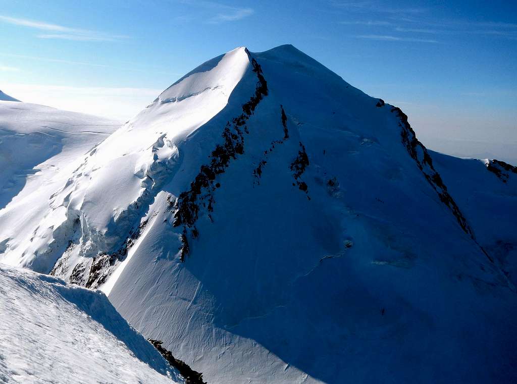
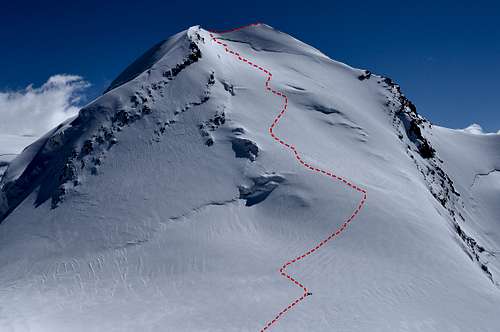
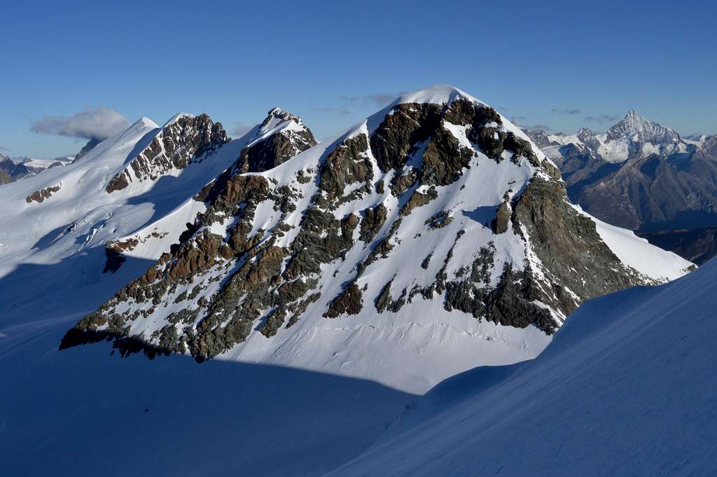
Excellent photo by Gimpilator showing Castor WNW flank in profile, in shade - from Pollux 2012
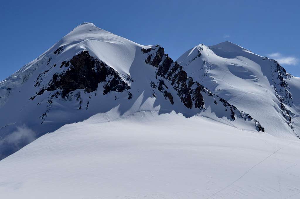
Castor 4223m is one of the most beautiful mountains in the Pennine Alps of Switzerland. It is well known as the higher of a pair of peaks known as Zwillinge – or ‘twins’ – the other and slightly smaller sibling being Pollux 4092m. It is an almost perfect snow peak but from certain angles looks distinctly dwarfed by some of the other peaks in the chain of mountains of which it is part – and which form the frontier ridge between Switzerland and Italy.
It is only on closer inspection that it becomes clear that Castor is no midget. At 4223m (13,851ft) it is very comfortably over 4000m and very nearly joins the elite group of 13 alpine mountains which top 14,000ft. Indeed in Goedeke’s 4000m guide Castor ranks 15th out of 51 in his list of 4000m mountains. In Martin Moran’s Alpine Club guide the ranking is similar at 27th out of his listed 85 peaks and subsidiary tops. It is the presence on the frontier ridge of multi-summited giants like Monte Rosa and Lyskamm which make the Zwillinge look rather small – apparently sandwiched in between Lyskamm and Breithorn. But the Breithorn, whilst also multi summited and very big, is actually lower in height than Castor by 59 metres.
There are a number of routes by which Castor can be climbed, varying from F(+) to AD(+). The mountain is heavily defended on its northern (Swiss) side by the complex Zwillings Glacier, which will be impassable through most of the summer and only a realistic option when under snow in winter or spring.
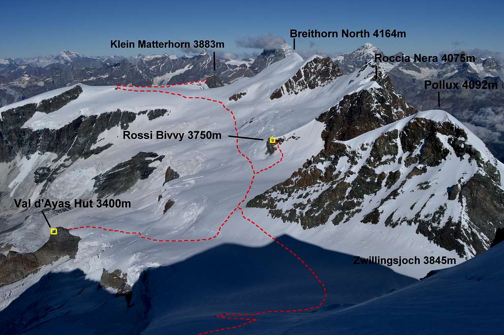
On the southern (Italian) east and west aspects Castor routes are much more open to approach. Access is via Klein Matterhorn in Switzerland or from the Quintino Sella, Testa Griglia or Val d’Ayas huts just across the border in Italy. In addition there is a tiny Italian bivouac hut Rossi e Volante situated at 3750m, on the southern aspect of the Roccia Nera (eastern) summit of the Breithorn. This is also a convenient launch point for routes on both Pollux and Castor and is in turn easily accessed from both the Klein Matterhorn and the Italian hut system.
The route described in this page is WNW flank of Castor. Graded PD(+) it is one of two ‘normal’ routes* for ascent of this fine peak. The final ascent is made from the Zwillingsjoch, a 3848m pass on western side of Castor and initially zig-zags up the glaciated western flank of the mountain, without much difficulty. The crux of the route is right up at the top. Firstly there is a potentially tricky bergschrund to cross, followed by a short steep slope. Then there is the star prize: 50 metres of some of the most perfect snow ridge in the Alps – a true knife edge. The only thing wrong with this part of the route is that it is over too quickly...
*The other ‘normal’ route is the SE ridge ascending from the other pass on eastern side of Castor, the Feliksjoch. This is graded F(+) and can be accessed from the Quinto Sella Hut.
Views of the Zwillinges (Twins) from the North:
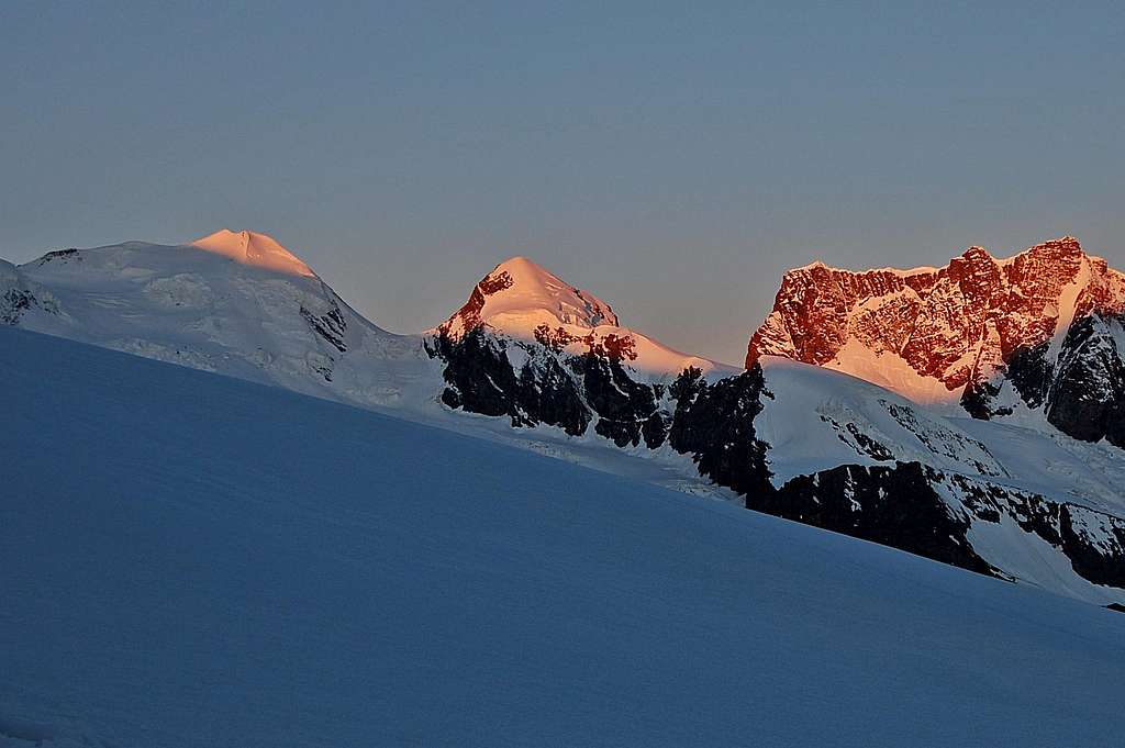 Castor & Pollux catching the alpenglow Gorner Glacier July 2013 | 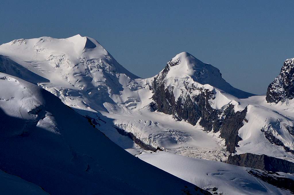 Castor & Pollux from Allalinhorn 2014 |
Getting there.
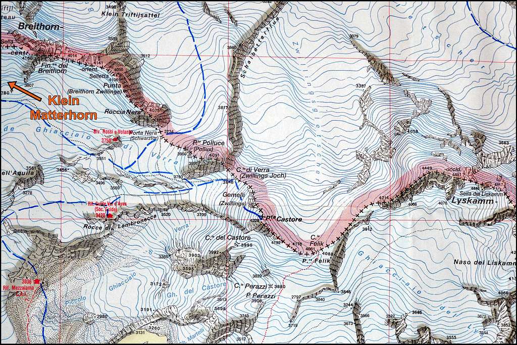
Castor connections - from IGC Sheet 109 1:25000 Monte Rosa Carte des sentiers et refuges
Access to Castor WNW flank is surprisingly complex. This is by no means due to technical difficulty – but due to the fact that there are several choices. With many Alpine routes it is a simple two stage procedure of a standard approach to a single hut (or camp) followed by the ascent of the peak. With Castor choices of game-plan include day ascent from Zermatt, walk or cable car up to one of a couple of mountain huts, overnighting in a high mountain bivouac shelter – and finally (and most aesthetically pleasing) the terrain lends itself to a tent based approach. So it is a matter of weighing up fitness and acclimatisation, studying the map (and finances) – and making a choice. In September 2014 I chose the Rossi Bivouac Shelter. This was a socially interesting experience (see Alps International Expedition 2014) but if I were doing it again, I’d take a tent and camp.
For most the main point of access for Castor WNW flank is the Klein Matterhorn 3883m on the Swiss side of the border with Italy. In turn this can be accessed from Zermatt via the greatest cable lift system in the Alps, rising up 2200m from the town at 1620m to just below the summit at 3820m (an elevator then ascends to viewing platform at 3883m, for those not inclined to go outside and walk up).
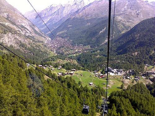 Klein Matterhorn cable way rising up from Zermatt | 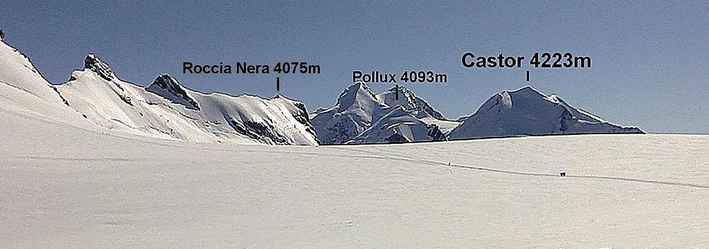 View of Castor & Pollux from Breithorn Plateau just a few hundred metres SW of Klein Matterhorn |
A similar but less extensive system rises up from Cervinia in Italy up to Testa Griglia at 3479m. This is about 300m lower and the top station is about 1 km to the west of Klein Matterhorn – and the two are connected via a circuitous 2 ½ km walk.
Castor (and Pollux) can be climbed in day trip from Zermatt or Cervinia using either lift system. It has to be said these options are for those who are not only fit, but also already fully acclimatised to the altitude. Those in not so much of a hurry can stay overnight at one of the options below:
T +41 (0)27 966 0101. Bunkroom with places for 30 – key will be required. Accessed via Klein Matterhorn cable car, a 1 ½ hour walk up from Testa Griglia or 3 ½ hour walk up from Trockener Steg at 2920m.
Testa Griglia Hut (Guide del Cervino) 3479m.
T +39 0166 948369. Accessed via Testa Griglia lift system from Cervinia. Places for 40.
Guide della Val d’Ayas Hut 3400m.
T +39 0125 308083. Also known as Rifugio Lambronecca. Places for 70.
Approach:
1) From St Jacques – a 5-6 hour walk first to Mezzalama Hut, before ascending Verra Glacier and accessing the hut.
2) From Klein Matterhorn – a 2-3 hour alpine route graded F(+). Add 1 ½ hours if from Testa Griglia. Approach traverses the southern slopes of the Breithorn in an easterly direction past the Rossi e Volante Bivouac (see detail below) before rounding the foot of Pollux SW ridge. At this point the Zwillingsjoch comes into view ahead slightly north of east – but route now angles sharply right just south of west to descend a glacial ramp descending in a westerly direction to reach the hut.
Rossi e Volante Bivouac Hut 3750m.
Places for 12. This is a very basic metal hut situated just below top and on south-eastern aspect of the rock buttress at the foot of the southwest side of Roccia Nera. Sleeping bags and cooking equipment are needed. There is no water supply and snow will need to be collected. It is my recommendation to take a large bag to collect all the snow likely to be needed, from a source as far away from the hut as possible – there are no toilet facilities and sadly the immediate environs may well be polluted (as in September 2014).
The Rossi Bivvy is an option for an overnight stay but can become very crowded and it can be advisable to arrive early to secure a place. Having experienced an uncomfortable night with 13 in the hut in low season I would suggest caution if considering a visit in high season – and camping may well be a better option.
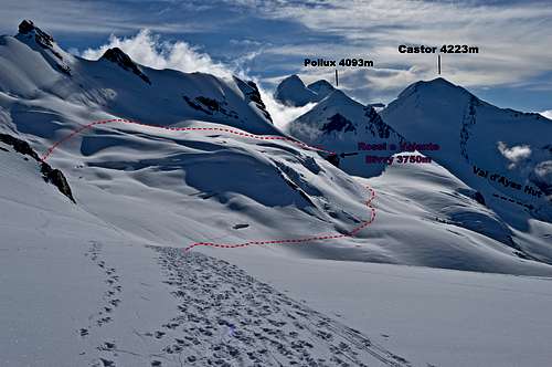 Route to Rossi Bivvy from W - click to enlarge | 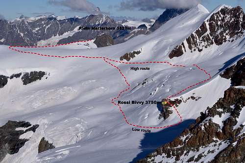 Access routes to Rossi Bivvy from E - click to enlarge | 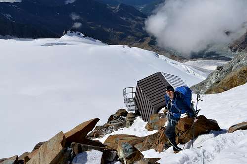 Rossi e Volante Bivouac Hut 3750m - camping possible on glacier below |
Camping
Below and to the SE of Rossi Bivvy is a glacial plateau bounded by Schwartztor 3734m col to the north and Pollux to the east. This area is relatively sheltered part of the Grande Verra Glacier and lends itself perfectly to a tent based approach. In September 2014 I could see signs of excavations in the snow looking down from the bivvy, which suggested that tents had been erected on the glacier recently.
Route description 1: to Zwillingsjoch
Distant view of Castor beyond Pollux from Rossi Bivvy - tracks in view - click on twice to enlarge fully
Route finding for this section of the ascent is not difficult. It is however somewhat difficult to describe, with such a choice of widely spaced starting places. Timings are similarly difficult to determine – other than to say that in no case does the overall outing involve a very long day – even for those who make the ascent and back from the valley bottoms of Zermatt or Cervinia, via the cable car systems. (It has to be a reasonably short day to make the last departure back down).
However, it does make for a moderately long day if the ascent is combined with an ascent of Pollux. Aesthetically this makes sense – they are ‘the twins’ after all – and you can’t leave one of them out...
From Klein Matterhorn 3820m: follow pistes in a southerly direction towards prominence of Gobba di Rollin 3899m, but before starting to ascend this angle left (east) after about 0.5km across Breithorn Pass 3814m.
There is likely to be a well established trail which soon divides into a left (northerly) fork looping round and up to the Breithorn main summit - or heading straight on. Continue straight on across the broad Breithorn plateau along southern aspect of the 3 summits of the Breithorn from main (western) summit 4164m to Roccia Nera (eastern) 4075m.
At some point the upper reaches of the Grande Verra Glacier is reached and the terraine becomes a little more undulating - and with some crevasse danger. The route continues to pass just below the little rocky bluff at the bottom of spur coming down from Roccia Nera - on which the Rossi Bivouac is situated, just below top of the eastern side of the bluff.
Continue across another glacier bay, below Schwarztor 3725m, towards the bottom of Pollux SW ridge. There is likely to be another fork in what through most of the season will be a well established trail with left branch heading for Pollux and the other, which is followed, around base of the ridge and thence towards Zwillingsjoch 3847m. From Klein Matterhorn 1 ½ - 2 hours (add another 1 ½ hours if coming from Testa Griglia).
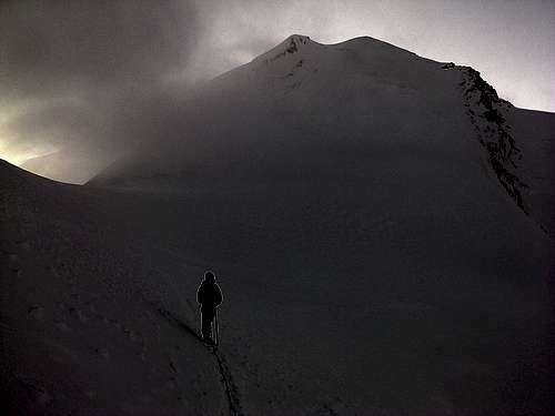
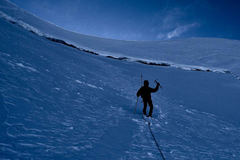
Spindrift blowing through Zwillinsjoch, ghostly view of Castor behind
From Val d'Ayas Hut 3400m: Ascend a sort of glacial ramp of the Grande Verra Glacier ENE and then E to join the Klein Matterhorn trail just to the east of the bottom of Pollux SW ridge - and thence towards Zwillingsjoch 38847m. From the hut about 1 - 1 ¼ hours.
From Rossi Bivvy 3750m: Descend the rocky scramble to SE, following a cleft, which may be part snow filled. The glacier is soon reached, with a bergscrund crossing to be made before joining the main 'Klein Matterhorn trail' and crossing towards and then round base of Pollux SW ridge to Zwillingsjoch 3847m. From bivvy 3/4 hour.
Topo of all the approaches to WNW flank from summit of Castor
Route description 2: WNW Flank
Castor 4223m WNW Flank
One drawback of climbing this route in the early morning is that with all bar the summit ridge being west facing the majority of the ascent is made in deep shadow.
Hazards: The west flank is prone to avalanche after heavy snowfall, in which case the rocky NW ridge at left (northern) edge rising immediately above the Zwillingsjoch, offers a safer alternative at same standard of PD(+). The summit ridge is very narrow and exposed and particular care will be required in windy or poor snow conditions.
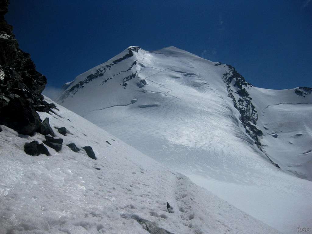
A couple of hundred metres short of the Zwillingsjoch 3848m the route angles south east towards the lower section of the west face of Castor. The exact line will vary year to year according to snow conditions and the state of the glacier. In September 2014 there was an obvious trail in the snow rising up in a series of switch-backs, starting at the middle of the face but thence forth keeping to left (northern) half.
At about 2/3 height there is a steepening, where overall angle increases from around 35° to 45° over a distance of maybe 50 metres. The angle then decreases to around 30° as a sloping glacial shelf is reached bounded up at top end by the bergschrund. The top is not far above now – but the next and last section is the crux.
The bergschrund is crossed at the optimum place – again this will vary year on year. In September 2014 there was a good solid snow bridge, albeit narrow and steep (55°), almost directly below the little col between north and south (main) summit. Above the big crevasse at this point all that remains of the west face is about 20m of moderate snow slope at 45-50° to reach crest of north ridge – and an almost astonishing emergence from deep shadow into brilliant sunlight, depending on time of day. If the crossing point is at a different place then some traversing may be required in addition to making the approximately 20m ascent up to the little col.
Having reached the little col the star prize is ahead. The north ridge rises up in a sublime snow crest to terminate at a perfect summit about 50m distant and about 30m higher. Either side slopes sweep down dizzyingly at an angle of around 50° - in shadow and down to the west flank to the right and in sunshine and down to the heavily crevassed Zwillings Glacier down to the left. It is one of those sorts of ridge where, as a rope of two, if one trips and falls off the other would need to jump over the other side to arrest the fall.
Timing: About 1 ½ hours from Zwilligsjoch to summit - an hour to the bergschrund and then half an hour to climb from there to summit.
 Bergschrund top of Castor WNW flank - exit top L - summit top R | 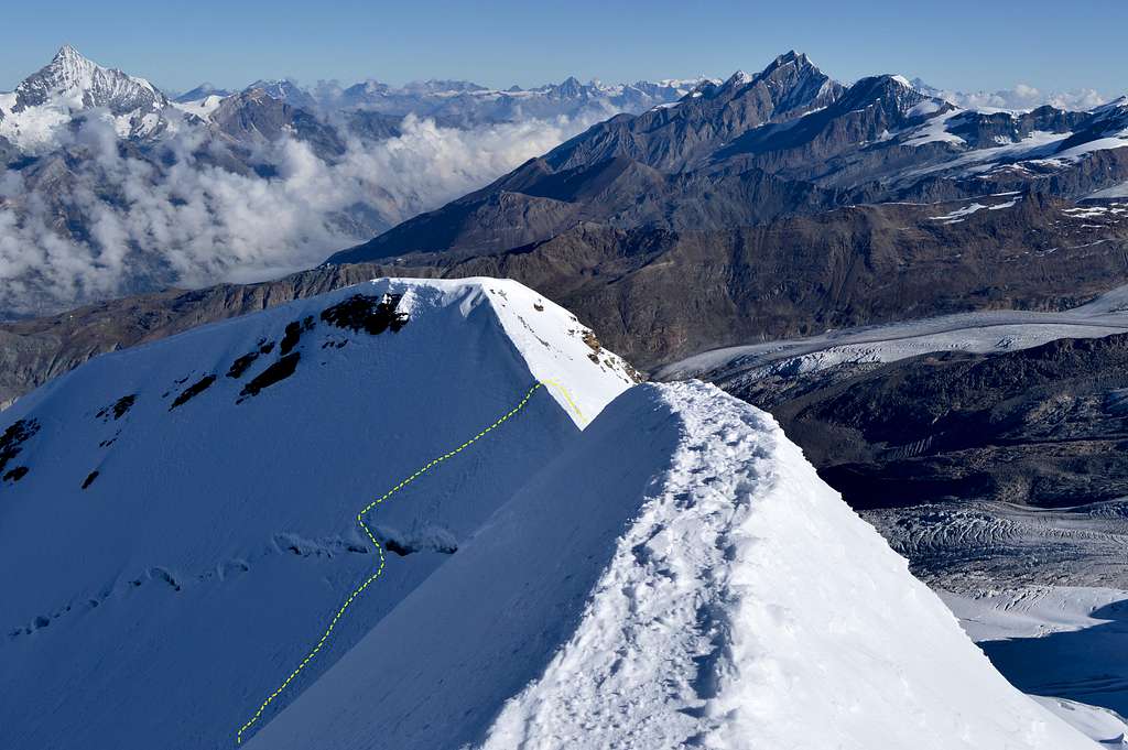 Castor 4223m summit view of Bergschrund crossing in 2014 |
The beautiful ridge is over all too soon – and the perfect snow summit is reached at almost geometrically precise confluence of the three summit ridges – north, south-west and south-east. Thus the highest point is a small flat triangle not much larger in area than a dining room table. Summit views don’t get much better. There is an astonishing 360° vista of plunging glaciers and deep green valleys far below – and shining white peaks 60km away as far as Bernese Oberland to the north and Gran Paradiso to the south – and to the majestic bulk of Mont Blanc some 75km away to the west. Somewhat closer pretty much all of the main summits of the Pennine Alps are in view. The only one missing is the Monte Rosa – hidden behind the twin summited giant of Lyskamm.
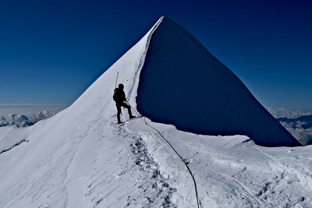 The glorious final crest to Castor summit 4223m | 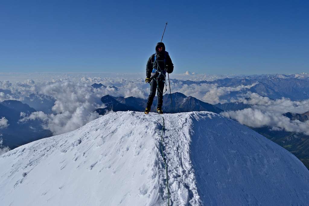 Castor summit 4223m - perfect apex of 3 ridges |
Alternative finish: via SW ridge
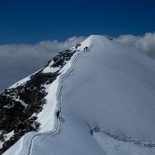
rgg image: Castor WNW flank with tracks exiting via SW ridge
rgg image: high on Castor SW ridge, difficult section far below
My companion on three alpine trips rgg has advised me that when he climbed Castor via the west flank in July 2012 he (with gimpilator and others) didn't exit left (north) and finish via the spectacular section of north ridge described above. Instead they headed on the opposite direction, to the right (south) and thence joined the upper section of the south-west ridge - and what looks to be an easier finish. Looking at Rob's photo to the left - that is where the tracks were going that year - perhaps due to the state of the bergschrund at the top of the face.
Given the easier and less exposed terrain at the very top of the southwest ridge (see Rob's photo to the right) I would suggest that if this route is followed the overall grade of the route would be easier than the PD+ given for the more standard finish via the more exposed north ridge.
Note however that the entire southwest ridge from the very bottom is much more difficult in the lower 2/3 section - and the overall grade for that route is D. Rob's photo of climbers on the upper part of the SW ridge shows this much more severe section in the background - the view is slightly misleading in that the lower ridge somehow looks to be higher than the viewpoint. However a close look at the climbers in the foreground and their angle to the slope, makes it clear that the section is actually far below.
Descent
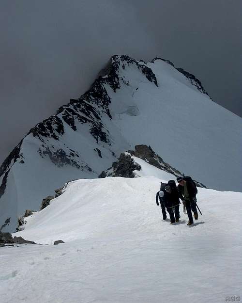
rgg image: Climbers descending Castor SE ridge
Return via the route of ascent is straight forward – but some care will be required reversing the little summit crest and re-crossing the bergschrund. Further care may be required back down on the Grande Verra Glacier in the afternoon, when the sun may have softened snow-bridges over crevasses etc.
Some additional energy will need to be found if Pollux is to be climbed, as I did with my son in September 2014. I have the impression that many tackling both the Zwillinge in a day will do it the other way round and climb Pollux first – perhaps making an ascent of the south-west ridge (normal route PD+ III) and descending to the Zwillingsjoch via the south-east ridge (PD+).
An aesthetically pleasing alternative to returning from Castor via the route of ascent would be to traverse the mountain and descend to the Quintino Sella Hut 3585m via southeast ridge, also said to be a gem of a route and a little easier at F(+) - see rgg photo to the left. From here a complete traverse of the frontier ridge could be continued with a traverse of Lyskamm 4527m...
 Looking back at Pollux 4092 from half way up Castor WNW flank | 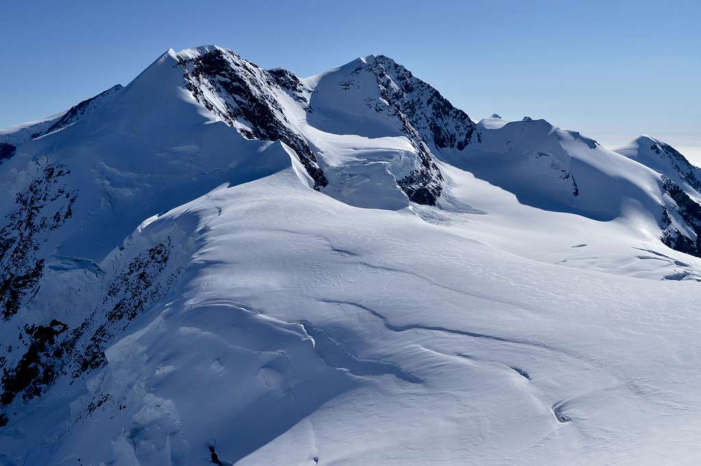 Twin summits of Lyskamm 4527m as seen from Castor summit |
Equipment
Normal alpine attire in anticipation of a cold pre-dawn start – and potential for cold and wind on the upper part of a high alpine peak. Summer alpine temperatures at 3-4000m in the early morning can easily be at around minus 10°C or colder - and if the wind-chill effect is added, the potential for extreme conditions is real. Enough layers of clothing need to be available, with a wind-proof outer layer and snow-gaiters - and attention needs to be given to headwear and hand/finger protection. Sunglasses/snow goggles should be strength 4.
Crampons, ice-axe and walking poles.
Rope (minimum 50m between a party of 2-3) and harness
Crevasse rescue equipment – depending on personal preference – but at a minimum all should carry prussic loops and should know how to use them.
Map, compass/GPS
Safety equipment – headtorch, first aid kit and whistle.
Rescue Insurance is mandatory.
Additional Information
External Links:
Mountain Rescue
International Rescue number 112
Swiss Police 144
Maps
1:25000 Swiss Topo LKS 1348 Zermatt
1:50000 Swiss Topo LKS 5006 Matterhorn-Mischabel
1:25000 Italian Carta dei sentieri e dei rifugi No 109 Monte Rosa, Alagna Valsesia, Macugnaga, Gressoney
Guide Books
The 4000m Peaks of the Alps. Martin Moran. Revised and re-printed 2012 by UK Alpine Club.
The Alpine 4000m Peaks. Richard Goedeke. Revised 2006.
German: Walliser Alpen Gebietsführer, 14th edition, 2012, Marianne Bauer & Michael Weber, Bergverlag Rother, ISBN 978-3-7633-2416-3