

-
 17110 Hits
-
 92.31% Score
-
 38 Votes
|
|
Canyon |
|---|---|
|
|
37.35051°N / 112.94907°W |
|
|
Hiking, Canyoneering |
|
|
Spring, Summer, Fall, Winter |
|
|
Overview
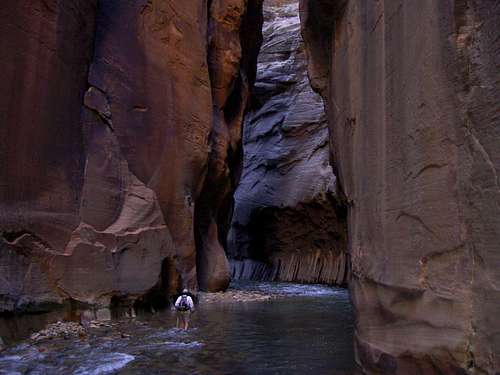
The Virgin River Narrows refers to the river-carved canyon etched deep into the Utah landscape in the northern area of Zion National Park. The North Fork of the Virgin River runs south from Navajo Lake at 9200 feet elevation, 11 miles to Chamberlain Ranch, 5900 feet elevation, where the top-to-bottom through-hike of The Narrows begins. Covering all 16 miles will lead you through a varied terrain of beautiful multicolored rock, blue-green water, an occasional spring or waterfall, and vegetation made to seem greener by its rarity. The river here at Chamberlain Ranch is really a small stream bordered by forest and meadow, which continues west until a gorge starts to form within 2 miles. From here until the confluence with Deep Creek, passing into Zion National Park in the process, 8.5 miles from the Chamberlain Ranch, the walls grow to reach up to 1300 feet, sometimes only ten to twenty feet apart. The combined river then turns south where the wall height becomes continuous for quite a distance. The gorge from here down has vertical sandstone walls from 40 to 100 feet apart, with occasional pockets of forest on both sides. From Deep Creek to Big Springs, an obvious oasis of vegetation and cascading water is 2.7 miles. At Big Springs, the canyon narrows again, and the true Narrows begin. For most of the next 3.6 mile stretch to the Mouth of the Narrows, the river runs wall to wall, often requiring wading and swimming. A mile south of the Mouth of the Narrows is the Temple of Sinawava, where the river enters Zion Canyon, a flat-floored, quarter to half-mile wide canyon with steep sandstone mountains on each side, their summits towering above. This is where day hikers venture north into the Narrows for a stunning, albeit abridged glimpse of the beauty within. Eight miles further south, where the canyon widens again, is the town of Springdale and the southern boundary of Zion National Park.
Getting There
 Virgin River Narrows
 At the confluence of Deep Creek
Most trips to Zion National Park start in Springdale, Utah, where there is plenty of food and lodging available. Directions to Springdale are as follows:Directions to Springdale from the North: From Salt Lake City travel Interstate-15 south. Exit to hwy 20. Follow highway 20 to hwy 89 towards Panguitch, then past the turn-off to Bryce Canyon. Continue on hwy 89 past the turn-off to Cedar Mountain (Cedar Breaks) and continue to Mt. Carmel Jct. At the junction of hwy 9 & 89 (Mt. Carmel Jct.) turn east. Follow the road for 12 miles to the east entrance of Zion National Park. Follow hwy 9 down through the tunnels and beautiful switchbacks until you reach the valley floor. If you continue to follow hwy 9 you will leave Zion National Park and arrive in Springdale miutes later.Directions to Springdale from the South: From Las Vegas, Nevada travel Interstate 15 north past St. George to Exit 16. Drive through Hurricane, Utah. Follow Hwy 9 through Hurricane and to the only stop light in LaVerkin. Turn right at the stop light. Continue on Hwy 9 to Springdale.Getting from Springdale to the individual Virgin River Narrows trailheads will follow in the attached routes.
When to go?
|
|
1=least 10=most |
(degrees f) |
1=least 10=most |
1=lowest 10=highest |
open? |
Open? |
|---|---|---|---|---|---|---|
| January | 2-4 | 40-45 | 1 | 1-2 | Mostly | Rarely |
| February | 2-4 | 40-45 | 1-2 | 1-2 | Yes | Rarely |
| March | 3-7 | 40-45 | 3-5 | 1-2 | Yes | Rarely |
| April | 4-10 | 45-50 | 4-6 | 3-4 | Mostly | Sometimes |
| May | 3-7 | 50-55 | 5-7 | 3-4 | Yes | Mostly |
| June | 2-4 | 55-60 | 6-8 | 3-4 | Yes | Yes |
| July | 1-3 | 60-65 | 7-10 | 5-8 | Yes | Yes |
| August | 1-4 | 60-65 | 7-10 | 5-10 | Yes | Yes |
| September | 2-4 | 55-60 | 5-8 | 5-10 | Yes | Yes |
| October | 2-3 | 50-55 | 4-7 | 3-4 | Yes | Yes |
| November | 2-3 | 45-50 | 3-5 | 1-2 | Yes | Mostly |
| December | 2-4 | 40-45 | 2-3 | 1-2 | Yes | Sometimes |
Red Tape
Back Country Permits are required for top to bottom hikes, overnight trips, or trips from the bottom up beyond Big Springs. The NPS limits permits to 40 per day, and parties no larger than 12.
Food & Lodging
 Big Springs
Food
Switchback Grille & Trading Co.Zion Lodge
Springdale Fruit Company
Mean Bean Coffee House
Flanigan's Inn
Zion Pizza & Noodle Co.
Lodging
Bumbleberry InnCanyon Ranch Motel
Desert Pearl Inn
Zion Park Motel
Driftwood Lodge
Pioneer Lodge
Flanigan's Inn
Canyon Vista Bed and Breakfast
Cliffrose Lodge & Gardens
El Rio Lodge
Zion Lodge
Under the Eaves B&B
Novel House
Weather
Flash Flood Warnings
