
-
 21724 Hits
-
 86.05% Score
-
 22 Votes
|
|
Area/Range |
|---|---|
|
|
43.60028°N / 122.03613°W |
|
|
Hiking, Mountaineering |
|
|
Spring, Summer, Fall, Winter |
|
|
5100 ft / 1554 m |
|
|
Willamette pass an area for all seasons.
The Willamette pass is an area of natural beauty as well as geologic diversity. The area is comprised of two distinct regions, One bieng the older and more eroded western cascades. The other the younger high cascades.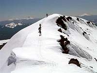
The western region features rugged subalpine ridges, deep forested canyons,and cascading rivers. The high cascade region is dominated by high volcanic peaks and large lake basins gouged by ice age glaciers.
The willamette pass is a year around recreational area. There is climbing, hiking,backpacking,camping,mountain biking,rafting and sailing during the summer months as well spring and fall. The winter features downhill skiing, backcountry skiing,and snowshoeing. The less physically active can enjoy the drive in campgrounds, rustic lakeside resorts with marinas. It's possible to rent moterboats to troll the lakes for elusive kokenee and mackinaw trout. Snowmobiles are very popular recreation in the winter months with hundreds of miles of trails.
The Volcanic Peaks
The centerpiece of the area for rugged beauty and its Highest summit isDiamondpeak at 8,744ft It resides within the bounderies of the diamond peak wilderness. There are no trails to its summit and in the winter and spring requires the use of ice axe and crampons. the use of a rope and navigation wands along the traverse near the summit if you are climbing in inclement conditions. The late summer offers up a good scramble to its summit. Another peak of note ismountyoranat 7,138 which offers some technical pitches with traditional protection on some routes. There are nine other summits above 7,000 ft in the area.
1)maidenpeak7,818ft
2)cowhorn 7664ft.
3)the twins 7,362ft
4)sawtoothmountain7,302
5)fujimountain7144ft
6)south mt yoran 7140.
7)odell butte 7,060 ft
8)lakeview mountain 7,065
9)Mt ray 7,002
These peaks are all walk ups with some class two and three scrambles on sawtooth and cowhorn mountains.
Waldo lake wilderness
On The north end of the willamette pass area is A precious jewel in waldo lakeIt is considered one of the purest large lakes in the world and sets at an elevation of 5,4ooft. The lake is popular with sailing enthusiasts as well as kayaks and canoes. the lake also has an 18 mile trail that circles the lake that is popular with mountain bike enthusiasts. the trail also links up with many hiking and backpacking destinations within the waldo lake wilderness. The lake is watched over on the east and south by four 7000 plus ft peaks. to the west the deep forested canyond of salmon and black creeks cascade down towards the willamette valley.
The high lakes
The area to the south and east of willamette pass contain three large lakes. The lakes are Odell, crescent and Davis. they are very poular with fisherman. The lakes have marinas, resorts and large camp grounds. Odell lake lies in a deep glacial trough just below willamette pass and is Surrounded by high forested ridges and peaks. Its waters are dark,cold and deep. The elusive lake trout also known as the mackinaw are exclusive to this lake. Crescent lake lies to the south east of odell. It"s a shallow lake with sandy beaches surrounded by pine forest. Davis lake is north east of odell and was formed by a large lava flow backing up its waters It situated between maiden and odell buttes and I believe is stocked with exotic German brown trout.
Oregon casdcade recreation area
the southern focus of this page, it is the highest and most remote with no all weather roads and no access during winter except for a very long ski in. It is the head waters area for the willamette as well as the deschutes river, and umpqua river drainage. About two thirds of this area lies above 6,500 ft and has six of the areas 7,000 plus peaks including diamond peak, it is also a large plateau sprinkled with hundreds of little lakes. The area is used by hikers, backpackers,climbers,mountainbikers,fisherman.
western mountains
Five miles west of the Willamette pass is the second highest waterfall in oregon. Salt creek falls plunges in one drop 286 ft in to a spectacular mist choked gorge covered in lichens and moss. There is a loop trail above the falls that takes in the gorge and other cascades with the climax bieng diamond creek falls plunging 80ft over a basalt cliff. The west cascades offer up fast moving streams great for kyaking and trout fishing. There are thermal springs sprinkled throughout the area. Two that are opened to public use are mcredie springs located off highway 58 at mile post 45/46 on the right side along salt creek. Warm springs located up salmon creek road on the east side of Oakridge is more secluded and more cozy. The middle fork of the willamette above hills creek resevior has many camp grounds which are staging grounds for great mountain bike trail rides,boating,fishing and gold panning. I have plugged in a link to The middle fork ranger district in the red tape section it offers up camping and points of interest information.
Getting There
From the willamette valley take interstate five either from the north are the south and take exit 188 state highway 58 klamath falls/central oregon. Drive thirty six miles to the town of oakridge and on the east end of town are two routes.To the south(right turn) is Kitson springs/hills creek resevior. Drive this road about half mile to a fork, take right fork road 21 summit lake. It is forty two miles to summit lake and the pacific crest trail. It's forty three miles to Timpanogos lake. The road gives access to southwest and south areas around diamond peak.
Take the left fork and this will take you up Hillscreek road which gives access to Mount yoran and north west approach to Diamond peak.
To the north (left turn) is the fish hatchery road. Follow this road for a mile and a half to road 24 salmon creek road. it gives access to the west and north side of the areas waldo wilderness.
To access the heart of the area continue east on state highway 58 towards willamette pass at mile post 62. along this easterly route you will come across access to salt creek falls on the right and north access to diamond peak wilderness.
A little farther up the road towards the pass, Waldo lake road exits left off the highway and accesses the lake, the waldo willderness and Pacific crest trail.
At the willamette pass mile post 62. the pacific crest trail crosses the highway. The willamette ski area is located here. Also west end of Odell lake.
from central oregon take state highway 97 from either Bend in the north or Klamath falls in the south. Take the willamette highway exit west bound towards Eugene. along the way west you will pass access to the south entrance to cascade lakes highway,crescent lake junction, east and west odell lake lodge and marinas before arriving at the pass. mile post62.
Red Tape
April 15th to december 15th a northwest forest pass is required for most trail heads. Access to wilderness requires an entry permit and they are available at all wilderness trailheads. All campgrounds require a fee. During the winter months a snow park permit is required for snow parks. Contactmiddle fork ranger districtfor recreation updates and changes in policies and procedures.Deschutes natl forest
External Links
Willamette pass ski resort.is a popular destination for alpine and telemark skiing. TheWillamette backcountry ski patrol The patrol maintains five back country shelters all with wood stoves fully stocked and a central warming and dispatch/first aid cabin at gold lake snow park. The patrol works with the alpine patrol in this area and creates a safe and informed skiing public. The pass area offers lodging atWillamette pass inn.
Shelter cove resort.
Odell lake resort.
Local weather forecast for willamette passNational weather service