
-
 35617 Hits
-
 79.49% Score
-
 11 Votes
|
|
Mountain/Rock |
|---|---|
|
|
43.55850°N / 122.13226°W |
|
|
Lane |
|
|
Mountaineering, Trad Climbing |
|
|
Summer, Fall |
|
|
7100 ft / 2164 m |
|
|
Alpine jewel

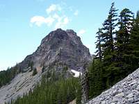
It is rugged and picturesque, and can be seen from many locations from Odell lake on the east side to the Salt creek tunnel west of Willamette Pass. Mount Yoran is a volcano that last erupted 400,000 years ago. The peak is an eroded shield volcano. The composition is Basalt and Andesite. What is present now is the weathered resistant plug.
The mountain is of interest to climbers. All profiles of the peak appear to have challenging lines. The peak By it's easiest route (south)is a loose class 3 climb with some fourth class potential if you dare! The north/east side has a doable 3rd class scramble, access is more difficult.
The peak does offer a couple of couliers that in winter/spring may offer some good snow climbing. a technical rock climbing ascent is possible, rock is questionable.
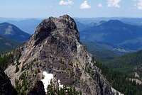
See the "Photos" page for a photo with the walk-up route shown.--(Walk-up route info courtesy of "zzril").
Getting There
Coming from the north or south on Interstate-5 take exit 188 east willamette hwy/Klamathfalls. Follow State Hwy 58 for 36 miles till you come to the town of Oakridge. After stopping for supplies and or gas proceed thru town until you reach milepost 38 take the right turn for Hills Creek resevior. Travel south for about .7tenths of mile. here you will come to a fork stay to your left. you are now on road 23, follow this for twenty miles till you come to Hemlock Butte/ Vivian lake trailheadTurn left at a hiker-symbol sign immediately beyond the pass and park at the Vivian Lake Trailhead.
Follow the trail about a mile to Notch Lake. Keep on going. At a trail junction about 0.2 mile, turn right on the Mount Yoran Trail (the trail does not ascend Mount Yoran). Follow the trail about 3 miles to Divide Lake ( a good spot to camp, as long as you stay at least 300 feet away from the lake or the nearby streams). Hike cross-country to the northeast of the lake to Mount Yoran's base.
In the winter, the best access to the mountain is to park at Salt Creek Falls. Navigate up the prominent drainage. Follow the RR tracks past a rock cut and then head up when it seems kind of marshy. I would recommend staying climber's left of the gully. This is about a 12 mi. R/T on snowshoes. Definitely bring ice axe, helmet, crampons. The North side has the potential to generate some SICK ice routes in the right conditions.--(Winter information courtesy of "zzril").
Popoff - Oct 17, 2002 6:51 am - Hasn't voted
Untitled Comment1) I do not know of any books that include routes on Mount Yoran, but 100 Hikes in the Central Oregon Cascades has the hike description to the Divide Lake, near the base of the mountain.
2) The peak is not a walk-up. It is rated a 5.1-5.2 in difficulty. However, the technical portion of the climb (the monolith) is on top of a hill. The hill is a simple walk-up to the base of the rock, but after that the route is technical.
rpc - Oct 17, 2002 8:46 am - Voted 10/10
Untitled Commentthanks.
can't wait to give it a go in that case (the 5.2 sounds like it could be fun).
rpc
Popoff - Nov 22, 2002 7:01 am - Hasn't voted
Untitled CommentThank you for the information. I will integrate it into the Mount Yoran text.
Popoff - Nov 22, 2002 7:05 am - Hasn't voted
Untitled CommentThank you for showing a route on the photo. It will help potential climbers.
Popoff - Nov 22, 2002 7:06 am - Hasn't voted
Untitled CommentThank you once again for all of your helpful information.
rpc - Oct 16, 2002 11:30 am - Voted 10/10
Untitled Commentnice page and a cool looking mountain (that I haven't heard of before)!
2 questions:
1. do you know of any books it is listed in
2. how technical are the routes to its summit - the mazamas web page description of it for instance claims that it's a walk up??
much thanks.
rpc
Popoff - Oct 17, 2002 6:51 am - Hasn't voted
Untitled Comment1) I do not know of any books that include routes on Mount Yoran, but 100 Hikes in the Central Oregon Cascades has the hike description to the Divide Lake, near the base of the mountain.
2) The peak is not a walk-up. It is rated a 5.1-5.2 in difficulty. However, the technical portion of the climb (the monolith) is on top of a hill. The hill is a simple walk-up to the base of the rock, but after that the route is technical.
rpc - Oct 17, 2002 8:46 am - Voted 10/10
Untitled Commentthanks.
can't wait to give it a go in that case (the 5.2 sounds like it could be fun).
rpc
zzril - Nov 21, 2002 12:24 pm - Hasn't voted
Untitled CommentThere is a 3rd/4th class scramble via a ramp on the southeast side of the peak. This ramp is accessible from both the North and South, with the South side being a bit more accessible.
zzril - Nov 21, 2002 12:32 pm - Hasn't voted
Untitled CommentI added some lines to the first photo submitted by Popoff to show the walk-up.
zzril - Nov 21, 2002 12:34 pm - Hasn't voted
Untitled CommentIf there's lots of snow, the trek is a bit more arduous, but can definitely be done in a day. Park at Salt Creek Falls and navigate up the prominent drainage. Follow the RR tracks past a rock cut and then head up when it seems kind of marshy. I would recommend staying climber's left of the gully. This is about a 12 mi. R/T on snowshoes. Definitely bring ice axe, helmet, crampons. The North side has the potential to generate some SICK ice routes in the right conditions.
Popoff - Nov 22, 2002 7:01 am - Hasn't voted
Untitled CommentThank you for the information. I will integrate it into the Mount Yoran text.
Popoff - Nov 22, 2002 7:05 am - Hasn't voted
Untitled CommentThank you for showing a route on the photo. It will help potential climbers.
Popoff - Nov 22, 2002 7:06 am - Hasn't voted
Untitled CommentThank you once again for all of your helpful information.