Background
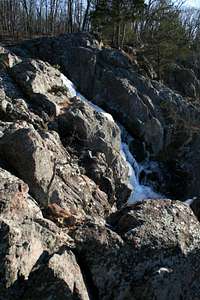
![Frozen Mina Sauk Falls]() Frozen Mina Sauk Falls
Frozen Mina Sauk Falls
We’ve had several weeks of good, cold weather here in the Lower Midwest, with daily highs from about 5 to 25. Fortunately, it looked as if the weather was going to break this past weekend, with highs in the 40s and overnight lows in the 20s. The time was ripe for us to make our assault on Taum Sauk Mountain, the Rooftop of Missouri at 1772 feet.
We arrived at Base Camp, also known as the Taum Sauk Mountain State Park parking lot, without needing to engage the four-wheel-drive option on our vehicle. We checked weather conditions, which seemed to be in the mid 40s, with clear skies. Avy danger was non-existent. We were glad to have waited for the break in the weather instead of attempting this assault earlier in the season.
After stowing our means of transport, we began our ascent. We made sure to remember where we had parked.
The Ascent
![The Via Concreta on Taum Sauk Mountain]() The Via Concreta
The Via Concreta
The standard route progresses 0.1 miles (0.16 km) through a deciduous forest. Because there were no leaves on the trees in winter, visibility conditions were excellent. The slope was quite moderate, and could be attempted backwards in roller blades.
Though Base Camp was unstaffed in winter, navigational aids such as trail signs, maps, and informational brochures were available outside the pit toilets.
It took us a few minutes to reach the summit.
A Dimensional Flux?
![Warning Sign on the Via Concreta]() Trail Sign on Via Concreta
Trail Sign on Via Concreta
After the successful ascent, we were still feeling rested and did not need to take advantage of the two park benches supplied by the state of the Missouri near the summit. We decided to continue on to Missouri’s highest waterfall, Mina Sauk Falls, which lie on the slopes of Taum Sauk Mountain.
The slopes of Taum Sauk Mountain seem to exist in a strange part of the space-time continuum. Just below the summit is a trail junction with two trails, both of which claim to go to Mina Sauk Falls. What makes the junction most curious, however, is that there are two signs giving different information about distances. According to the sign on the left, Mina Sauk Falls are 1.2 miles from the junction, while the sign on the right claims that they are 1.4 miles from the junction.
Thus, it appears that Mina Sauk Falls are both 1.2 miles away and 1.4 miles away from the exact same point. I have not yet seen an explanation of this phenomenon in the scientific literature.
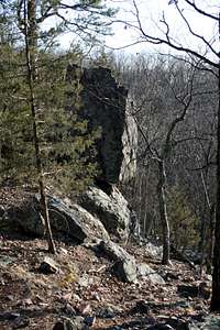
![Rocky Outcropping]() Rock Outcroppings
Rock Outcroppings
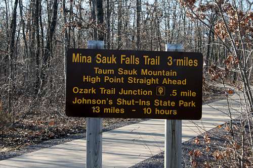
This dimensional flux may explain why Missouri State Parks labels the hike as “strenuous” and “moderately rugged.” Officials suggest that expeditions allow three hours for the 2.6 mile loop trail. Thanks to excellent acclimatization, we were able to complete it in a fraction of this time, with plenty of time for taking pictures.
Longer trails are available, as you can see from the attached sign. The signs warn that the 13-mile trail will take 10 hours, so be aware of the need for conditioning before attempting hikes in this area.
Missouri: better than you think!
Because the summit of Taum Sauk Mountain is the high point of a flat top, surrounded in trees, the views are lousy. However, the right-hand trail to Mina Sauk Falls takes you along the slopes of Taum Sauk Mountain, with views of Missouri’s deepest valley. It’s quite lovely, even in winter.
![Summit Monument]() Success!
Success!
Though its high point ranks lower in degree of difficulty than those of some neighboring states, thanks to its location on public land, it is located in a pleasant area. The southern half of Missouri consists of rolling hills and the Ozarks, mostly forested, with a large number of state park and national forest units scattered across the landscape. You’ll never confuse it with Colorado, but you won’t confuse it with Illinois or Indiana, either.
How the degree of difficulty compares with Mount Sunflower....difficult to say.


Comments
Post a Comment