
-
 1745 Hits
-
 79.78% Score
-
 11 Votes
|
|
Mountain/Rock |
|---|---|
|
|
37.95231°N / 106.94492°W |
|
|
Mineral&Saguache |
|
|
Hiking, Mountaineering |
|
|
Spring, Summer, Fall, Winter |
|
|
13300 ft / 4054 m |
|
|
Overview
 13300 and 13180
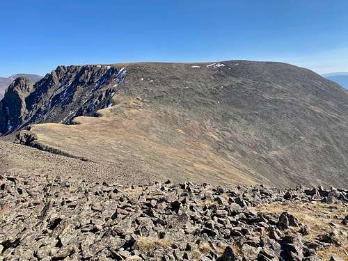 13300 A
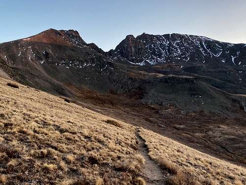
13300 is an unnamed peak near beautful historical town of Creede. The peak is located near the Continental Divide Trail and Colorado Trail, and provides great views of 14er San Luis. You can combine it with other nearby peaks. The unranked 13180 C peak is only 0.48 miles along a very rugged and loose ridge (most people prefer to descend below this ridge). My combination was 13300A with 13180C and 13155, adding a 14er San Luis would be easy, but I was running out of time. I will describe also route up 13180C in here. 13180C is an unranked peaks - the saddle between this peak and 13300 is less than 300 feet in prominence.
14ers.com specifies this peak as 13000 A. there are four unnamed 13300 peaks in San Juan Mountains of Colorado, and six peaks of this height in Colorado.
Why unnamed 13er? There are many unnamed peaks in Colorado, there are simply just too many peaks. Colorado has 676 ranked 12ers = peaks > 12,000 feet (=3657 meters), 584 13ers = peaks over 13,000 feet (= 3962 meters), and 54 14ers = peaks over 14,000 feet (= 4267 meters).
La Garita Wilderness spans 129,626 acres within Gunnison and Rio Grande National Forests. La Garita means "the overlook" in Spanish. It has only one fourteener San Luis Peak 14,014 feet. Many trailheads open approximately 175 miles of trails. About 27 miles of the Colorado Trail and Continental Divide National Scenic Trail follow the divide through La Garita Wilderness.
Colorado Rank: 395
Parent Lineage: San Luis Peak
Class: 2
Wilderness: La Garita
Nearby Peaks:
- Unnamed 13180 C 0.48 miles
- Unnamed 13155 1.70 miles
- San Luis Peak 2.50 miles
- Unnamed 13111 2.58 miles
Getting There
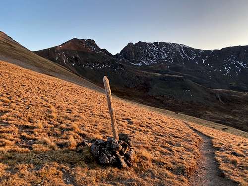
West Willow Creek Trailhead: located only about 9 miles north of historical town of Creede. Drive to Creede via CO 149. turn right onto Main Street and drive north through the town to join Loma Ave/Road 503. This section of the road is well maintained 2 WD dirt road. At 4.8 miles continue straight on 503 at a large intersection with Bachelor Road. Just past the intersection there should be a sign for Equity Mine. At 7.1 miles turn left on 503, signed for West Willow Creek Trailhead, and the from here you need 4WD vehicle. At 8.2 miles the road switchbacks down and crosses a creek. And at 8.7 miles you reach the trailhead. There are few campsites, and a small stream, no toilet facilities. The trail is starts here, and provides connection to Colorado Trail.
Route
 13300 and 13180 C
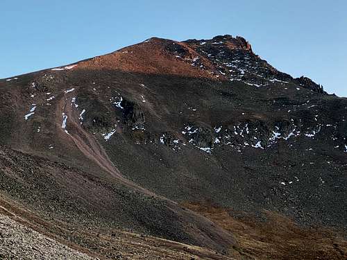 13180C
I chose to combine this outing with 2 other 13ers and had a pretty late start. From the West Willow Creek TH, I followed a nice trail - connector to Colorado Trail. Once I gained the saddle, I turned east and followed the mellow, mostly grassy slopes up 13300 over a false summit, large summit plateau to the actual hight point. There was a cairn and summit register. The vies of San Luis 14er are spectacular.
I dropped down from the summit of 1300 directly and descended a steep couloir with a lot of loose rocks (not recommended, but this would be a fun route if covered by snow). I dropped to a flatter area and crossed over a boulder feiled to ascend unranked unnamed 13180C peak. The northeast ridge is an easy acent, class 2 and the views are great. There is a register on its summit.
If you decide to continue onto 13155 - go here.
Red Tape
Hiking, climbing, camping are all free. Wilderness rules do apply. Leave No Trace have seven standards:
- Plan Ahead and Prepare
- Travel and Camp on Durable Surfaces
- Dispose of Waste Properly
- Leave What You Find
- Minimize Campfire Impacts
- Respect Wildlife
- Be Considerate of Other Visitors
When to Climb
Summer and early autumn are the easiest. Winter means a longer approach and avalanche danger. Early spring still has a lot of snow and no access to the 4WD West Willow Creek TH.
Camping
Wilderness camping is available just below the peak and along Colorado Trail. I camped at the West Willow Creek Trailhead. Basically, you can camp anywhere in the National Forest.