
-
 2075 Hits
-
 79.78% Score
-
 11 Votes
|
|
Mountain/Rock |
|---|---|
|
|
37.96741°N / 106.92028°W |
|
|
Mineral&Saguache |
|
|
Hiking, Mountaineering, Scrambling |
|
|
Spring, Summer, Fall |
|
|
13155 ft / 4010 m |
|
|
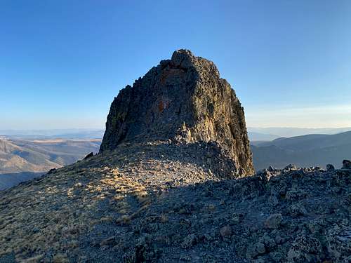
Overview
 13155
13155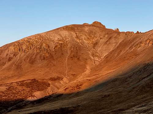 13155 alpenglow as seen from Colorado Trail
13155 is unnamed ranked 13er located south of a popular 14er San Luis. The peak is approachable via scenic Colorado Trail and in this part also Continental Divide Trail. There is a short 3+ scramble to reach its summit and the scree section is minimal. It is one of those peaks I would enjoy repeating multiple times over.
I chose to combine 13155 with 2 other 13rs: ranked 13300 and unranked 13180. A nice combination can be with 14er San Luis Peak.
Colorado Rank: 519
Parent Lineage: Line Parent 13300. Proximate Parent: San Luis Peak
Wilderness: La Garita
Class: 3+ (enjoyable and relatively short section of climbing)
Why unnamed 13er? There are many unnamed peaks in Colorado, there are simply just too many peaks. Colorado has 676 ranked 12ers = peaks > 12,000 feet (=3657 meters), 584 13ers = peaks over 13,000 feet (= 3962 meters), and 54 14ers = peaks over 14,000 feet (= 4267 meters).
La Garita Wilderness spans 129,626 acres within Gunnison and Rio Grande National Forests. La Garita means "the overlook" in Spanish. It has only one fourteener San Luis Peak 14,014 feet. Many trailheads open approximately 175 miles of trails. About 27 miles of the Colorado Trail and Continental Divide National Scenic Trail follow the divide through La Garita Wilderness.
Nearby Peaks:
- Unnamed 13180 A 1.22 miles
- San Luis Peak 1.48 miles
- Unnamed 13000 C 1.70 miles
- Organ Mountain A 2.14 miles
- Baldy Alto 2.62 miles
- Unnamed 13015 2.96 miles
Getting There
West Willow Creek Trailhead: located only about 9 miles north of historical town of Creede. Drive to Creede via CO 149. turn right onto Main Street and drive north through the town to join Loma Ave/Road 503. This section of the road is well maintained 2 WD dirt road. At 4.8 miles continue straight on 503 at a large intersection with Bachelor Road. Just past the intersection there should be a sign for Equity Mine. At 7.1 miles turn left on 503, signed for West Willow Creek Trailhead, and the from here you need 4WD vehicle. At 8.2 miles the road switchbacks down and crosses a creek. And at 8.7 miles you reach the trailhead. There are few campsites, and a small stream, no toilet facilities. The trail is starts here, and provides connection to Colorado Trail.
Route
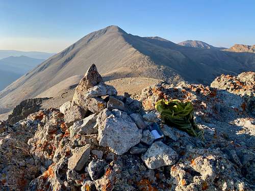 Summit of 13155 with San Luis Peak in the background
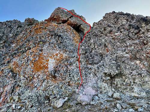 13155 - route of a short scramble.
I chose to combine this outing with 2 other 13ers and had a pretty late start. From the West Willow Creek TH, I followed a nice trail - connector to Colorado Trail. Once I gained the saddle, I turned east and followed the mellow, mostly grassy slopes up 13300 over a false summit, large summit plateau to the actual hight point. I dropped down from the summit of 1300 directly and descended a steep couloir with a lot of loose rocks (not recommended, but this would be a fun route if covered by snow). I dropped to a flatter area and hopped over large rocks/boulders to reach easier terrain leading to the unranked 13180 peak. From the summit of 13180 I was considering to continue on the ridge towards 13155, but within 300 meters of the 13155 I encountered some very loose terrain and exposure. I released a few rocks there and opted to drop down to Colorado Trail for a safer route (solo hike, late in the day). I moved fast on the trail and ascended north facing grassy slopes of 13155. The final summit block was really fun. The rock was climbed and relatively stable and clean. The summit is small, had a small cairn and summit register. The views of 14er San Luis and Organ Mountain are outstanding. Highly recommended adventure! Return back via nice Colorado Trail.
Red Tape
Hiking, climbing, camping are all free. Wilderness rules do apply. Leave No Trace have seven standards:
- Plan Ahead and Prepare
- Travel and Camp on Durable Surfaces
- Dispose of Waste Properly
- Leave What You Find
- Minimize Campfire Impacts
- Respect Wildlife
- Be Considerate of Other Visitors
When to Climb
Summer and early autumn are the easiest. Winter means a longer approach and avalanche danger. Early spring still has a lot of snow and no access to the 4WD West Willow Creek TH.
Camping
Wilderness camping is available just below the peak. I camped at the West Willow Creek Trailhead. Basically, you can camp anywhere in the National Forest.