The Attraction of Big Iron
They say there’s no educational value from the second mule kick. Every time I have done an ascent of Iron Mountain #1, I have promised myself there would be no “rematch.” After all, there are always plenty of new peaks to do without repeating yourself. And certainly I’m no competitor when it comes to multiple ascents of Big Iron. This last time on the summit, I saw in the register the name of someone I know with the notation “14x.” This is Mars Bonfire, a Sierra Club leader, and writer of that 1960’s classic “Born to be Wild” (“I like smoke and lightning, heavy metal thunder”). I have no desire or intention of trying to catch Mars in ascents of Iron.
Yet, there is something about Big Iron that draws you like a magnet (no pun intended). It will certainly kick your butt if you’re not ready for it. That’s an attraction in itself for those who feel ready. Probably no single peak in the San Gabriel range turns back more hikers than this one. After all, the round-trip is 14 miles with 7,200 feet of gain. Check out the SummitPost log for this mountain. Some formidable SP’ers have acknowledged that this is one tough hike.
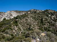
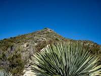
What else explains the allure of Iron? A beautiful route after you pass the big saddle at about the 4-mile mark. The ridge stretching in front of you winding to the summit is an awesome sight. To your right, majestic Big Horn Ridge sweeps northeast towards Mt. Baldy. To your left, Mt. Baden-Powell claims the vista northwest.
![Part of South Ridge Route to Big Iron]() Part of South Ridge Route to Big Iron
Part of South Ridge Route to Big Iron![Looking East toward Mt. Baldy and Big Horn Ridge from Iron Mtn.#1 s South Ridge]() Looking East towards Mt. Baldy and Big Horn Ridge from Iron's south ridge
Looking East towards Mt. Baldy and Big Horn Ridge from Iron's south ridge![Looking East Towards Mt. Baldy from South Ridge Iron Mtn.#1]() Looking East towards Mt. Baldy from Iron's south ridge
Looking East towards Mt. Baldy from Iron's south ridgeCaveats for First-Timers
First-timers should note that the route from Heaton Flat has a beguiling first half. The first 4 miles on the trail can lull you into a false sense of security: “Halfway there already? I feel pretty good. Bring on the rest!” And the mountain seems more than happy to accommodate you.
If Big Iron is going to deny you, it will probably toy with you first. If you’re in good shape, it will allow you to get within a mile of its summit. Naturally, after you’ve already done seven miles, one more is something almost everybody thinks is within their “suck it up” range. But this mile has 2,000 feet of gain: that’s 1000 feet per half mile and 500 feet per quarter mile. Ouch! After having humped the rugged terrain for several hours already, this mile can break the camel’s back. So it was for four of the nine members I was with this past Sunday.
Turned Back Only Once in 6 Attempts
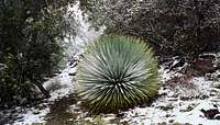
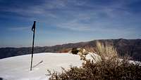
Only once was a successful summit not in the cards for me. On February 18 of this year, a small group I was with retreated about 5 miles into the hike when falling snow began to obliterate the use trail and, the coup de grace, white-out conditions ensued. However, the very next week, on February 25, the weather cooperated and we had a beautiful climb to a snow-covered summit. We got lucky again on April 23 when the route was blanketed with snow past Allison Saddle to the summit. Below are some photos of what the route looked like on these wintry ascents in February and April.
![Ridge Below Iron Mtn. No. 1]() Ridge area just below Iron's summit on April 23, 2006
Ridge area just below Iron's summit on April 23, 2006![Snow Dusted Yucca]() Snow dusted yucca on Iron's ridge route April 23, 2006
Snow dusted yucca on Iron's ridge route April 23, 2006![Summit of Iron Mtn. #1 (8,007 ), San Gabriel Mtns.]() Iron's snow covered summit on Feb. 25, 2006
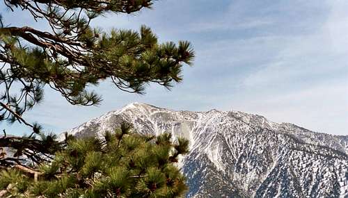
Iron's snow covered summit on Feb. 25, 2006![Mt. Baldy, San Gabriel Mountains]() Mt. Baldy from Iron's south ridge, Feb. 25, 2006
Mt. Baldy from Iron's south ridge, Feb. 25, 2006Summer Hiking in December
It was an extremely warm day on December 3, 2006. I should have brought more than 4 liters of water, although I got through the day without getting seriously dehydrated. As I told everyone in our group, the fun begins past Allison Saddle when you get on Iron’s long south ridge.
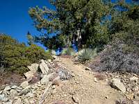
![Looking at Bump on South Ridge to Iron Mtn.#1]() One of the bumps on Iron's ridge route
One of the bumps on Iron's ridge route The terrain is exposed, alternating with a few shaded sections. Hordes of yucca and buckthorn plants are poised to pierce your limbs. Add demoralizing descents knowing that you need a net gain of 6,600 feet to accomplish trailhead to summit. Top it all off with the searing glute/leg muscle burn and lung-busting effort required to make progress up extremely steep sections of sliding dirt.
![Tree Trunk Straddling Brush]() Tree trunk straddling brush along the route
Tree trunk straddling brush along the route![Iron Mtn.#1 South Ridge Route]() Ascending to a resting place along the ridge
Ascending to a resting place along the ridge
But you persevere knowing that it could be worse. Personally, I’m thinking this is "a walk in the park” compared with ascending Big Iron from the other direction, over the San Antonio Ridge from Mt. Baldy. My second ascent of Iron was done by this route. I recall it was a 13-hour day from Manker Flat to Baldy and West Baldy, then over the San Antonio Ridge to Big Iron, finishing at Heaton Flat. But that thought in itself didn’t really ease the pain.
You tend to “acclimatize” your mind for each particular outing. Today, my mind was acclimatized only for Heaton Flat-to-summit and back. Once at Iron’s summit today, the thought of continuing on to traverse the San Antonio Ridge to Mt. Baldy and down to Manker Flat, was, frankly, abhorrent.
During the last vicious mile, my legs were throbbing with lactate burn. I reminded myself that running a 5K race and climbing Occidental Peak yesterday took a lot of freshness from my legs today. Ah well, the excuses are never-ending as to why you’re suffering so much (“Haven’t worked out the past couple of weeks” “Only got 4 hours sleep last night” etc., etc.).
As I said, four in our group today did not make the summit. Three turned back a few minutes into the last mile. The fourth lost the use trail about a ½ mile from the summit and thrashed through the brush until encountered by the group descending from the top. At that point, she opted not to try to make the summit on her own.
The Punishing Descent
Like many mountains, this one does not confine the suffering to the ascent. The ridge’s extremely steep sections sweeping down on expanses of loose dirt, coupled with the sharp yucca and other brush choking the route, explain why, for most people, this is the least fun part of the hike. Losing your balance on the shifting dirt and falling is par for the course. I took two solid falls into brush that left both of my arms riddled with long, jagged scratches. The falling “competition” was won by someone who fell off her feet five times on the descent.
My toes suffer on descents. I’ve tried everything to avoid sore toes, but it’s a fact of life for me. At one point, my quads started to cramp up. Not enough salt intake I figured. I fixed that by downing some almonds. The cramping stopped.
Finally, keep in mind that it’s not all descent. There is 600 feet of gain on the return.
A Moonlight Finish
Everyone was glad to reach Allison Saddle because the rest of the way back is pretty much regular trail. About 2 ½ miles from the trailhead, it got dark. But with the darkness, up popped a beautiful full moon. This put a nice exclamation point on the day’s outing.
Parting Thoughts
Probably like most people, my memory filter allows the more painful memories of a hard outing to rapidly fall off the radar screen and elevates the feel-good memories to high visibility. That’s why I guess I’m not done with Iron even yet. The lure of another visit is out there. After all, I’ve not done it in the direction from Iron to Baldy. And how about the challenge of doing the hike on consecutive days? Imagine, 14,400 feet of gain and 28 miles in one week-end!
I’d probably better lie down until these thoughts pass.


Comments
Post a Comment