Another Iron Challenge
Looking to step up the challenge of the regular south ridge route from Heaton Flat to Iron Mountain #1, and even the roller coaster endurance ride of the east route along the San Antonio Ridge from Mt. Baldy, I joined a group of 5 Sierra Peaks Section members to attempt the seldom climbed north ridge of Iron. It was plain from the abundant droppings on this route that it is a preferred route of the Bighorn Sheep which roam this area.
Rather than knowingly step into a death march by attempting this outing in one day, we opted to do a planned “bivouac” at the base of our route and summit the next day. Knowing that we were facing an extremely steep 4,000 foot ascent to the summit, and that we would have to carry all our water for the entire climbing day once we left our river campsite, our day packs would have to be as light as possible. This meant no tents or sleeping bags.
Along the San Gabriel River East Fork to Fish Fork
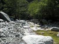
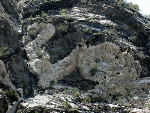
On Saturday, our group [Asher Waxman (amuirman, SP)(leader), Erik Siering (co-leader), Kathy Rich, Rudy Fleck, David Hankins and me] left from the Heaton Flat Trailhead headed up the East Fork of the San Gabriel River. The East Fork actually travels north and south in this area. Despite the very dry year for southern California, there was a decent flow of water in the river in most places, enough to make most of the crossings wet ones. The route along the East Fork is partly trail moving up and down above the riverbed but requiring lots of crossings. A little southwest of where Allison Gulch connects with the East Fork, nature as artist is reflected in the magnificent Swan Rock on the west side of the river.
![East Fork San Gabriel River]() Another section of the East Fork San Gabriel River
Another section of the East Fork San Gabriel River ![East Fork San Gabriel River]() East Fork San Gabriel River 5/19/07
East Fork San Gabriel River 5/19/07![Swan Rock, East Fork of San Gabriel River]() The landmark Swan Rock on west side of East Fork
The landmark Swan Rock on west side of East Fork
In 4.5 miles, we came to the incongruent structure known as the “Bridge to Nowhere.” This bridge appears out of nowhere and goes nowhere except for spanning the river. It is a popular spot for bungee jumpers.
![Bungee Jumper Hurtling Toward San Gabriel River]() Bungee jumper hurtling toward San Gabriel River, 5/19/07
Bungee jumper hurtling toward San Gabriel River, 5/19/07![Bridge to Nowhere Spanning East Fork of San Gabriel River]() Bridge to Nowhere occupied by bungee jumpers, 5/19/07
Bridge to Nowhere occupied by bungee jumpers, 5/19/07
After moving past the bridge, we got into a section of the East Fork known, for obvious reasons, as “The Narrows.” From the floor of The Narrows at 2,800 feet, to the top of Big Iron, 8,007 feet, the rise is 5,200 feet in 1.75 miles. Plainly, the East Fork is one deep gorge!
Fish Fork
After several miles, we came to the junction of the East Fork with Fish Fork. Up to this point, we had seen a few gold panners along the way, but they disappeared after we reached Fish Fork. We headed up Fish Fork first going easterly and then took a branch of Fish Fork going south. Travel up Fish Fork was pretty much all stream-bed hiking over boulders, logs and deadfall.
Riverside Campsite
About 8-9 miles from the trailhead, we arrived at our destination along the river. We established our campsite near what we thought was the gully that would take us to the north ridge. Pickings were slim for individual sleeping sites, but we all managed to find level spots and clear off enough rock to lay our ground cloths. It was truly a pleasant, bug-free evening with mild temperatures and good company. The feeling of remoteness was uplifting. To top it off, the night sky featured a crescent moon with Venus seemingly clinging to the underside of its celestial sister.
My ground cloth consisted of two 30-gallon garbage bags duct-taped together. I put on a fleece for warmth and threw an emergency space blanket over me for cover. I can’t say that I was toasty, but the slight chill that I felt throughout the night was tolerable and I slept a good part of the night.
4,000 Foot Ascent from the River
After a 5 a.m. wake-up, we had cold breakfasts and filled our water bottles. I carried six liters and used five during the day. Our route from river bottom to summit would be 2 to 2.5 miles with 4,000 feet of gain.
Wrong Gully
The gully we started up to gain the north ridge was a brushy beast. From the outset, we did a lot of clawing and scraping to get through vegetation that included volumes of buckthorn and other prickly bushes (what a day to forget protective gloves!).
![Starting up Gully to N. Ridge Iron Mtn.#1]() Starting up gully to north ridge at first light May 20, 2007
Starting up gully to north ridge at first light May 20, 2007
At some point early on our way up, we determined that
we had started up the wrong gully. The proper gully, which we could see over to our right, was downstream of the one we were in. The prospect of having to descend and pick up the correct gully was too horrible to contemplate. But our topo indicated that we should be able to get to our ridge from the gully we were in and so we persevered.
North Ridge
After over 2,000 feet of gully, we gained the north ridge. The ridge starts at an elevation of approximately 6,000 feet. At this point, we lost sight of 2 members of our party. Half an hour went by and still we couldn’t see them or received a response to our shouts. What if they had somehow gone off route, come to an impasse, or one of them got hurt? We nervously joked about an epic. At last, they came into view. Relief!
![Looking Down Gully to Fish Fork River]() Looking down our gully ascent route
Looking down our gully ascent route
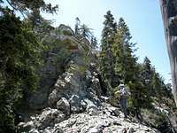
We started up the last 2,000 feet on the ridge. Like the gully we had come up, the north ridge is relentlessly steep. There is lots of scree to impede a steady cadence and an abundance of deadfall to maneuver over, around, or under. When we could, we scrambled over rock. However, being typical San Gabriel Mountain crumbly rock, the 3d class sections of the route were not all that enjoyable.
![North Ridge, Iron Mtn.#1]() A typical segment on the north ridge route
A typical segment on the north ridge route
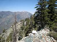
But the views were certainly outstanding, particularly Mt. Baldy connecting to Big Iron by the San Antonio Ridge and Mt. Baden-Powell with its sweeping south ridge dropping 2,000 feet to Ross Mountain.
![Ross Mtn. and Mt. Baden-Powell]() Mt. Baden-Powell (center back)and Ross Mtn. (just left of tree below top ridgeline)
Mt. Baden-Powell (center back)and Ross Mtn. (just left of tree below top ridgeline)
Did I mention that this route is committing? I would not want to descend it and can only imagine a downclimb to be a very intense experience. If you did retreat, you would still have the 8 or 9 miles back out along the river to the trailhead. You simply have to get to the top once you embark on this route.
Getting to the top became easier said than done for one of our party. About a third of the way up the route, he began feeling ill and out of gas. One leader stayed back with him.
![North Ridge of Iron Mtn#1]() Looking down at north ridge from near Iron's summit
Looking down at north ridge from near Iron's summit![North Ridge of Iron Mtn.#1]() A very narrow section of Iron's north ridge
A very narrow section of Iron's north ridgeSummit and Descent
This route is a hell of a climb. I recall the great relief when we gained an overlook at about 7,750 feet and saw Big Iron’s summit to our left less than a quarter mile away. Hooray! Four of us had reached the summit by noon, but the two in back didn’t top out until about 2 p.m.
![Summit of Iron Mtn.#1 from North Ridge]() Summit of Iron #1 from north ridge, May 20, 2007
Summit of Iron #1 from north ridge, May 20, 2007
We were grateful that the temperatures did not get much above the high 70’s. This was my 6th ascent of Big Iron, including once from Baldy along the San Antonio Ridge. But at the top, I didn’t relish the prospect of descending the south ridge with its 6,600 feet of loss and 600 feet of gain.
The 7+ mile descent didn’t disappoint my expectations of a less than enjoyable experience. The front of my toes and bottom of my feet became very tender ( a common occurrence for me on steep descents) and this slowed my pace more than my increasing fatigue. Reaching Allison Saddle was a great relief because you know the steepest part of the descent is done and pretty soon you’re on regular trail. This mental “pick-up” only lasted a short while because, at this point, I was past feeling just pooped and was approaching great discomfort.
I can’t remember ever being thankful to catch the scent of a smelly outhouse like the one at the bottom of Heaton Trail, but on this occasion I was. I arrived back at the trailhead about 5 p.m.
Two of our group had waited at the top for the last two to summit before starting down. The last two did not get back to the trailhead until just before midnight. A very long day indeed.
Impressions: The Toughest Route So Far
So, was the gully/north ridge harder than the trail/south ridge and San Antonio Ridge route from Baldy? Emphatically, yes. And there would clearly be no comparison if you tried to do the north ridge route in one day, as the other two are normally done.
Can the Big Iron ante still be upped? Very possibly. Allison Gulch to the summit from Allison Mine is an unknown, at least to me. And I have heard that there is also a west ridge route. So Big Iron is situated to draw those that want a challenge from any direction. Literally and figuratively, it is a magnetic mountain.


Comments
Post a Comment