Account of Events
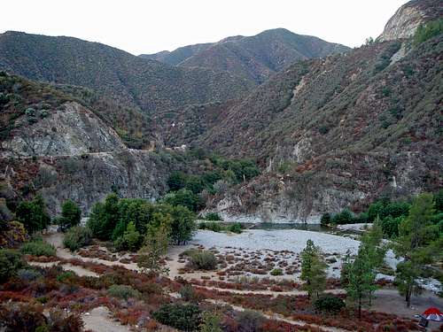
![East Fork Trailhead]()
All the hikes in the past weeks, some of which were pretty tough and long, e.g. Twin Peaks from Buckhorn, Mount Yale from Sierra Madre at about 100 degrees, 3Ts from Icehouse Canyon and back, seemed to have been a preparation – although I was unaware of that at the time – for one of the toughest hike I’ve done in recent years. Hiking 15 plus miles, ascending steep slopes at scorching temperatures, covering 5,000 plus feet elevation, eventually culminated in standing at the East Fork Trailhead on September 20, 2008 at 7am, anxiously waiting to climb 7,000 vertical feet to the top of Iron Mountain in the Sheep Mountain Wilderness of the San Gabriel Mountains. Having read dozens of trip reports and route description on various internet sites I was aware of the mountain’s attributes: “toughest day-hike in the San Gabriels”, “mother of all hikes”, and many more. I knew that stats: more than 14,000 feet elevation gain and loss in about 14 miles in and out; threatening yuccas and buckthorn bushes on steep slopes with loose rocks. I felt ready though.
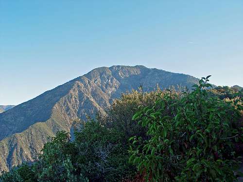
![Iron Mountain from Heaton Flat Trail]()
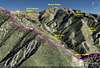
After waiting for the other members of our hiking party we started at around 7:15am, 6 liters of water and Gatorade and some snacks in my backpack. The air was still chilly, the sun illuminating the mountains a few hundred feet above us. The hike started slowly, less than half a mile with no elevation gain on a road along the East Fork of the San Gabriel River. I was surprised of how many people were camping here along the waters. I learned some hours later that many of those folks were actually sieving the waters for gold. Relics from a bygone era, I thought. But everybody seemed content. After about half a mile the Heaton Flat trail leads east from the road still covered in shade up a canyon. The start of the trail is marked by a post (~2,020 feet), which mentions 5 miles to the Coldwater saddle. I was surprised since I never heard that description before, but I figured it’s probably the same as Allison saddle (or Heaton saddle). After a little bit more than a mile and 1,000 feet elevation gain we reached a small saddle (~3,040 feet) overlooking the Cattle Canyon leading east and the Coldwater Canyon switching back north. From this point on we were bathed in sunlight. The trail now turned in northerly direction and we were able to keep a steady and moderate pace. Ever aware of what is yet to come I felt great; my confidence was growing by the mile that I will summit. After another mile and almost 1,000 feet elevation gain we reached a little bump on the ridge, called Bonita Peak (3,970 feet). Soon after, we entered the Sheep Mountain Wilderness. With our destination, Iron Mountain, always in our sight to the north, we kept moving. Mostly along the ridge, sometimes shortly below the ridgeline to the west, over several smaller bumps we reached our first real resting place, Allison Saddle (~4,560 feet). From Bonita Peak the saddle is about 1.6 miles away with 1,000 feet elevation gain and 440 feet elevation loss. Knowing that we will be very tired on our way back I was not thrilled by the thought to ascend all these little bumps on the ridge. We felt great; from the trailhead to the saddle in less than 2.5 hours. Overall we covered about 4.2 miles and 3,200 feet elevation gain with 670 feet elevation loss up to this point (average grade: ~20%). I was aware that this part was the easy one and from now on the real Iron Mountain will show its face. I stashed 2 liters of water on the saddle to lighten the load. I was ready to tackle the mountain.
![Uphill fun...]()
From the saddle the trail merciless started to climb the first 700 feet in less than half a mile with an average grade of almost 40%. As if the mountain wanted to let the hikers know that from now on it will be serious. Even more worrisome were the multitude of yuccas and buckthorn bushes impeding the use trail from both sides. Having neglected the universal recommendations to wear long sleeves and pants I was sure at this point that I will pay the price. The trail now follows mostly the ridgeline with marvelous views down east to the Coldwater Canyon and down west to the Allison Gulch. Mount Baldy with the Bighorn Ridge leading south commands the views to the east/northeast. Mount Baden-Powell with the southwest ridge leading to Ross Mountain dominates the views to the west. After several very steep portions over loose rocks and sand I eventually reached the summit of Iron Mountain at around 11:30am. It was a relentless uphill from the Allison saddle with only very few less steep portions; about 3,550 feet elevation gain with 150 feet elevation loss in ~2.5 miles, which averages to about a 30% incline. From the trailhead we climbed about 6,750 feet with 800 feet elevation loss in 6.7 miles. The views from the summit were stunning all around: Peaks of the Cucamonga Wilderness, Mount Baldy, Dawson Peak, Pine Mountain, Mount Baden-Powell, Throop Peak, Burnham Peak, Mount Hawkins, South Mount Hawkins, Ross Mountain, Rattlesnake Peak, and many more. We rested about 45 minutes soaking in the beauty of the San Gabriel Mountains and forging even more challenging hikes, like the Iron Mountain – Baldy traverse via the San Antonio Ridge. Knowing that that will be the story of another day, we decided to return the way we came.
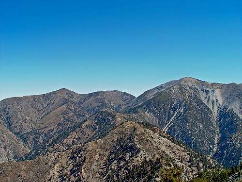
![Mount Baldy and San Antonio Ridge from Iron Mountain]()
For me usually the way back down from a mountain is somewhat an anti-climax, a necessary but not too exciting part of the hike. Let me tell you; the descent from Iron Mountain is everything but an anti-climax. In retrospect, sitting in front of my laptop, I now realize that descending the first 3,500 feet from the summit of Iron Mountain are probably the reason why this peak is considered as one if not the toughest day hike in the San Gabriels; very steep slopes with loose rocks and sand and the ever-present danger to slide or fall into one of the yuccas or buckthorn bushes that grow on both sides of the trail. For me it was extremely tiring to carefully go down step by step for more than 3,500 feet trying to avoid the piercing leaves and thorns. But let me tell you: you will get poked many times, you will get scratched, and there is a likelihood that you will bleed (minor). Besides the physical preparedness for this mountain, you have to be mentally prepared as well to deal with some sort of pain. I found myself many times in the situation that I jumped to the other side of the trail trying to avoid getting poked by a yucca only to land in another yucca on the other side. You can wear long pants and long-sleeved shirts, but be assured that the pointy yucca leaves will pierce right through. Don’t get me wrong; I was not surprised by that. It’s just something you have to be prepared to endure. Eventually, after grueling 3,500 feet of descent we reached the Allison saddle happy to find our stashed water reserves. After spending most of my energy, I knew I had to hike more than 4 miles with 3,200 feet of elevation loss and about 600 feet of elevation gain back to the trailhead. Eventually and with great sense of accomplishment I reached the car at around 4:30pm, about 9 hours after I started.
The final stat was: 13.45 miles, 7,530 feet elevation gain with an average grade of 22%. From our group 14 out of 15 people made the summit. The only one who did not summit had planned to go only to the saddle because of some knee issues. Being very proud of ourselves we relaxed for a bit on the parking lot before we all went our ways knowing that another challenge is looming ahead…
Disclaimer: The track was recorded on a Garmin GPSmap 60CSx with coordinate savings every 30 seconds. Mileage- and elevation readings were calculated after importing the gpx file into National Geographic’s Topo 4.0 software. Below are some Google Earth Renditions of the described hike.


Comments
Post a Comment