A road trip out East
My wife and I decided to spend our 6-year anniversary by taking a week driving from Indianapolis to the Northeast. My wife loves it up there, and we had never been to Vermont or New Hampshire, so needless to say, I immediately began drooling over the thought of hiking Mount Washington.
We began our trip by driving to Penn State University and walking around, then spending a wonderful evening in picturesque Scranton, PA. The next morning, we drove to High Point, NJ, and walked to the top from the parking lot. It was extremely foggy, so there were absolutely no views (this may have been a good thing...it is New Jersey, right?). When I asked the girl inside the monument if she knew where the survey marker was, she gave me a look of "How big a dork are you?" that I haven't seen since 7th grade. Ok, since Thursday, but you understand.
We then headed straight for the Rhode Island high point, which as I understand, was recently granted a trail and isn't technically trespassing anymore. I don't quite understand why there were 3 survey markers there, but another one got checked off the list.
We took detours through Brown University in RI, visited Rockport, Mass, Gloucester, Mass, etc. We ate lobster and loved every second of our time in Massachusetts.
What do you mean a hurricane?!
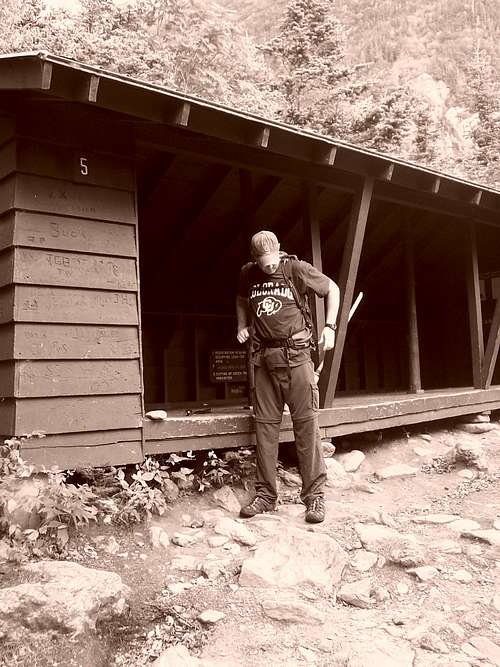
We eventually made our way to North Conway, NH (which I've found to be a slightly more upscale version of Gatlinburg, TN. Those of you familiar with Gatlinburg know this is not necessarily a good thing.) We visited the Mt Washington ranger station at Pinkham Notch the evening before our attempt, and were told that Hurricane Ike (yes, the hurricane that hit TEXAS!) was passing through over the evening, but with any luck, would clear by the time we got up there the next day. The next morning came, and we arrived back at Pinkham Notch around 6:30am. The rangers told us in no uncertain terms that we should not attempt it that day, and that we would not make it to the top, as the winds were SUSTAINED 60-80mph, with gusts well over 100. WOW! We told them we would go to the Tuckerman bowl, and probably turn back at that point (my summit fever was already starting at that point).
We signed in at the register and started our trip up around 7 or 7:30am. I should mention at this point that my wife enjoys the outdoors, but doesn't necessarily enjoy suffering in the outdoors. Our hike up to the bowl was superb. The weather was warm, sunny, a truly beautiful New England morning.
![Mount Washington]() Times were good at this point.
Times were good at this point.
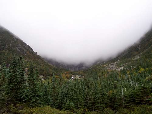
We hit the bowl, and we could see the ominous front higher up along the ridge.
![Mount Washington]() Ummm....not a good sign
Ummm....not a good sign
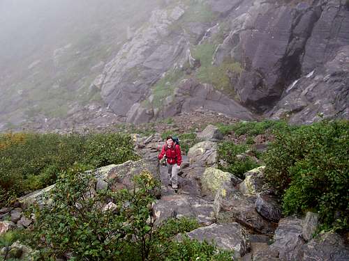
Spirits were still very high up the headwall. This would be fleeting, and the last time my wife would smile that day.
![Tuckerman Ravine Bowl]() Her last smile of the day, right here.
Her last smile of the day, right here.
As we made our way up the headwall, the temperatures began to drop drastically, and an occasional gust would slam into us. As we went up the steepest point of the headwall, it was as calm and quiet as it could be. As I got to the top of the headwall and got closer to the ridge, the wind and rain were absolutely pounding me. I often had to keep all four appendages on the rocks in order to keep from getting blown over. I decided to go as far as I could before I hit a point where I felt my wife would be in danger. I went as far as the Tuckerman crossing and decided to call it quits. Mount Washington had blasted me with everything she had, and I didn't feel safe going any higher. At this point, with the cold, and the wet, and the wind, and most importantly the rocky terrain, my wife's mood changed suddenly. She no longer wanted to do this. Rather than head back down the Tuckerman, we thought the Lion Head route would offer more manageable terrain (oops).
My wife is an extremely slow hiker to begin with. On wet rock, every step of hers must be carefully placed, and no weight is transferred until both feet are solidly placed. I am opposite in that I'm essentially a mountain goat. My size 14s grab the rock and hold it, period. Hers, not so much. As such, going down was extremely tough on the wife. Her knees were hurting, she was cold, wet, and exhausted (we ARE from Indiana, you know).
We hit the low point of the day when I looked back, saw my wife further up the route, watched her take a step down, saw her wrench her knee a tiny, tiny bit, and then I saw the tears. She quietly began to sob, then a snot trail began forming from her nose. The wind then got hold of said snot trail, and it eventually grew to roughly 3 feet long! The tears and Guinness World Record snot trail were too much for me. I felt so bad for her, but speaking to her was not what she wanted at this point.
Some of her best quotes from our trip include:
1. I just want to get off this ****ing mountain!!
2. (When I pressed her to move faster) "I'm not getting injured for this ****!
3. (Near the bottom, when I told her "Hey, you definitely earned your dinner today"), "When we get home, I'm going on Ebay and selling all this hiking **** and taking that money and buying myself a new purse".
4. We found a Dunkin' Donuts after we left, and she told the employee, "Give me the biggest coffee you have ever made".
The entire trip took NINE hours due to my wife's slow movement, but she was a true trooper, and while we didn't make the summit, we had an amazing time (as well as some long-lasting knee damage. Bonus!) We drove to Stowe,VT that night, ate a monstrous pizza, then planned our hike up Mansfield the next day.
The day after hurricanes are always great.
For Mount Mansfield, we just drove up the $23 toll road and hiked the 3 miles roundtrip to the top. It was absolutely magical. The clouds broke when we got to the top, and we were granted incredible views.
![Mount Mansfield in September]() The views were incredible!
The views were incredible!
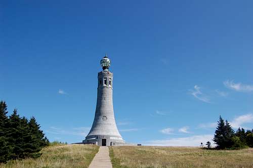
We left Stowe and stopped in Woodstock, VT before staying just north of North Adams, MA, for my attempt at Mount Greylock the next day.
![Summit of Mount Greylock]() Mount Greylock
Mount Greylock
My wife decided to visit North Adams while I hiked Greylock, and I made incredible time going up without her. The hike was fairly uneventful, other than the fact that all that pizza I ate eventually (due to the natural digestive process) had to make its way back out. I set a personal record on my deposit off the Greylock trail. (seriously, there's styrofoam in landfills that will break down faster than my "product") My apologies to the Commonwealth of Massachusetts and its people.
We snacked on some Cabot Sharp cheese purchased in Stowe and made our way to Mt. Frissell and were able to tackle that highpoint right before sundown, with our plan to drive to Gettysburg the next day, and then hit Mount Davis in PA the next day.
What a great trip
Our trip was a very memorable experience. We visited beautiful countryside in NH and VT, and I cannot wait to make a return trip to Mount Washington to try it again. I don't think my wife will join me, she'll enjoy the sights and sounds of North Conway next time. I also got to add 6 more highpoints, and a nice story of failure on Washington. That brings my total to 14, with my goal to hit 9 more this year. Thanks to all those that read this, I realize I can be a bit wordy.


Comments
Post a Comment