NOTE:Some of this Trip Report was written while on the trip and most of it was written after I had finished the trip. Therefore it switches from present tense in the first few paragraphs to past tense. I did not take enough time to write while on the trip, so the majority I had to finish once I was home.
April 11, 2008
Mt Mitchell, North Carolina (6,684 ft)
A.M. - Sitting on the slopes of Mt Mitchell and enjoying a later morning breakfast. Last night I got the rental car and left home around 4:30pm to begin the drive. I stopped only once, in southern Virginia, to fill up on gas. By shortly after midnight I had arrived where I wanted to be, at the Black Mountain Campground. Sleeping across the backseat of the car last night was not comfortable at all. There was only about 4 feet of space and I am 5’11”! Some uncomfortable, restless sleeping ensued, but I awoke this morning feeling more tired and somewhat sick with a cold then when I went to bed. I wonder if sleeping in the front with the seat tilted back would be more comfortable.
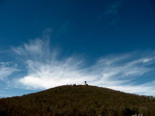
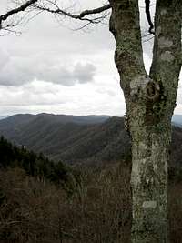
![Mt Craig]() View of Black Mountain Range
View of Black Mountain Range
After getting around this morning I began to try to find the trailhead. I got some help from a mountain biker, who was rather friendly. Now as I climb Mt Mitchell, I have not seen one person along the trail yet, on this warm and gorgeous day. I don’t know how far I have come so far, because I don’t have a map, but the trail length is 5.6 miles. I am sure I have gone around half of that. Now to the top of the highest peak in the east.
P.M. – I finished climbing Mt Mitchell by 3:30 this afternoon. It seemed a long, trudging, tiring haul to the top. And then once I got there the trails to the summit were closed due to a reconstruction of the summit tower. So, I ducked under the gate and made my way to the top. It was pretty hazy, with some peaks to the west enshrouded by clouds. The peaks to the north, Craig, Tom, and others, were the best to view. They were not that far away, so I wasn’t looking at them through the haze. I sat at the top, ate lunch, and called mom.
Then I began the descent down. My legs were pretty weary, but I continued onward, taking a few short breaks to get water and rest the legs. I ran into a few people coming up as I was going down and chatted with them for a few minutes. In all honesty, I did not have a lot of fun going up and down Mt Mitchell. I think because I have had a sore throat that is hoarse and the lack of sleep lately, with the very uncomfortable sleep last night, I was just not feeling perky. I was back at the car around 3:30 and took a few minutes to organize and get ready for the drive.
![Black Mountain Range]() Clouds and the Black Mountains
Clouds and the Black Mountains
The couple hour drive to western South Carolina was refreshing and relaxing. I took an ibuprofen, as well, and now I am feeling much better. I had to get organized again and brought my tent just up off the road on the Foothills Trail that will lead to the top of Sassafras Mountain. I called home and called my brother Brad to let them know things were going as planned. Then I set up, ate dinner, and now I need to get some rest for the night. It also started raining while I was in my tent and is raining quite hard right now. I hope it ends during the night as it cools down so that tomorrow will not be wet.
April 12, 2008
Sassafras Mountain, South Carolina (3,560 ft)
I don’t know how long it continued to rain last night, but at least for a while because I fell asleep. I awoke at 1:00 am and 5:00 am, but had to fall back asleep each time since it was still dark. About 6:45 am I got up and got things around. It was foggy and humid this morning. I made some breakfast then got hiking. I was quite amazed at the rock outcrops, steepness, and overall uphill climb to the top of Sassafras. I was not expecting it to be like this; more hill-like is what I was expecting.
As I made the final approach some thunder rolled in the distance. The sky got dark as well, but it only sprinkled a few drops. The summit is rather flat-topped but it is marked. The state border sign is only a few hundred feet back on the trail. This is highpoint #15 for me. Right now it is breezy and very cloudy, but the fog that was originally here has lifted. I have felt much better this morning then I did yesterday. I was actually able to get some decent sleep last night. And the sore throat and cold has gone away, seemingly, although I still am coughing up junk. I reached the summit shortly before 9:00 am. Now I have to try to bag Brasstown Bald in Georgia later today.
![Georgia Mountains]() A view to the south from Brasstown Bald
A view to the south from Brasstown Bald
Well, I’m in Memphis now at the hotel, but I have had a whirlwind of a few days. I descended Sassafras Mountain with a few rain drops and some thunder still in the distance. At the bottom I packed up my stuff and put it into the car and then ran into a couple of friendly folks who were going to do a day hike on the Foothills Trail. They told me the entire length of the trail was 76 miles. Then I hopped in the car and took off for Georgia. I took some supposedly main roads that twisted and turned through the mountains. The speed limit barely went over 35 mph. There were some good overlooks along the way, too. I finally pulled into Clayton, GA, where I filled up on gas and drank a soda. Then I headed up over the next mountain ridge.
Along the way up the ridge I saw a sign that said ‘Appalachian Trail’ and after rounding the bend I saw two guys with their thumbs out. I quickly pulled into the parking lot and asked the guys where they were going. They told me Hiawassee, which was pretty much along my route anyway. They stuffed their packs in my trunk and we started down the ridge toward Hiawassee. I learned that the guys were from Jamestown, NY, and were both working for the other’s dad, so they saved up money to do this trip. They had been on the trail for seven days and were hoping to make it to Maine in September. The guy who sat in my front seat was named Owen. The guy with orange hair and beard in the back, I don’t remember his name. I shared with them my experience with the Long Trail and they seemed like really cool guys. They also looked like they knew what they were doing, with small, light packs and the appropriate attire. Though they were complaining about knee pains already. Then we arrived in Hiawassee and I left them off at the Mull’s Motel.
Then I continued down the road toward Brasstown Bald, Georgia’s highest peak. I arrived at Jack’s Gap at about 2:00 pm, later then I had wanted to get there, but with still plenty of time to make the ascent. I found the trailhead, put my boots on, got my pack, and began the hike. I moved quickly at first, wanting to make up some time. The trail climbed quickly away from the road and switch-backed up the mountain. I really did not stop for the first hour or so, as I climbed up to a small knoll before Brasstown. I stopped to get a drink, eat a snack, and read my Bible there, while getting a somewhat obstructed view of Brasstown Bald and the surrounding mountain terrain. I picked up my pack and continued on a short downhill hike to the upper trailhead at an enormous parking lot sitting on the crux of the mountain. A few people were here and there, but it was rather obnoxious to have a giant sheet of pavement on such a pristine mountain. And the top would only get worse.
![Brasstown Bald]() Brasstown Bald from the giant parking lot
Brasstown Bald from the giant parking lot
I took a few pictures of the surrounding mountains and clambered across the blacktop. I was appalled to find that there was a 6/10 of a mile, paved trail that wound the rest of the way to the top of the mountain. The slow, old, young, large, and otherwise normal people were trying to climb this last knoll that there cars were not allowed up. It was not the people that annoyed me, but the thought of taking a beautiful mountain and paving half of it and turning it into a tourist spectrum that bothers me. I heard some complaints as I passed by the people about the hard trail that they were taking to the top. I was speechless and could hardly open my mouth to the people on this mountain. I don’t know if it was the fact that I was the only one up there at the time to have walked further than the parking lot 6/10 of a mile down or feeling full of myself, knowing that I had ‘actually’ climbed the mountain. My pride; how worthless. But I spent some time taking in the views and seeing what the information center offered. The 360 degree views from the platform were magnificent, however I would have taken a tree-filled summit over the tourist spectacle.
Then I began to quickly descend after taking some time to locate the ‘actual’ highpoint, which ended fruitlessly. I went to the parking lot, marched acrossed it and entered my trail to take to my car. I had to battle a little uphill to the knoll before Brasstown Bald, where I again rested and got refilled on water and food. I made the final, uneventful descent with many thoughts and aloneness, passing two guys and a dog. They were the only people I ever saw hiking up the mountain and not driving virtually to the top. Once back to the rental car I began driving another leg, bypassing Atlanta, entering Alabama, and the Central Time Zone, and mentally preparing for a new highpoint.
April 13, 2008
Cheaha Mountain, Alabama (2,407 ft)
I arrived at the hotel in Oxford, AL about 20 minutes before Brad, my brother, would arrive. After checking in and getting organized, he arrived and I took my first shower in a few days. We headed out to grab some dinner at a place called ‘Struts’, where I ate a burger and he got some wings. We caught up about life and just shared about recent events we had been going through. Then we went back to the hotel and watched television before finally falling asleep. How incredibly trivial and pointless television seems when it is not a part of your daily routine.
![Alabama Mountains]() Cheaha from the viewing area on AL-281
Cheaha from the viewing area on AL-281
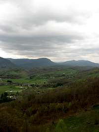
We got up at seven and ate breakfast at the hotel. From there we began the drive to the trailhead. After turning on AL-281, I began to realize that this wasn’t the stereotypical land formations of Alabama. We drove up a twisty-windy road along a mountain ridge and pulled over in a viewing area of Cheaha Mountain. This area seemed an anomaly within the state, but I think it’s safer to say that most don’t know or understand that Alabama does have the southern Appalachian Mountains stretching into the eastern part of the state. We then continued to drive right up over a saddle of the mountain and down the other side to Cheaha Lake. Down around the lake spring was prevalent everywhere.
We began to hike up the Lake Trail, which followed the stream that fed the lake, up the mountain. Flowers were out, trees were flowering, and leaves were popping out. The trail slowly got steeper as it followed the gorgeous stream. It soon climbed up over some rock outcrops and came to an amazing view of the Alabama countryside. A rock cliff ledge, with a few stunted trees, and a dropping waterfall, all overlooking a light and brilliant green of the surrounding land with a stretching mountain chain is what stood at the rock gardens. We spent quite some time taking in the view and snapping numerous pictures with our digital cameras.
Then we continued on up the trail where it quickly met a road. From there to the actual summit we had to walk around some roads, through cabins, campgrounds, and picnic areas to reach the highest point in Alabama. The woods that remained and the views that could be seen were gorgeous, even though much of the top of the mountain was developed. We passed flowering trees and chattering squirrels, along with a few campers and reached the summit tower. We were able to go to the top of the overlook tower, which didn’t have as nice as the views from the rock gardens, and walk around to see the couple of summit markers.
![The Rock Gardens]() View from the 'Rock Gardens'
View from the 'Rock Gardens'
We then descended down to the summit restaurant, where we sat and ate our lunch on their wide deck, which overlooks the lake. We asked a park employee where the store was located and decided to go to it on our drive back over the shoulder. Then we began the decent. My brother and I did not stop on the way down to take in the views, but instead spent the time talking and climbing down off the mountain. Since the trail was only a mile long, we descended rather quickly. At my brother’s car we hopped in and drove up to the store.
At the store we picked up a couple of root beers and talked to a very interesting guy, who was born and raised near Burlington, VT. Since Brad and I each spent some summers in Burlington, we were able to talk to this guy for a while and relate to him pretty easily. He was probably in his 60’s and his name was “Pop.” Pop loved to tell stories and he had quite a many to tell us about his younger days in Vermont. After chatting for about a half an hour with Pop, we said goodbye and drove back to the hotel, where my car was sitting.
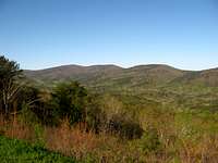
![Alabama Mountain Ridge]() Mountain ridge extending south from Cheaha Mountain
Mountain ridge extending south from Cheaha Mountain
Now it was time to grab the fifth highpoint of my trip and 18th in my life. I said goodbye to Brad and got on the road toward Birmingham. After looping around Birmingham I headed north and eventually northwest across the state of Alabama. Woodall Mountain sits just a few miles across the state border into Mississippi and is only a few miles south of the Tennessee border.
After crossing the border I had followed directions to get to an area where I could supposedly hike up the hill. I printed these directions from the internet (SummitPost, actually). The only problem came when I arrived at the gate. Posted all over the gate were ‘POSTED’ and ‘NO TRESPASSING’ signs. I didn’t want to get in trouble nor did I want to cause any problems, so I decided to drive up to the top, since I knew there was a road to the top. I had to backtrack a little in my car, but within 15 minutes I was on the highest point of the state of Mississippi.
![Mississippi Sunset]() Woodall Mountain during sunset
Woodall Mountain during sunset
Radio towers, power lines, and woods surrounded me. I looked around and noticed there was a power line running down the hill and decided to walk down it a ways since my plan was to hike every one of the highpoints that I was climbing on this trip. The initial descent was fairly steep, going down a washed out four-wheeler trail, but it leveled out and became rolling terrain. I watched a few deer bounce in front of me, saw a cow skull in the woods, and examined a few pretty flowers, but eventually decided to turn around to make the final trip to Memphis.
As I was meandering back up the hill I heard the sound of a four-wheeler and quickly turned to see one pulling up the power line. I continued to walk, hoping that they weren’t intending to talk to me, but it became obvious as they drove close that I was their target. So, I stopped and watched them pull up and a few dogs of theirs ran up to me as well.
On the front of the ATV, driving was a young kid, probably in his teens. Sitting on the back was an older man, who I assumed was the father. They asked me who I was, where I was from, and why I was on the land. They did this in a gentle way and were quite courteous. I replied to their questions, making sure to tell them that I was only visiting the highest point in Mississippi and wanted to take a walk. They knew of the highpoint and pointed out that they had lived in the area their entire life. As a final statement, I told them that I was returning to my car at the top of the hill and heading on to Memphis. Then they drove away as I finished the climb. A run-in with a few Mississippians, but they were very gracious and wanting to make sure that nothing suspicious was going on. Couldn’t blame them for that.
![Pink Flower]() Flowering tree in Cheaha State Park
Flowering tree in Cheaha State ParkApril 19, 2008
Clingman’s Dome, Tennessee (6,643 ft)
After a week in Memphis for work, I was ready to get to the mountains again. After driving across the state of Tennessee I arrived in Sevierville, with the Smokies looming to the east. This was the first time I had ever seen the Smokies. They grew high up over the valleys and foothills of Gatlinburg and the surrounding areas. They were gorgeous.
I checked into my hotel room and grabbed some Mexican for dinner while waiting for my brother and his friend to arrive. After they got lost for a while and got stuck in traffic, they arrived at the hotel. We spent the night preparing for our trip into Great Smoky Mountain National Park the next day and then went to bed. We were ready to visit a place that none of us had visited before. The next morning Grant, my brother’s friend, myself, and my brother loaded into the rental car and began the drive toward Newfound Gap.
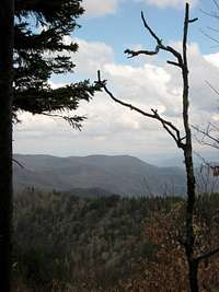
![Great Smoky Mountain National Park]() View from Appalachian Trail
View from Appalachian Trail
At the entrance to the park we found our first of many turkey’s throughout the park. Two big gobblers and two smaller jakes stood in the lawn near to the visitor’s center and paraded around as if no one was watching them. We filled our water bottles at the visitor’s center and then began the steep and windy drive up the mountains. As we neared Newfound Gap the weather got worse. It began to rain, the skies got dark, and the wind picked up. By the time we arrived at Newfound Gap the rain was beating down quite hard and few people were leaving their cars. In a quick flurry, we jumped out of the car, got all our rain gear on, got our stuff together, and began the hike, already wet.
For the first few miles the rains came intermittently and we continued to get wet from the rain and from the puddles. We passed some AT hikers as we climbed, but nothing too exciting occurred. On the top of Mt Collins, another 6,000 foot mountain, we could start to see some clearing in the sky and could see the fog-filled valley’s below. But we continued upward toward the highest summit of Tennessee. When we arrived at the top we had gone a total of 7.9 miles since Newfound Gap. We were feeling fresh, but still damp from the frequent showers. However, we would not be rewarded. The summit was enclosed in a cloud. Mist, cold, and rain hung around us as we sat and ate lunch on the ‘spaceship’ summit tower.
![Appalachian Trail at it s Highest Point]() Clingman's Dome and Appalachian Trail
Clingman's Dome and Appalachian Trail
People came and went, as most were under-dressed and under-prepared for the cold and wet of high mountains, having driven up the road to the near top. Eventually we got cold, after about 20 minutes on top of Tennessee. There was nothing left to do but climb back down the mountain. We had thought maybe we would work our way over to Siler’s Bald, but being 3 miles one way (or 6 miles round trip) out of the way, we decided that was unnecessary. So we began making a descent.
Climbing back down was much more pleasant than coming up. The rains had cleared and we even got some limited views on Mt Collins and elsewhere. We met more AT backpackers, some doing a section-hike, others thru-hiking the trail. I don’t think we met another day-hiker anywhere on the trail. We made exceptional time on the way down, since we were going downhill, but toward the end we all were getting weary. Sixteen miles of hiking in one day is a lot of miles, no matter how much elevation you are doing, because we didn’t have that much.
Once back at Newfound Gap we were surrounded by tourists and people who had stopped their cars on their drive through the mountains, since the day had gotten remarkably better. The clouds still covered the land with light shining through on various mountain ridges in the distance, so we rested and took some pictures of the great view from the gap. My brother, Brad, even had a tourist incorrectly tell him he shouldn’t have his flash on because he didn’t, and then the guy handed him a business card for his camera shop somewhere in California. First, who is going to listen to an arrogant business man who claims to know more about photography, and second, who is going to travel from Tennessee to California for a camera shop? What awful business practices!
After grumbling over the camera man for a few minutes we hopped into the car and headed down the mountains. On the way down we stopped at a gorgeous overlook that viewed back up toward Balsam Point, a smaller knob on the ridge from Mt LeConte, one of the southern sixers.
![Balsam Point]() Spring view of Balsam Point in GSMNP.
Spring view of Balsam Point in GSMNP. The view was beautiful, with the lower elevations in a various array of greens, the higher elevations still bare, the sun shining, but some threatening and lingering gray clouds towering over the higher peaks. This was surely the best views we had in the Smokies.
We continued down to a nearby campground, set up, and then headed into Gatlinburg, to pick up a few supplies. What a rat race of a town! That night we had a campfire, where we roasted hot dogs, marshmallows, and enjoyed feasting after a day of climbing. It was incredible to be able to hang out with these guys, my brother and a new friend, Grant, and relax next to a fire on a pleasant spring night.
April 20, 2008
On Sunday morning we awoke and packed up all our gear to ready for leaving. Since Grant had to be back to Alabama by that afternoon, we didn’t waste much time in the morning. After packing and enjoying a few morsels for breakfast, we decided to see what Caves Cove was all about.
![Cades Cove]() View at Cades Cove
View at Cades Cove
Arriving at the first field, we were struck by the sheer beauty of the area. Lush and green grazing fields for horses and wildlife stretched into higher mountain ridges that were completely bare of any springtime influences opened up to us. We stopped there to enjoy the scenery and to take a few pictures. It seemed heaven-like, especially with deer and turkey around every corner, grazing in the open fields or meandering through the woods. Though the beauty and wildlife would soon become curses.
Since we were on a timeline, needing to be back to the hotel parking lot, where we had left Brad’s car, before 11:00 am, we had little time to spare. However, the cars in front of us, on this one-lane 15 mile road, were not in a hurry, rarely ever driving above 15 mph, even though the speed limit was 25 mph. Since it was all one-lane we could not pass unless the cars in front decided to pull over and let us pass. Yet, no one heeded the large signs that warned of courtesy to allow other to pass, but lines of cars would pile up and we would stop for every animal and creep at all other times. It took us over an hour and a half to get around this loop, the last 3 miles driving recklessly at 40 mph, because all other cars had either pulled over or stopped. Yet our misery was not finished.
![Newfound Gap]() Newfound Gap view in GSMNP
Newfound Gap view in GSMNP
We still had many miles of twisting and turning two-lane roads with heavy traffic to get back to Sevierville. It seemed to take forever, as we got stuck behind mobile campers and stopped at red lights while the tourists began fleeing from the mountains on a Sunday, ready to hit the jobs again Monday morning. Traffic on the main roads out of the Gatlinburg/Pigeon Forge/Sevierville vicinity was backed up for miles, as the lanes going in were relatively free of cars and easy moving. We arrived at the hotel around noon, already an hour late, and still needing to get to the highway. I said goodbye to my brother again and told Grant that I would be in Memphis again in June, since Grant is from the Memphis area. We made plans to hang out there in June.
Black Mountain, Kentucky (4,145 ft)
Then we split ways and I proceeded toward the Interstate, through the heavy traffic. Once on the highway, traffic began moving at a more open and unreserved pace. I made my way up I-40 to I-81 and began setting my eyes for the final highpoint of my trip: Black Mountain in Kentucky.
After crossing into the very southwest corner in Virginia, I made my way around Big Stone Gap, a mining town in the Cumberland Plateau. I missed my exit and proceeded to climb a long hillside to a lookout over the rugged terrain. It was quite gorgeous, with the skies gloomily unpredictable in the spring weather, the mountain sides in all colors of green, with a long, deep-gutted valley far below with farmlands and homesteads throughout.
![Southwest Virginia]() Southwest Virginia near Black Mountain
Southwest Virginia near Black Mountain After spending a few minutes taking in the view, I hopped in my car, turned around, and headed back toward Big Stone Gap and to the road I needed. After getting lost for a few minutes in town I found the right road and proceeded up the road toward Kentucky.
Bend after bend came until I reached the saddle of Black Mountain. In the distance other mountains stood, half torn apart, ravished by the raging effects of mining. I quickly jumped on the trail, though more of a road and very drivable, to get to the top. As I walked up I couldn’t help but think of my home in northern Pennsylvania and how similar this looked. The woods, the smells, the colors all reminded me of home on the Allegheny Plateau. I guess since it is all one large plateau region, stretching from New York State, down into Tennessee, along the western side of the Appalachian Mountains, it must have resembled home.
As I climbed, a minivan made its way down the road/trail, most likely another high pointer. I passed the FAA tower and got to the top. It wasn’t too exciting, with an abandoned fire tower, and many other radio towers prominent on the summit. I stood there for a few minutes, recalling my long-awaited trip that was now mostly a memory. I was tired, dirty, and a long way from home. I was alone and desiring to talk to someone, though no one was near as the sun began to sink on a Sunday evening.
I walked back to my car, parked between two state ‘Welcome’ signs and preceded down the ridge and across the rural terrain to the Interstate. I decided I wanted to get back home sooner than later, so I continued that way. I had taken the next day off from work, assuming I would be driving home that day, but now thought of the possibility of relaxing that day. I drove as the sun set and the skies clouded over and poured down rain. For most of my eight hour drive home it rained. And it rained hard. The rain washed my spirits anew as another trip was gone. I arrived home at 12:30 that night and quickly fell asleep.


Comments
Post a Comment