Conditions: The area received over a foot of fresh snow during the preceding week. Night time temperatures at the Timberline Lodge were just below freezing. Day time temps were in the upper 40's(F). Winds were blowing 30-50 MPH while we were there. The snow was reasonably consolidated and avalanche danger was moderate.
April 8: My friend Dave and I flew in to Portland from Chicago, rented a car and drove to the Timberline Lodge. We arrived just in time to rent snowshoes before the gear shop closed at 5pm. We had a fantastic dinner in the lodge, packed our backpacks, and were asleep by 9pm. The time zone change was in our favor and made our early-to-bed, early-to-rise plan a little easier.
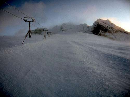
April 9: We awoke at 3am, got dressed and had a light snack for breakfast. The temperature outside was around 20(F) degrees, with ~30 MPH winds. By the time we got bundled up and put on our snowshoes, it was 4am when we hit the trail.
We started up the climber's trail just east of the lodge. However, in the dark with fresh snow, it’s pretty hard to tell where exactly you are. We ended up hiking up one of the ski runs and just followed the compass needle north. About half an hour up the trail, a Snow Cat nearly ran me over. It seemed pretty early to be grooming the slopes. We thought perhaps the driver was grooming a path for us. (What a nice guy!) Later, we discovered that they use the Cat to shuttle climbers up to the hut. (Isn’t that cheating?!) Well anyway, at least we could follow the lights and be sure of a clear path for a while.
We ran into another group of climbers around 5:30am. They looked like they were half frozen, huddling next to a ski lift for wind protection. We stopped briefly to talk and they seemed amazed that we were actually going to continue towards the summit. They seemed young and inexperienced, but they were still low on the mountain and the sun would rise soon. So we didn’t worry about them much. I assume they turned back as we never saw them again.
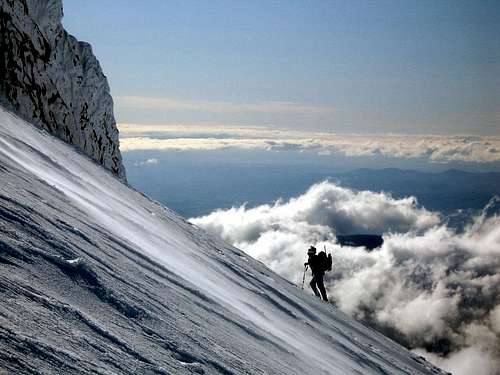
Climbing out of the CloudsClimbing out of the Clouds
It was pretty slow going in the dark, with a steady head wind. We stopped a few times to make some clothing adjustments, or to de-ice our goggles. We reached the Silcox Hut at first light. As we continued up the Palmer Glacier, we broke through the cloud layer at around 8000ft and could finally see the route ahead. There was a team ahead of us and another one behind us (but not the college kids we saw earlier). The route thus far is not very steep. It starts to get a little steeper as you near the Devil’s Kitchen. We stopped for a break there and then continued to the Hogsback just around the bend.
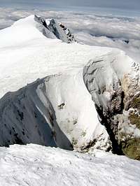
We reached the Hogsback by 10:30am and were treated with an incredibly picturesque view of the snow covered formations inside the crater; Crater Rock, the Hogsback, the Pearly Gates and the breathtaking ice coated crater walls themselves. It’s truly spectacular to see! Once inside the crater we dropped our packs at the base of the Hogsback, swapped our snowshoes for crampons, got out our ice axes, and ascended towards the Pearly Gates. The snow on the Hogsback was 6-8 inches deep and pretty easy to climb. We passed the bergschrund on the right. I actually read that it was open during the weeks before our trip. However, with over a foot of new snow in the past week, the bergschrund is now closed again and we saw people walking over the entire length of it (roped). --> You should obviously take great care in passing the bergschrund, which ever side you decide to take... The route gets a bit steeper in between the Pearly Gates and the snow was harder, but we didn't feel the need to rope up.
Gusty Winds on Mt HoodGusty Winds on Mt Hood
Rime ice formations (Mt Hood)
Ascending the Pearly Gates
Once above the Pearly Gates, it’s a short, easy climb up to the summit rim. The sky was crystal clear, however the wind was now gusting to ~40-50 MPH. We didn’t stay long, but what a great view!
We retrieved our packs and started what we hoped would be a hasty retreat back to the lodge. However, as we descended past the Devil’s Kitchen, we encountered white out conditions at around 10,000ft. It was so thick, we could barely see the snow beneath our feet. In fact, we both took tumbles on several occasions on the way back because we couldn’t see where we were stepping. At one point, we both rolled off a 10ft hill…! Luckily we landed in soft snow. What’s worse is that we couldn’t see any landmarks to tell us if we were on route. Since my GPS batteries had died, our only course was to follow the compass needle due south. After a couple of hours of very slow hiking, the clouds opened up just long enough for us to see that we were about ¼ of a mile west of the chair lift. That was all we needed to get us back on track.
We stopped briefly at the Silcox Hut for a break. When the driver of the Snow Cat offered us a lift back to the lodge, well, we couldn’t refuse. (It's only cheating if you use the Cat going up the mountain...)
We made it back to the lodge by 5pm. I was tired but filled with the deep sense of satisfaction and elation that I only get following a successful summit. And that was the end of a truly fantastic day of climbing.
Thanks! Yes, the crater is magnificant! I don't often climb the same mountain twice, but I have a strong inkling to go back to Mt Hood. Sadly, my climbing partner was killed a few months later while climbing in the Bugaboos. So Mt Hood has a special meaning for me as the last placed we climbed together.
Parents refers to a larger category under which an object falls. For example, theAconcagua mountain page has the 'Aconcagua Group' and the 'Seven Summits' asparents and is a parent itself to many routes, photos, and Trip Reports.


Comments
Post a Comment