To suggest that Gannett Peak is an easy mountain to climb is not giving the peak its deserved respect. Its remoteness adds a significant challenge to the climb, as does the unpredictable weather in the Winds. Some moderately technical climbing is also required to reach the summit.
Gannett Peak, the state highpoint for WY, is located in the heart of the Wind River Range, 16 miles from the nearest trailhead. My partner and I attempted to make this climb as simple as possible, to maximize our chances of success and to have an enjoyable trip. I think we succeeded on all counts.
I tip my hat to the immortals who can climb it in 3 days or less. Our strategy followed a more reasonable pace: a 2-day hike in, 1 rest/acclimatization day, 1 summit day, and a 2-day hike out. That worked out perfectly for me and my climbing partner Tom, who I met on Aconcagua last year. (Aco trip report.)
Crossing the Indian Reservation
Our day started by meeting our Indian guide at 8am in the town of Crowheart, WY. The Cold Springs trailhead offers the shortest access to Gannett Peak. However, it is located on private Indian land and transportation to/from the trailhead must be arranged with the Wind River tribal council. (Details here.) The ride to the trailhead from Crowheart took about an hour and a half over a very rough 4WD dirt road.
2-Day Approach
Our plan was to hike from the Cold Springs trailhead to Echo Lake the first day. That would normally be a 6 mile hike but we missed the Ink Wells Trail split and ended up hiking too far up the Dry Creek Trail. (We really need to watch those signs more closely.) After realizing our mistake, we headed cross country to catch the Ink Wells Trail. It turned out to be an 8 mile day for us.
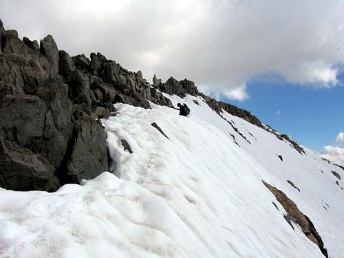
The Ink Wells Trail took us up and over the 11,000ft Scenic Pass next to Dinwoody Peak and provided us with our first glimpse of Gannett Peak some 12 miles away. As fate would have it, a storm rolled in just as we were crossing the pass, with a bit of thunder and lightening in the distance. The Scenic Pass is fairly long and we were smack dab in the middle of it carrying 65 pound packs. It would have taken us some time to get to lower ground, either by going back or continuing forward. So we opted to drop our packs and lay low for a bit. Fortunately, the storm passed quickly and we were able to continue to Echo Lake.
We covered 8 miles the second day, hiking through Floyd Wilson Meadow, crossing numerous streams, and following the melting glacial torrent leaking down from the Dinwoody Glacier. It rained periodically during the day and again there was some violent thunder and lightening, this time coming from the vicinity of Gannett Peak. Thankfully the storm cleared by the time we reached our campsite.
We started to hike through the glacial moraine to get closer to the Dinwoody Glacier, but I lost my footing atop a car-sized boulder and took a nasty fall. I’m usually very sure-footed and balanced, but it was a go-for-it kind of hop between boulders - and I missed the target under the heavy load I was carrying! I landed on my side and whacked my head pretty hard. I was momentarily stunned but there was no serious damage done. (I guess I really am as hard headed as they say.)
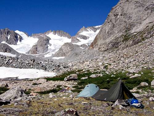
Tom and I decided that we’d gotten close enough to the peak and agreed to camp just before the boulder field, which would leave us with about a 2 mile route to climb and 3000ft gain. So we retreated out of the boulders and made camp at an elevation of about 10,800ft in an area that appeared safe from rock fall.
Rest Day
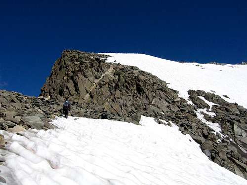
The next morning, we did some camp chores and then hiked up to the cirque to scope out the route for the next day’s climb. What an incredible place! You could spend weeks climbing all of the routes on the peaks in the cirque around Gannett Peak and it will have been time well spent.
Summit Day
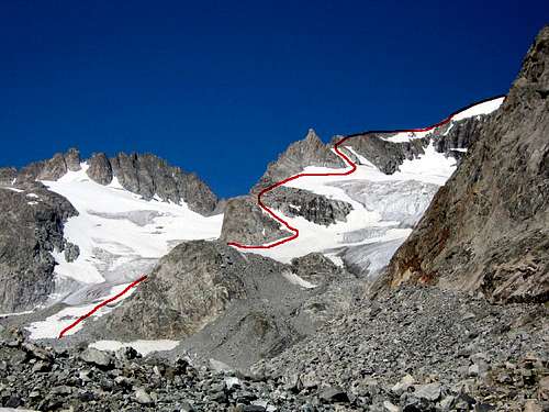
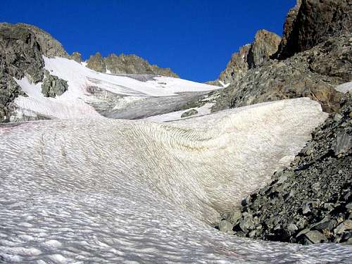
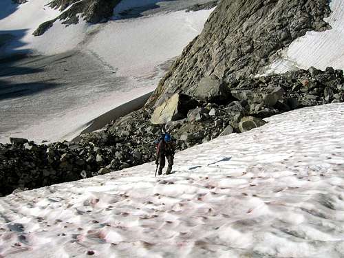
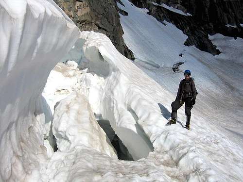
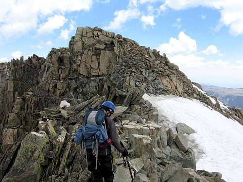
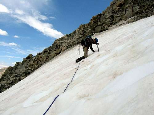
We awoke at 4am on summit day, had some breakfast, and hit the trail just after 5am. Negotiating the boulder field in the dark was interesting but within 30 minutes it was light enough to see without headlamps. It was warm already and the weather seemed ideal for our summit attempt. We reached the Dinwoody Glacier by 6:40am and ascended the initial gentle slope without crampons. Our route passed around the left (east) side of the rock buttress that forms the lower end of Gooseneck Pinnacle Ridge which separates the Dinwoody and Gooseneck Glaciers. We put on our crampons for the final stretch of glacier before reaching the buttress. Some class 3 climbing is required to gain the top of the buttress, which was a bit clumsy wearing crampons, but we managed.
From the top of the buttress, it’s an easy hike across the Gooseneck Glacier to reach the infamous bergshrund that guards the slope leading up to the Gooseneck Ridge. At least, I thought it would be an easy hike. One of my legs poked through a snow bridge in the middle of the glacier. When I pulled it out and looked down into the hole, I saw the dark, emptiness of a bottomless chasm. Not knowing how wide the crevasse was, I moved to the side as gingerly and quickly as I could. (We weren’t roped!) Whew, that was unnerving!
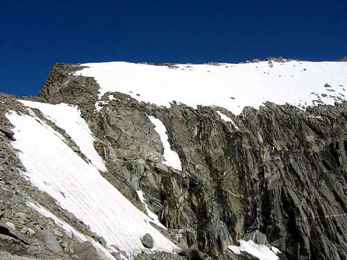
Dinwoody Glacier
Start of the Gooseneck Glacier
Bergshrund on the Gooseneck Glacier
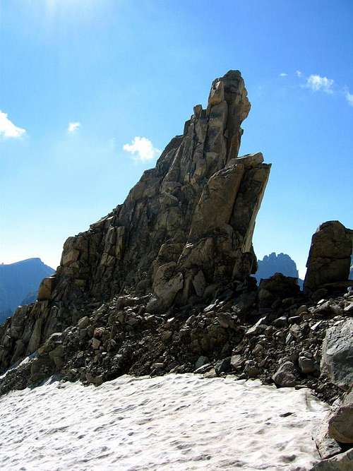
When we reached the bergshrund, Tom and I decided that the snow conditions were good enough that we wouldn’t rope up for the ascent. The slope is steepest right above the bergshrund (~ 55 degrees), but the snow was really soft and slushy. We could sink our ice axes in almost all the way to the ax head for bomber protection while we ascended. By 8:30am we had reached the base of the Gooseneck Pinnacle.After a brief rest, we ascended the class 3 rock to the west towards the summit ridge. One more stretch of snow, and another section of class 3 rock after that and we were on the summit ridge.
Gooseneck Pinncle
Gannett Peak - Summit Ridge
Summit Ridge of Gannett Peak
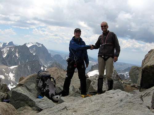
The summit ridge is fairly long and our path continued to alternate between rock and snow, with some significant exposure above the east face of Gannett. We finally reached the summit blocks at 11:30am which rise above the glacial cap of Gannett Peak. Time to celebrate! We stayed up there until 1pm when some distant thunder and rain told us it was time to head back. As though to say farewell, it started to snow briefly just as we were leaving.
Summit Ridge of Gannett Peak
Gannett Peak Summit Blocks
Gannett Peak
Back at the Gooseneck Pinnacle, we decided to place protection for the descent as the snow was even more soft and slushy than it was when we ascended in the morning. We each had a snow picket, an ice screw, a few prussic cords, webbing, a few biners and a 30m 8mm glacier rope. Tom burried the first picket. I descended as far as I could, then placed the second picket. Tom down-climbed past me, and I was hoping he would be able to descend past the bergshrund, but we were about 20 ft short of rope. So he placed the final picket and then I down-climbed past the shrund. Tom followed, still roped, and this time it was his turn to poke a leg through the snow bridge. Fortunately he was able to shimmy out of the hole safely and we were past the bergshrund.
Hasty Retreat off Gannett Peak
Descending the Gooseneck Gully
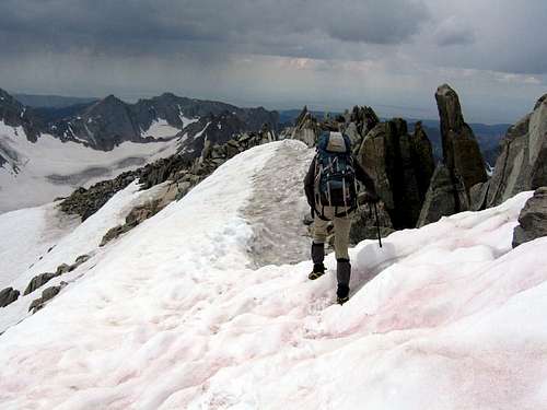
We backtracked the rest of the way down, using sitting glissades whenever possible to hasten our descent, and finally made it back to camp at 7:30pm. It was an awesome 14-hour alpine day!
2-Day Hike Out
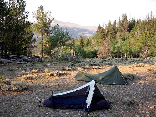
My feet were pretty trashed between the previous long approach and our long summit day. So we only hiked out 6 miles the first day and camped just north of the foot bridge at the far end of Floyd Wilson Meadow. We hiked 7 miles the next day and bagged Dinwoody Peak next to the Scenic Pass. We camped at the edge of the US Wilderness boundary near the Cold Springs trailhead for pick-up the next morning by our Indian guide.
Campsite near Cold Springs TH
Summary
Gannett Peak was both great fun and challenging! Our schedule really worked well for us. I highly recommend this approach for people that are not into long, marathon death marches. Ours was an enjoyable and achievable pace. I bow to the few who can climb this mountain in shorter time and smile at what fools are willing to suffer.
Additional Reading
Check out this excellent trip report by PellucidWombat for how to climb Gannett Peak in a day.
climbed the peak the very next day behind you and had a great time. I understand the bridge fell 4 days later. I tried again this year at the end of August knowing the bridge was out, but the distance between the Bergshrund and the face was so great we could not cross. Don't plan to ever go again knowing the bridge is out as I dont' rock climb or do steep snow faces like the approach up the shaft to the south of Gooseneck
Haven't written since Borah? I think. Hope you have a great time in Sierra Country. I'm trying to figure out how to escape and go do Whitney soon. It looks mellow, high, and fun.
In 2011 I did Kings and then Gannett. We went alpine style. Lot's of moisture on Kings. big snow year. Gannett was just awesome. Unfortunately a fellow perished after falling from the summit ridge. I felt the snow was getting too soft and we were out of there by 11am.
We came in from Pinedale.
Luckily, my partners were very strong 23 year olds. We went very fast, and packed up and got out in three days total.
2nd trail head on private land further up the road!
If you stop in at the library in riverton... they have all of the 7.5 min topo sheets in a metal map cabinet. and there is another trail head further up the road with parking on private land... where you can access and connect with the main trail all off of res land.
Even so I would either let the indians guide and pack me in and out if I was so inclined... however... it's expensive and there are two water crossings on this side that can be problematic if you are walking in early in the season.
making the pinedale side my first choice to walk in. more people and more chances to get help if ever needed. both sides are apx 20 miles one way.
Re: 2nd trail head on private land further up the road!
Thanks for the intel. Note that it is definitely a shorter approach from from the Cold Springs trailhead. (It's about 16 miles vs 20 from Pinedale.) The other big advantage of going in via Cold Springs is that it avoids going up and over Bonnie Pass on summit day.
Children refers to the set of objects that logically fall under a given object. For example, the
Aconcagua mountain page is a child of the 'Aconcagua Group' and the 'Seven Summits.' The
Aconcagua mountain itself has many routes, photos, and trip reports as children.
Parents refers to a larger category under which an object falls. For example, theAconcagua mountain page has the 'Aconcagua Group' and the 'Seven Summits' asparents and is a parent itself to many routes, photos, and Trip Reports.


Comments
Post a Comment