Introduction and Background
This is the story of a return to my favorite place in the world; the Himalaya. It was good to be back, even if it wasn’t my first choice for the year end trip.
I always dream of climbing the big peaks in the Himalaya, but as for now I have to be contented with just looking at them.
First Trip
My first trip to the Himalaya was from late November 2001 to early January 2002. On that trip my beautiful wife and I were planning on climbing Naya Kanga in the Langtang. Just after we got our (non-refundable) plane tickets, it was found out that she was pregnant. In the end we decided to go anyway, but stuck to strictly trekking. We did a modified version of the Annapurna Circuit, taking in the Annapurna Basecamp south as well. We completed 216 miles/348 kilometers over a 22 day trek, but we never could go that high. The journey was great though and the mountains absolutely spectacular.
A Return
I had been saving for another trip to the Himalaya to do one of my dream climbs; Ama Dablam, which I hoped to climb in the next year or two. When my son (10 year old Kessler) heard that I wanted to go back to the Himalaya, he begged and begged for me to take him with me to the Himalaya. I actually wanted to do Ama Dablam and alas, he was too young, but I told him that if he did really well in school, I would allow him to pick one of our trips.
Well anyway, Kessler did really great in school. I had also warned him that going to the Himalaya would require much practice and conditioning. Year round we climbed some the highest mountains in Colorado (even in the dead of winter) and did many other training trips.
In the end, I still wanted to save my next Nepal trip for Ama Dablam, so I tried to talk him into picking Vietnam, Cambodia, and Laos since neither of us had been there and I wanted to climb some peaks, go caving, and do some rafting there, all of which I thought that Kessler would seriously enjoy. Further, I could only get time of winter and it would be really cold in the Himalaya then.
In the end though, Kessler just had to go to the Himalaya. He really wanted to visit Mount Everest and the other places he reads about.
So, the Himalaya it was. It turned out to be a great trip. We ended up seeing some incredible scenery, enjoying the wonderful people that live there, climbed several peaks, visited three major basecamps, and the trip ran almost flawless except for a scary incident when a Sherpa porter we were with got sick for part of a day.
This is our story.
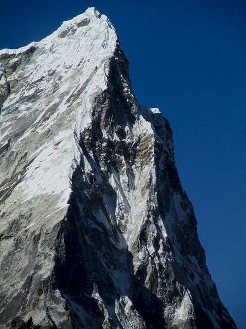
![Cholatse]() The spectacular Cholatse Peak as seen from the summit of Nangkartshang Peak on December 19 2012.
The spectacular Cholatse Peak as seen from the summit of Nangkartshang Peak on December 19 2012.
![Nuptse]() The impressive Nuptse as seen on December 23 2012.
The impressive Nuptse as seen on December 23 2012.
![Hamugon]() Kessler, me, and our Sherpa porter on a subpeak of Hamugon.
Kessler, me, and our Sherpa porter on a subpeak of Hamugon.
Schedule and Acclimatization
This was our acclimatization schedule. Climb high, sleep low is the conventional wisdom concerning the matter. We live at 6300 feet / 1920 meters which also helps with acclimatization. We also climb to over 13,000+ feet / 4000+ meters on a regular basis, year round.
| DATE |
LOWEST ELEVATION |
HIGHEST ELEVATION |
SLEEPING ALTITUDE |
| 11-Dec |
8179 feet / 2493 meters |
9534 feet / 2906 meters |
9534 feet / 2493 meters |
| 12-Dec |
8924 feet / 2720 meters |
11290 feet / 3441 meters |
11290 feet / 2720 meters |
| 13-Dec |
11122 feet / 3390 meters |
13000 feet / 3962 meters |
11290 feet / 3390 meters |
| 14-Dec |
10667 feet / 3251 meters |
12669 feet / 3862 meters |
12669 feet / 3251 meters |
| 15-Dec |
12303 feet / 3750 meters |
14960 feet / 4560 meters |
13081 feet / 3962 meters |
| 16-Dec |
13000 feet / 3962 meters |
16100 feet / 4907 meters |
13081 feet / 3962 meters |
| 17-Dec |
13000 feet / 3962 meters |
14500 feet / 4420 meters |
14468 feet / 4410 meters |
| 18-Dec |
14460 feet / 4407 meters |
15540 feet / 4737 meters |
14468 feet / 4410 meters |
| 19-Dec |
14460 feet / 4407 meters |
16679 feet / 5084 meters |
14468 feet / 4410 meters |
| 20-Dec |
14468 feet / 4410 meters |
16896 feet / 5150 meters |
15584 feet / 4750 meters |
| 21-Dec |
15584 feet / 4750 meters |
18238 feet / 5559 meters |
15584 feet / 4750 meters |
| 22-Dec |
14600 feet / 4450 meters |
16568 feet / 5050 meters |
16207 feet / 4940 meters |
| 23-Dec |
16207 feet / 4940 meters |
17800 feet / 5426 meters |
17008 feet / 5184 meters |
| 24-Dec |
14042 feet / 4280 meters |
18373 feet / 5600 meters |
14042 feet / 4280 meters |
| 25-Dec |
12057 feet / 3675 meters |
14107 feet / 4300 meters |
12057 feet / 3675 meters |
| 26-Dec |
11290 feet / 3441 meters |
13058 feet / 3980 meters |
11290 feet / 3441 meters |
| 27-Dec |
8550 feet / 2606 metres |
11680 feet / 3560 metres |
8566 feet / 2611 metres |
| 28-Dec |
8179 feet / 2493 meters |
9321 feet / 2841 meters |
9321 feet / 2841 meters |
![Summit]() The summit of Kala Pattar as seen on December 24.
The summit of Kala Pattar as seen on December 24.
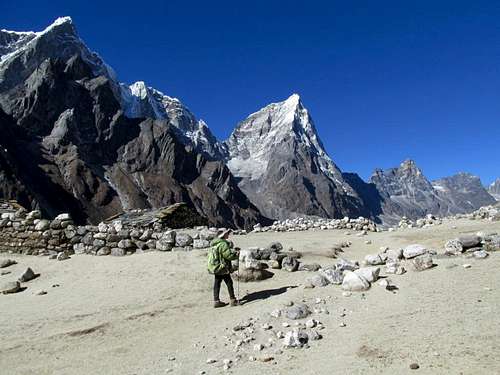
December 11: Lukla to Bengkar; The Trek Begins
It was a long trip to get to Nepal, but we (Kessler and I) finally arrived the evening of December 11. We immediately wanted to head to the mountains so we booked a morning flight to Lukla.
Because of the fog in Kathmandu, all domestic flights were delayed and we had to wait around the airport for several hours. There wasn't much to do except watch the few monkeys that hang out around and inside the airport. Finally, in the early afternoon we were off!
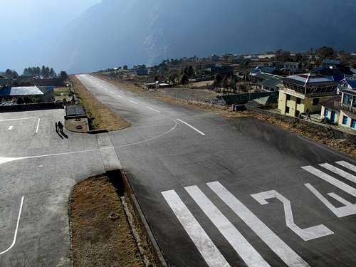
Even flying into Lukla to begin the trek is an exciting experience. It's hard to tell from the photo how steep the runway is. It's an average 12% grade. The runway is so steep because it allows the planes to accelerate as much as possible before hitting the end of the runway during takeoff. At the end of the runway is a 3000 foot drop into the gorge, so you want to be at liftoff before the end. The steepness of the runway also helps during landings because they hit the runway going up hill to slow down as quickly as possible. To our backs is a 20,000 foot/6000 meter mountain, so you don't want to slam into it while landing (just before landing wrekages of planes that didn't make it can be seen on the mountainside). There is no radar or anything else at the airport, you just say a prayer, hold your breath during takeoffs and landings and hope the pilot is good.
![Lukla Airport]() Lukla Airport.
Lukla Airport.
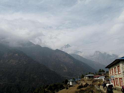
After arriving in Lukla, and meeting two porters, we ate lunch and walked to Bengkar very quickly. Most people stay the night in Phakding, but we were restless from the long journey and wanted to push on. Clouds obscured most of the peaks along the way. We saw a walking stick insect in the evening. We stayed at a lodge next to a nice waterfall before heading to bed.
![Lukla]() Lukla; the beginning of the trek.
Lukla; the beginning of the trek.
December 12: Bengkar to Namche Bazaar
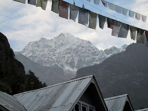
We finally got a good night sleep (the first in many days) since it's much quieter in the mountains than it was in Kathmandu. It was 34F (1C) in the morning and we actually got some views of Thamserku. The clouds quickly rolled in though and it began to snow lightly.
It snowed lightly the entire walk to Namche Bazaar. In the late evening it finally cleared somewhat and we got some nice views of some of the surrounding mountains. We explored Namche and emailed home before heading off to bed.
![Thamserku]() Thamserku from our lodge on December 12.
Thamserku from our lodge on December 12.
December 13: Thame Gompa; A Snowy Experience
We awoke to more snow and cloudy skies. Most other trekkers decided to hang around Namche Bazaar, but we decided to hike to Thame Gompa through the snow.
One porter stayed with us and we sent one back to Bangkar to pick up the pillow I left there the night before. It’s hard to sleep without my pillow since I am used to having my arm around my wife at night. I didn’t tell the porters that this is why I needed it though. At least I didn’t send them back for a teddy bear or something.
After calling my wife Kimberly, we hit the trail while it was snowing. The snow really didn't accumulate much, so it wasn't a problem, but it did hide the spectacular mountain views we were supposed to have. Even though it was overcast and snowing, the villages were interesting as were the monasteries.
We did get a few peekaboo views as we headed up the trail, but most of the peaks were hidden. We did pass many yak trains, saw Tahrs, the Himalayan mountain goat, and several pheasants. Also passed was some interesting artwork on the cliffs and several frozen waterfalls. We also saw an interesting natural arch at the bridge across the river as well.
Because it was cloudy, we were unable to see into Tibet, but we made our way to the interesting village of Thame. Not many trekkers or climber come here and in December, even less, so what lodges there were appeared to be closed for the season. Our porter was able to find someone to cook us lunch and the people as the lodge were really happy to see us.
After lunch we climbed up the hill to visit the impressive Gompa. The clouds also began to break and we got some occasionally views of the lower mountains.
On the way back it began to snow harder and the bad weather stuck with us until well into the night.
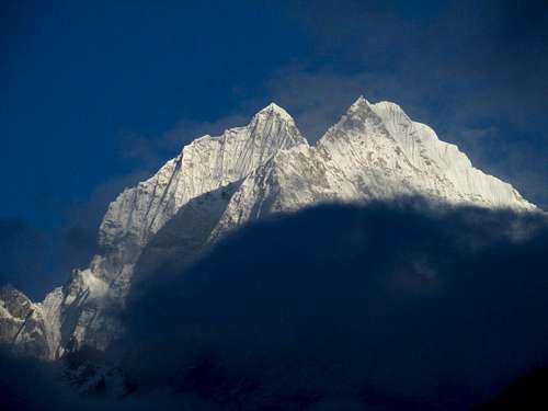
![Thamserku]() Thamserku finally breaks through the clouds.
Thamserku finally breaks through the clouds.
December 14: Namche Bazaar to Tengboche; The Spectacular Views Begin
Today was one of the most beautiful days ever and the most spectacular to date on this trip. The views of Everest, Lhotse, Nuptse, Kangtega, Ama Dablam, etc., were spectacular.
Tengboche was our destination. On the way up we met someone from Singapore who was really altitude sick. We advised him to descend, but he pushed on to Tengboche.
Once at Tengboche we rested and admired the views of all the surrounding mountains. The sunset was really beautiful and after dark we saw several shooting stars, including the biggest and brightest one that I have ever seen.
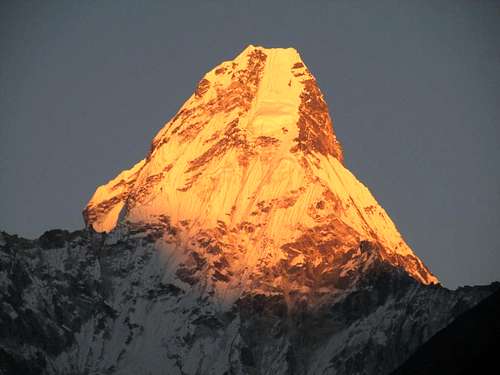
![Ama Dablam]() Sunset on Ama Dablam from Tengboche.
Sunset on Ama Dablam from Tengboche.
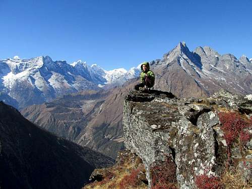
December 15: Hamugon [Peak]; A Challenging Climb
Today was another great day. We awoke to 23F (-5C) and climbed Hamugon, the peak above Tengboche, which was much more difficult than expected.
The first 1/3 of the climb was easy and with spectacular views. We saw many pheasants along the way. On the way up we witnessed a helicopter landing below in Tengboche. We theorized that it was the sick person from Singapore we met the day before (this assumption was correct as we were to find out when getting back to Tengboche)
The next 1/3 of the climb up Hamugon was an enjoyable and challenging class 3 scramble. The next 1/3 of the climb was a scary 4th class ascent on steep grass covered ledges.
The porter and climbing Sherpa/porter didn’t climb the last 1/3 of the ascent with us. Kessler and I finished the climb, but it was tough and scary in several places. The views were spectacular, but getting down was also challenging!
After climbing Hamugon, we ate lunch in Tengboche and visited the Gompa. We then pushed on to Pangboche. The trail was icy in a few places, but the sky was beautifully clear all day and the views were spectacular.
![Hamugon]() Kessler on the ridge while climbing Hamugon.
Kessler on the ridge while climbing Hamugon.
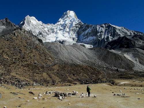
December 16: Ama Dablam Basecamp/Un-named peak; Up Close and Personal With One of the Word's Most Beautiful Mountains
Today was another beautiful and clear day. We awoke to 22F (-6C) and walked to the Ama Dablam Basecamp and climbed a minor peak near Mingmo. The trail was moderately steep at first, but not bad at all. All along the way we got some really spectacular views of the mountains. We got really close to Ama Dablam and the glaciers and we explored around the basecamp before heading back down. We saw some more pheasants.
The evening sunset was another really spectacular one!
![Ama Dablam Base Camp]() Kessler at the Ama Dablam Basecamp.
Kessler at the Ama Dablam Basecamp.
December 17: Pangboche to Dingboche
It was yet another beautiful and clear day. We awoke to 21F (-6C) and hiked from Pangboche to Dingboche. The mountains are very beautiful, but prices kept rising as we went higher.
I almost got shoved off the mountain by an angry yak! Usually yaks appear to be gentle creatures, but this was must have been in a foul mood because it shoved me right off the trail as it passed.
Peak 32, Ama Dablam, Lhotse, Island Peak, etc., all put on a good show for us in the afternoon and evening.
![Approaching Dingboche]() Approaching Dingboche.
Approaching Dingboche.
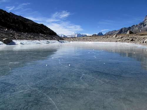
December 18: Ama Dablam Lakes; Icy Fun
It was yet another gorgeous day. It was very windy and sunny except for a few high cirrus clouds (which may indicate an approaching storm).
We hiked up to the Ama Dablam Lakes and to a minor peak. The views of the frozen lakes and surrounding peaks were really spectacular. We were right up near the glaciers and we could see many peaks, including our first views of Makalu.
Kessler loved the frozen lakes and we played for many hours throwing ice blocks across the lakes. The lakes were cracking and groaning despite the 12”+ (30+ cm) ice thickness. On the way down we passed some slower groups.
We were hoping for good weather for the next few days, but were a little worried about an approaching storm. I also had my first minor stomach trouble, but luckily it was very minor.
![Frozen lakes]() The frozen Ama Dablam Lakes.
The frozen Ama Dablam Lakes.
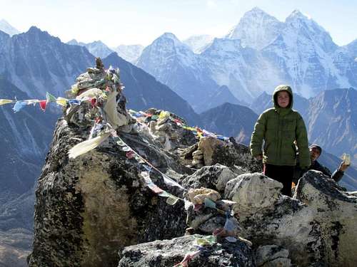
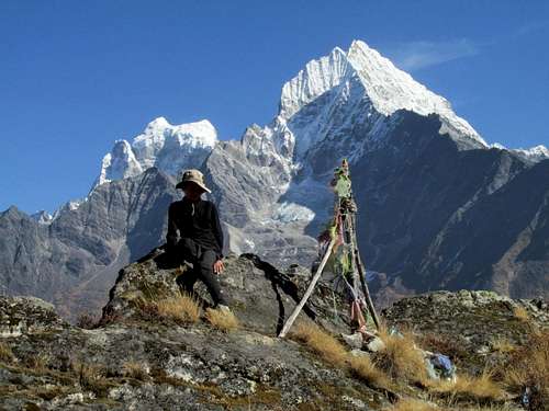
December 19: Nangkartshang Peak; A Spectacular Viewpoint
Today was another spectacular one and we climbed Nangkartshang Peak. At 16,676 feet/5083 meters, this would be the highest Kessler and I had been for a few years (November 2007). We awoke to 19.8F (-7C) and again, it was sunny, but very windy and dusty.
This climb was a good one and was fairly straightforward. It was a much easier ascent than Hamugon which we climbed a few days earlier.
The views were the most spectacular yet and we got some unusual views of Cho Oyu. Makalu was really spectacular as well, as were our different angle views of Ama Dablam, Cholatse, and Toboche.
After climbing the peak we returned to Dingboche. More people showed up at the lodge and the porters were all gambling. They taught Kessler how to play tigers and goats, a board game.
![Nangkartshang Peak]() Summit of Nangkartshang Peak.
Summit of Nangkartshang Peak.
December 20: Dingboche to Chhukhung/Island Peak Basecamp; A Long, But Beautiful Day
It was a beautiful, but difficult day. We walked all the way from Dingboche to Island Peak Basecamp and all the way back to Chhukhung. We hoped that we didn’t wear ourselves out too much for the next day’s climb.
It was really windy and cold all day and there were lenticular clouds over the peaks, especially Lhotse. It gradually got clearer in the afternoon, but the wind was really cold and brutal. The route was very long as well and Island Peak Basecamp is at 16,900 feet/5151 meters. We found that Basecamp was abandoned. The yaks up here are really hardy creatures because they didn't seem to mind the wind and cold.
The walk was really spectacular, but we were really glad to make it back to Chhukhung. At 15,600 feet/4755 meters, this was our highest sleeping altitude in quite a while.
![Ama Dablam]() Sunset clouds and Ama Dablam.
Sunset clouds and Ama Dablam.
December 21: Chhukung Ri; A Cold, Windy, and Spectacular Ascent
It was extremely windy last night, but we awoke to only a stiff breeze. The climb of Chhukhung Ri was on!
After a nice breakfast of pancakes and porridge, we headed up the mountain. We made good progress and admired the yaks, including a huge one that was the biggest that I ever seen. He must have been the alpha male.
We continued up the steep track to the saddle between the two Chhukhung Ri peaks. We decided to climb the lower peak (17,772 feet/5417 meters) first. It was very windy and cold on top, but the views were spectacular. After climbing the lower peak, we descended to the saddle and climbed the higher peak (18,238 feet/5559 meters). It had some tricky scrambling and the climb took much longer than it looked.
The exposed scrambling was similar to Pyramid Peak in Colorado and Kessler got really tired just before the top. It was the highest peak that he had ever climbed.
The views from the higher peak were even more spectacular than the first peak, but it was very windy and cold so we didn’t spend that much time on the summit.
We were right there in front of the huge faces of Nuptse and Lhotse and could look down on all the glaciers. The views of Makalu were spectacular as well. It was the grandest mountain scene that I have ever laid eyes on.
After enjoying the summit, it was a long hike back to Chhukhung. It was a very rewarding climb, but the second peak was little harder than expected and due to the long and tiring day before (Dingboche to Island Peak Basecamp and back to Chhukhung) and the extreme winds and cold, it wasn’t that easy of a day.
![Chhukung Ri]() On the summit of Chhukhung Ri.
On the summit of Chhukhung Ri.
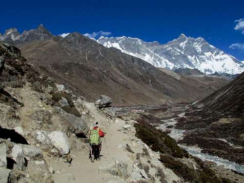
December 22: Chhukhung to Lobuche; Fast Walking Followed by a Bath in the Ice Water
We awoke to 7F (-14C) this morning, but there was only a light breeze. We did the long hike from Chhukhung to Lobuche under clear skies and made excellent time. We passed everyone else on the trail, even though we walked farther than most (we were well acclimatized now because we had climbed several peaks by now). It took us one hour Chhukhung to Dingboche, another 1 hour 20 minutes to Dhugla, and another 1 hour 15 minutes to Lobuche.
The mountains were beautiful, but the afternoon was quite windy. Along the way, we visited various memorials to the climbers that have been killed on Everest and other nearby mountains.
At Lobuche, Kessler and I took a very cold bath just below the spring. Most of the water was frozen, but we had been walking and climbing several days without a bath or shower, so we took a bath in the freezing ice water anyway. Kessler only went up to his ankles in the water and washed from there.
After washing some of our clothes in a bucket, we headed for the Pyramid, a high altitude research station. The wind really picked up and it became very cold.
![Taboche and Cholatse]() Taboche (left) and Cholatse as seen on the route to Lobuche.
Taboche (left) and Cholatse as seen on the route to Lobuche.
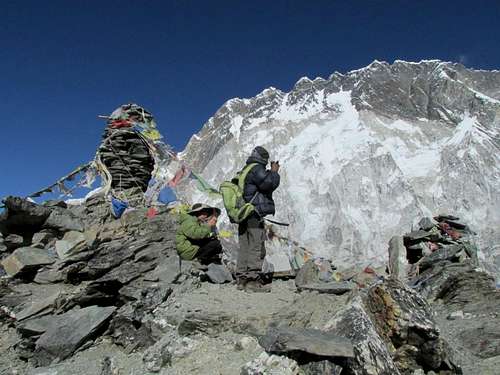
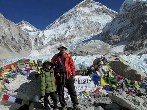
December 23: Everest Basecamp; Views, Wind, and Speghetti
The wind really blew hard all night and it sounded like the roof was going to blow off the tea house. By morning it was 2F (17C) inside our room. I didn’t take an outside temperature until the sun was fairly high in the sky and even then it was 0F (-18C).
After breakfast, we walked from Lobuche to Gorak Shep, which at 16,995 feet/5180 meters, is the highest settlement in the world. After lunch we headed for the Everest Basecamp. It actually took much less time than it was supposed to (according to the guidebooks) and we made it in 1 hour and 25 minutes. It felt good to be walking so fast since it meant that we were acclimatized.
The mountains were certainly spectacular here and the walk was well worth it. We say one fur ball pika long the way. At first, I was confused as to where the Khumbu Icefall spills out of the Western Cwm because it is so hidden until you are there. The basecamp was actually much cleaner than I expected it to be and there was actually hardly any trash other than a few left over posters and old prayer flags.
Kessler wanted to spend a lot of time poking around and playing at basecamp. We spent 1.5 hours there before I talked him into going back down.
At Gorak Shep we had a nice spaghetti dinner before heading off to bed.
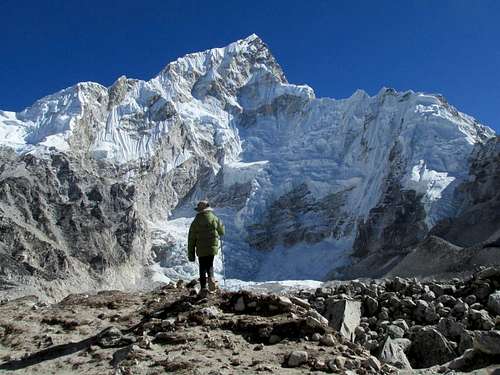
![Base Camp]() Everest Basecamp.
Everest Basecamp.
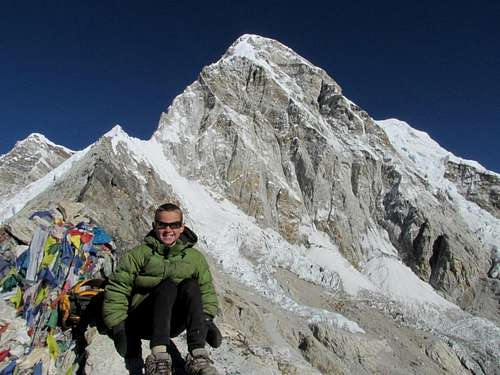
December 24: Kala Pattar; Gorgeous Views, a Sick Sherpa Porter, and a Change in Plans
Today was quite eventful and in some ways a little scary.
Because of the cold, I didn’t want to get up early and thought that we should wait until later for warmer weather and better lighting conditions for photos.
All went well except for one scary moment when the Sherpa got sick. When we climbed Kala Pattar, it was -19F/-18C and fairly windy. I wanted to sleep in until it got warmer, but the Sherpa wanted to climb early in the morning. Because it was so cold and the sunlight was beckoning up higher, Kessler and I hurried very quickly 16,995 feet/5180 meters to 18,373 feet/5600 meters making the 1400 feet/420 meter climb in an hour, which is much faster than normal. Since we had no idea that the Sherpa was feeling sick, we climbed both little peaks around Kala Pattar.
The Sherpa got sick trying to keep up, but we didn't know that he was sick until we got down and he couldn't walk well. He wouldn't admit that he was sick, but we and others could tell. It was apparently a matter of pride that he couldn't keep up with Kessler and the Sherpa people have a hard time admitting to sickness, so we had no idea (he was apparently a well known climbing Sherpa whom had been to Everest several times as a porter, which made it harder to admit sickness).
We were supposed to head back to Lobuche and climb the Lobuche Pinnacles today, and cross the Cho La the next day, but since the Sherpa got sick we descended quickly to Periche and divided the load between the other porter and myself.
We got the Sherpa back down to a lower elevation and after taking Diamox, he was OK again and was back to normal and going strong. We were very glad everything worked out well. I would have felt really guilty if anything had went wrong. The sickness never was life threatening, but it was difficult to try and talk the Sherpa into descending.
Other than that incident everything ran perfectly. It was cold, but we had clear and cold skies the whole time. It was so spectacular and I took many photos so far. So far, the people in the mountains were really nice and the mountains were great.
Focusing on the good part, Kessler beat his altitude record set on Chhukhung Ri, but only barely. The Sherpa felt bad that we had to change our plans, but we assured him that we were fine with the change of plans and wouldn’t mention him by name. We gave him part of his tip early to show that we weren’t upset at all.
![Pumori from Kala Pattar]() Kessler on the highest summit of Kala Pattar.
Kessler on the highest summit of Kala Pattar.
December 25: Pheriche to Phortse Tenga; A Visit From Santa Clause
It was 2F (-17C) in the morning which was colder than I expected since now we were at the comparatively low elevation of 14,042 feet/4280 meters. I didn’t sleep well for the first half of the night because of all the barking dogs at Periche (they were not a problem in the other places we stayed).
Before leaving Periche, we visited the Everest memorial for all the climbers that have been killed on Everest. Along the way to Phortse Tenga, we saw two very colorful birds that looked similar to peacocks. We also saw a mountain goat.
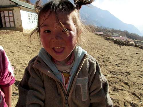
About half way along the trail, there was someone dressed as Santa Clause and handing out candy canes to all the passing trekkers! The children in Phortse were very friendly and came out to greet us as we walked past. Other than that, it was a fairly uneventful day.
![Nepali child]() Because my 10 year old son was with us, the Nepali children would all run to greet us and especially to meet Kessler. This is in the village of Phortse.
Because my 10 year old son was with us, the Nepali children would all run to greet us and especially to meet Kessler. This is in the village of Phortse.
December 26: Jaro Ri; Awesome Viewpoint and Challenging Surprise
Today we walked from Potorse Tenga to Namche Bazaar. It was another sunny day and 12F (-11C). It was an up and down route all the way and we decided to go through Khumjung and Khunde visiting the Hillary School, Gompa, and hospital.
We also decided to climb Jaro Ri, the highest point on the south side of these two towns. It was actually harder than expected and was a stiff rock scramble with some bushwhacking. The views were awesome though and we saw some colorful pheasants.
After climbing the peak and admiring the views, we descended to the Syangboche Airstrip and then down to Namche.
![From the summit]() Kantega and Thamserku from the summit of Jaro Ri.
Kantega and Thamserku from the summit of Jaro Ri.
December 27: Chhorkung Ri; Last Big Views
We had to get just one more small peak above Namche Bazaar in before heading back down, so we decided to climb Chhorkung Ri before heading back down. We also descended to the Sagarmatha Park Headquarters and Museum and got several last photos of Everest and the surrounding peaks before our descent.
The last view of Everest, Lhotse and Ama Dablam was actually below Namche Bazaar along the trail (we missed the views on the way up do to clouds). After Bengkar, there are no more really big peaks visible, but the walk is still very beautiful with the forest, river, and views of the "small" peaks.
![Everest]() One of our last views of Everest, this one from the park headquarters on the outskirts of Namche Bazaar.
One of our last views of Everest, this one from the park headquarters on the outskirts of Namche Bazaar.
December 28: Phakding to Lukla; Winding Down
Kessler got sick last night, but we were still glad that it happened at the very end of the trek rather than at the beginning or middle. Other than that, the walk back to Lukla from Phakding was rather uneventful.
We had beautiful clear skies and a morning temperature of 33F (1C) which was a welcome relief from the cold.
In the afternoon we bade farewell to our porters and gave them their tips and also let them keep the backpacks they had been carrying. They were very happy to receive them.
![Thamserku]() Our last view of Thamserku.
Our last view of Thamserku.
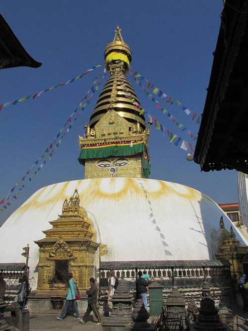
December 29: Swayambhunath; Monkey Temple
After flying back to Lukla in the morning, we walked most of the way to Swayambhunath, known as the "Monkey Temple" and set on top of a hike hill in Kathmandu. We did take a wrong turn and flagged down a taxi for a short ride, just so we'd know how to get there.
After arriving at the base, we climbed the stairs up the big hill and spent some time around the temple admiring all of the architecture (and the monkeys of course) before walking most of the way back to Thamel.
![Swayambhunath]() Swayambhunath.
Swayambhunath.
December 30: River Trail/Chitwan; Welcome to the Jungle
We took a hike along the river to look for wildlife. We did see one rhino from quite a distance, but no rhinos up close. We saw a lot of bird life though.
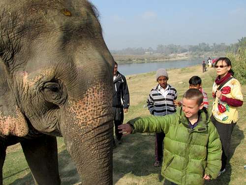
![Elephant]() Elephant at Chitwan.
Elephant at Chitwan.
December 31: Chitwan Trek; Last Adventurous Day Before Heading Back to Kathmandu
In the morning we took a nice elephant ride to look for rhinos, tigers (sightings are rare), birds, spotted deer, barking deer, etc, but we didn't see any rhinos (last time I was here 11 years ago, we saw several). We did see lots of deer and birds.
We then took a canoe ride down the river and saw many marsh mugger crocodiles (including several big ones) and birds. It was then elephant bathing.
We then did a hike through the jungle to look for animals. We saw more deer, birds, a crocodile, and a monkey, but unfortunately still no rhinos. After that was a visit to the elephant breeding center.
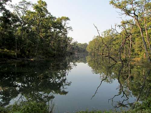
![Lake]() A lake seen on our trek through Chitwan.
A lake seen on our trek through Chitwan.


Comments
Post a Comment