My primary motivation for choosing West Virginia as my next destination was its status as the closest mountainous area I had never seen before. With a state nickname proclaiming itself as the “Mountain State,” it surely had to live up to its moniker. So with a crowded itinerary and four available days, I took off from eastern Kentucky early Friday morning and entered West Virginia for the first time.
My first priority was to see the New River Gorge. I read about this amazing feature numerous times in media ranging from geography books to the West Virginia state quarter. I had seen enough pictures to instill a noticeable excitement toward seeing it live and in person. After winding through the foothills for a while within the Allegheny Plateau area of the state, I suddenly found myself crossing the New River Gorge bridge itself. After a hundred miles of forested mountains and valleys, the giant empty space of the gorge sprang upon me. I quickly turned around to access the visitor center on the east rim, gateway to the New River Gorge National Recreation Area.
After walking the easy path to the first viewpoint at the Canyon Rim center, the giant scale of both the gorge and the arch bridge appeared within moments, and they vied for attention. The bridge is an amazing structure, the kind that takes several years to engineer and complete. But the gorge over which it passes has been crafted for several millions of years, crafted by the steady hand of the New River. The name of the river is sort of a peculiarity, because its course is so old that it flows westward from the eastern Appalachian Mountains, rather than follow today’s general slope of the land to the ocean. It is hard to fathom such a length of time, yet it is easy to appreciate the marvel that has slowly evolved within it. The river looks deceptively small from the rim here because it is nearly 1500 feet below. The forests around it have a slight bluish tint to them, though not as noticeable as the aptly-named Blue Ridge Mountains a few hundred miles south. It was a wonderful backdrop for some photographs, but I still felt like I was outside looking in, so I checked out my options for hiking.
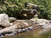
While I was at this area of the rim, I found the Endless Wall Trail and decided to explore it before descending into the gorge farther south. The trail’s level route runs mostly next to the canyon rim’s precipitous cliff edges, as well as through the forest separating the gorge from the county road. Just a half-mile walk along a segment of the road makes this a nice loop trail. The sense of real danger at the cliff edges brings you closer to the gorge without actually going down into it. Views here are quiet and just as spectacular as anywhere else along the rim, particularly at Diamond Point. I climbed down one of the more accessible rock faces and toyed with the idea of bushwhacking to the river, but I decided instead to access the river upstream at the Glade Creek trailhead and camping area. After about an hour’s travel time around mountains and across remote gravel roads, I reached the camp.
Seeing the New River up close, from its banks, was even more impressive to me than the grand views from the rim above. It felt like a truly wild setting. The central flow of the river was exceptionally swift and quiet, presumably flowing as fast as water can without disbanding into a chaotic jumble of rapids. Large rocks were scattered on and away from the river bank, protruding above the calmer side waters. They were great stepping stones above the surprisingly deep waters not far from shore. Under the clear skies and beside the approaching shadows from the canyon walls, I hopped upriver and acquainted myself with the new scene around me. Once I returned and set up camp in the fading daylight, I squeezed in a quick hike up the Glade Creek Trail. Along the first mile, the pools of Glade Creek reflected a vibrant array of colors. The mud on the banks was an intriguing shade of purplish-brown underneath the darkening forest. The shallow areas of the pools allowed veiled glimpses of the mud that blended into bright blue channels of deep water. The pools were perfectly still at first and then soon accented with the tiny splashes of intermittent raindrops. As I hiked southward, the rain gradually intensified, but I continued until the impending darkness forced a turnaround. The return hike of a mile or two back was soggy but otherwise uneventful. I took in all the scenery that the daylight could provide, and then I had all night to dry off before heading further east in the Appalachians.
Glade Creek Area.
The New River steaming on a late summer morning.
George Washington-Jefferson National Forest
Rain continued to fall softly through the night, but I awakened to comfortable dryness thanks to my tent and an additional waterproof jacket stretched across the roof. I think the tent would have managed to repel the rain on its own, but I decided to reinforce it in an uncharacteristic bit of over-preparedness. The steaming New River on a chilly September morning gave me one wonderful sight to remember before I packed up for Virginia. This area of West Virginia is fairly remote, so it took me almost an hour on the roads to circle around to the interstate highway, which passes over Glade Creek at almost the point where I hiked the last evening. Heading east, I reached the Virginia state line, where a sign promised access to the Allegheny Trail within Jefferson National Forest. It sounded like a good time, so I happily took the exit, grabbed a sturdy walking stick near the trailhead, and hiked northward in the Allegheny Mountains without any particular destination.
Along the Allegheny Trail near WV-VA border.
Looking west from Shenandoah Mountain.
Nice view of the Alleghenys.
Battle of McDowell trenches.
The trail was pretty level through the temperate hardwood forest and scattered moist creek beds. This section of the trail skirts the West Virginia-Virginia state line, and at some point I walked back into West Virginia before I found an open area suitable for pictures of the forest-covered mountains. To elevate my vantage point further, I tried with eventual success to navigate a steep and slippery slope up the mountainside. The climb was only possible with the aid of abundant tree branches and saplings that allowed me to pull myself up, but I made it with only minor scratches and earned my photographs. From there, it was sort of a short controlled fall down the slope and a return hike to my vehicle waiting for me in Virginia. Along the way, I picked up a Virginia souvenir rock from a random dry creek bed within the national forest.
After a quick afternoon meal, I traveled northeast into the Shenandoah Valley area and accessed a historic area of the George Washington National Forest from the east. On Shenandoah Mountain lies the battle ground of the Battle of McDowell, fought during the Civil War in 1862. This was one of the clashes that were part of Confederate General Stonewall Jackson’s valley campaign. Evidence of the trenches strategically dug into the mountain still exists, though after 150 years of erosion, the trenches are now mostly filled. Part of the interpretive trail that I walked shows a reconstruction of how the trenches appeared during the war. This neat area of American history is also complete with stretching views of the central Appalachian ridges and valleys to the west. The buckling and folding of the earth’s crust here was something neat to behold from such a bird’s eye view.
Evening was settling in and I continued west from the Battle of McDowell site in search of a place to camp. After leaving the Shenandoah Valley, I re-entered West Virginia and found a quick resolution to my search at a Monongahela National Forest campground. I spent a calm evening here beside a warm crackling fire that really burned well in spite of all the available wet firewood. It only took a year or two, but I have finally learned how to properly build fires.
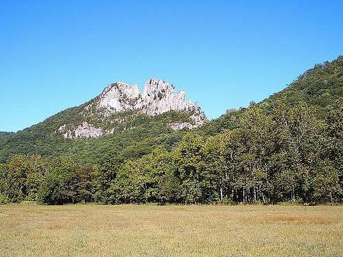
Spruce Knob-Seneca Rocks
Potomac River headwaters beside Seneca Rocks.
Seneca Rocks through the forest.
My campground was in the neighborhood of the Spruce Knob-Seneca Rocks Recreation Area, so the next morning I was able to get an early start at my next destination. Traveling north from my campground, I momentarily bypassed Spruce Knob and headed straight for the striking Seneca Rocks formation a little farther north. There was ample parking available at the discovery center, and after momentarily browsing the exhibits I started on the trail leading to the top of the rocks. A bridge leads over some of the uppermost headwaters of the Potomac River and then to the West Side Trail, which switchbacks up the ridge for about a mile and a half. The ascent through the forest was only mildly exhausting, and I comfortably reached the rockier sections of the ridge in under an hour.
Fronting the Seneca Rocks formation itself, there was a large sign and an observation platform discouraging access to the rocks. The views are roughly the same, no doubt, but the destination of this trail is Seneca Rocks, not a viewing platform near Seneca Rocks. Like the other hikers there, I promptly bypassed the sign and started to scramble up and over the protected vertical fins of Tuscarora quartzsite high above the river valley. It was very enjoyable low-level climbing and I reached one of the high points along the northern side of the rocks. The view just feels better when I am sitting on a pinnacle with that feeling of being on top of it all. I snacked a little bit and admired the numerous Appalachian ridges to the west and east, as well as Germany Valley that stretched southwest toward Spruce Knob. After admiring that scene, I was able to squeeze through a narrow gap in the rock and inch a little further south along the ridge to a more unobstructed view. At this point on the sheer edge, I could now also see some of the numerous climbers roped to the sheer rock faces below me, which was a neat perspective.
The views at or near the summit of Seneca Rocks.
North.
East.
West.
Can you spot the climbers?
Seneca Rocks, West Virginia.
Before hiking down, I grabbed a quartz souvenir rock and a few photographs, and then I headed south for the visit to Spruce Knob that I postponed earlier in the morning. The road to the summit parking area was a long and winding byway through the Seneca Creek Backcountry area. Fifteen or twenty miles later, the road eventually led me to a parking area near the Spruce Knob observation tower. The tower marks the state high point of West Virginia, and just a short half-mile path separates it from the parking area. I briefly checked out the crowded view from the tower, and then I found a quieter and more preferable spot near the path looking west on a boulder slab. The altitude of the area gives it more of a unique alpine feel than the rest of the Monongahela National Forest. There are shorter gnarled trees and ground-hugging berry plants. The height of the mountain and the gaps in the forest allow for neat views of the adjacent ridges. I was not really tired from the driving and the minimal walking, but the scene was such that I relaxed for a good while before driving back down.
View from Spruce Knob.
Dolly Sods Wilderness.
I traveled back north toward Maryland with another quick stop for photographs at Seneca Rocks. Near the state line, I made a regrettable decision to explore the Dolly Sods Wilderness for camping options. The road into the wilderness was far rougher than anything I was prepared for in my low-clearance coupe. I mindlessly plodded ahead at the beginning, and as the rocks and potholes mounted, I reluctantly continued so the trek would not be in vain. But then, as I reached the mountain top and I saw only a bumpy gravel road stretching ahead for miles, my mindset changed. I parked and walked off-trail to view the east-facing vista for a moment before tediously returning down the rough mountain road. The ordeal took a good part of my afternoon, so I was eager to find a place to camp ahead in Maryland. There was one at Swallow Falls State Park, tucked in the extreme western forests of the Old Line State. At twilight, I reached the park office and secured an expensive but vacant campsite for the night. It looked like a great place to sleep until I could explore the park the next morning.
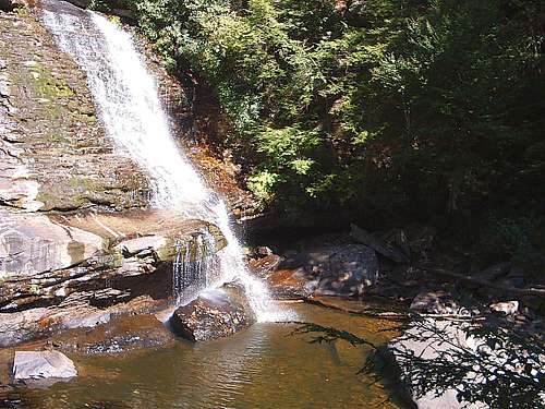
Swallow Falls State Park, Maryland
Approaching Muddy Creek Falls.
Near Muddy Creek confluence.
Maryland's highest waterfall.
Eye-catching Swallow Rock.
The only downside to the Swallow Falls campground was that, with this being a holiday weekend, there was an abundance of noisy people around. Despite many of my campsite neighbors’ best efforts, I still managed a reasonable night’s sleep through the chilly night. At sunrise, I had a little time to explore the park’s trails before beginning my return drive for home, so I swiftly put away my tent, put on another layer of clothing, and started on the Swallow Falls trails.
The most magnificent feature of the park is Muddy Creek Falls, billed as the highest waterfall in the state. While the water volume was dreadfully low on this morning, the waterfall softly cascading down the rock face was a pretty sight. Small trickles of water flowed from the pool at the base to join the Youghiogheny River a short walk downstream. I followed the trail south through the interior old-growth hemlock and white pine forest. It is utterly amazing how much of the land's original forests have been cut down at some point since colonization, but this place is one of the rare exceptions. The thick trunks tower above you here.
I hiked the full trail to the dry Tolliver Falls area, but the most enjoyable hiking here was on the river itself. The low water levels allowed a great opportunity for rock-hopping along the entire section of the river within the park. I walked on the large flattened boulders of the river bed northward, past the small named Swallow Falls and Lower Falls areas, all the way back to the Muddy Creek confluence. The boulders scattered across the flowing water created several small pockets and channels of swift current. In an absent-minded moment, I lost my balance above one of these channels and dropped my extra camera batteries. I did manage to hold on to the camera so I could take several photographs of the river, and I grabbed a souvenir rock from it near Swallow Rock, one of the neat rock formations that line the river here.
Muddy Creek Falls, and a half-mile downstream, the Youghiogheny River.
After a full morning of exploring these Swallow Falls trails, I neared the time where I had to begin my return trip home. My uneventful drive back was shorter than I anticipated, and I almost reached home before sunset. This concluded four wonderful days within West Virginia and its bordering mountains.
"Almost heaven, West Virginia ...
Blue ridge mountains, Shenandoah river.
Life is old there, older than the trees,
Younger than the mountains, growin' like a breeze ..."
Parents refers to a larger category under which an object falls. For example, theAconcagua mountain page has the 'Aconcagua Group' and the 'Seven Summits' asparents and is a parent itself to many routes, photos, and Trip Reports.


Comments
Post a Comment